
MyTopo
Classic USGS Lonaconing Maryland 7.5'x7.5' Topo Map
Couldn't load pickup availability
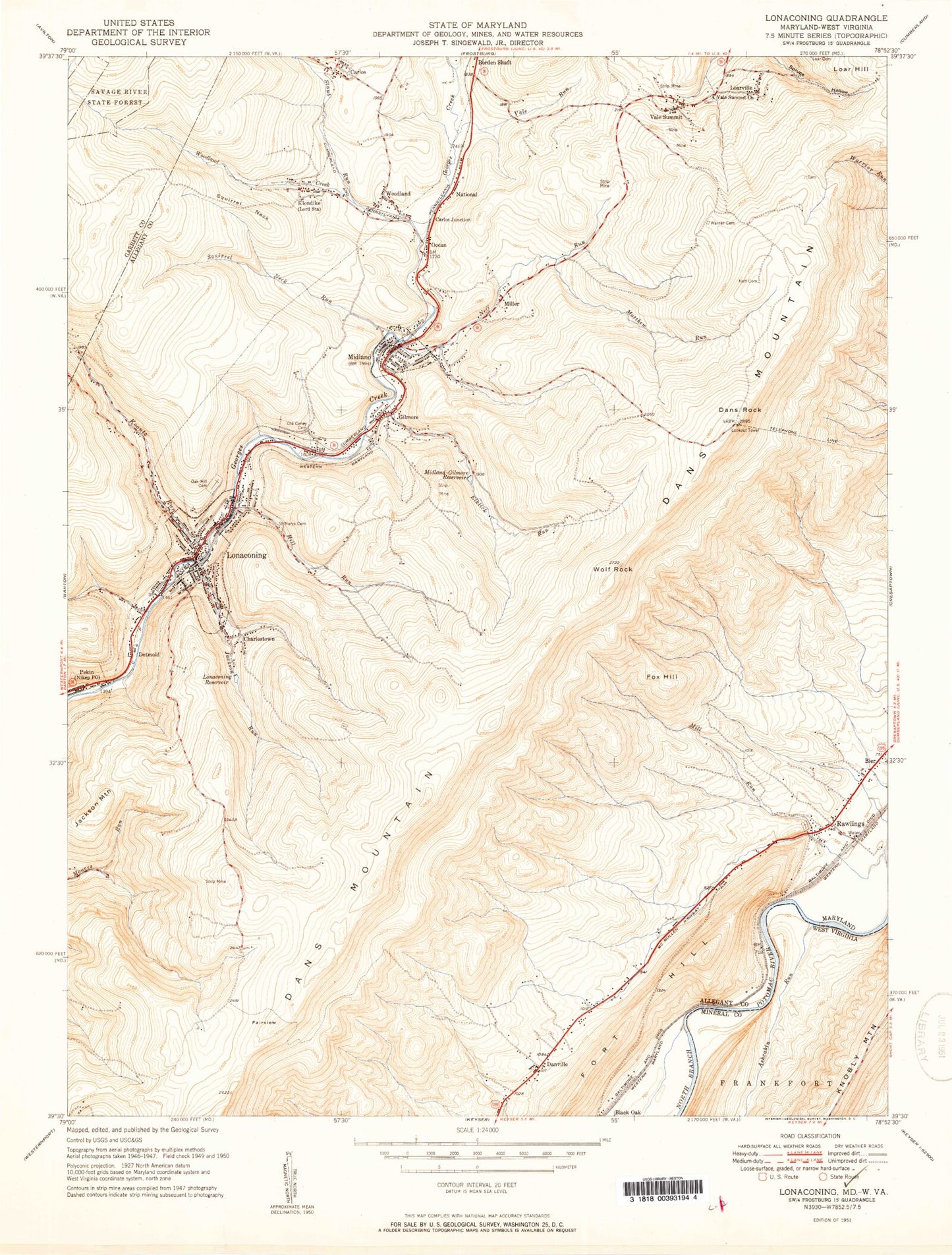
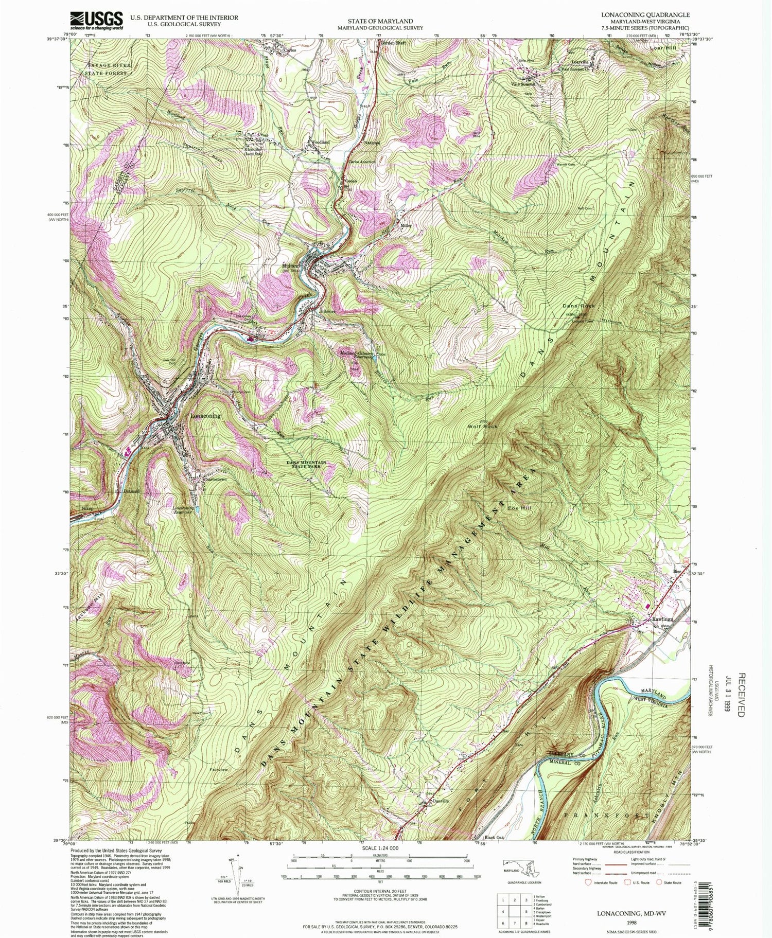
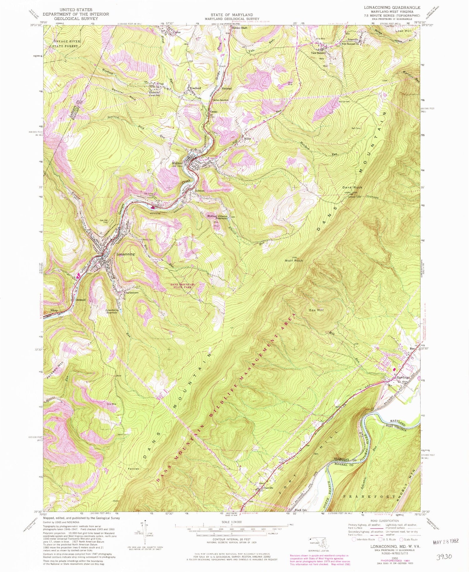
Historical USGS topographic quad map of Lonaconing in the states of Maryland, West Virginia. Typical map scale is 1:24,000, but may vary for certain years, if available. Print size: 24" x 27"
This quadrangle is in the following counties: Allegany, Garrett, Mineral.
The map contains contour lines, roads, rivers, towns, and lakes. Printed on high-quality waterproof paper with UV fade-resistant inks, and shipped rolled.
Contains the following named places: Elklick Run, Hill Run, Jackson Run, Koontz Run, Lonaconing Reservoir, Matthew Run, Midland, Midland-Gilmore Reservoir, Neff Cemetery, Neff Run, Oak Hill Cemetery, Old Coney Cemetery, Saint Marys Cemetery, Squirrel Neck, Squirrel Neck Run, Staub Run, Vale Run, Vale Summit United Methodist Church, Warner Cemetery, Winebrenner Run, Woodland Creek, Bier, Dans Rock, Carlos, Carlos Junction, Charlestown, Dans Mountain, Danville, Detmold, Fairview, Fort Hill, Fox Hill, Gilmore, Jackson Mountain, Klondike, Loarville, Lonaconing, Miller, National, Nikep, Ocean, Rawlings, Vale Summit, Wolf Rock, Woodland, WKGO-FM (Cumberland), WROG-FM (Cumberland), WLIC-FM (Frostburg), WFWM-FM (Frostburg), Cresap Cemetery, Dans Mountain State Park, George's Creek Elementary School, Koontz, Lonaconing Historic District, Lonaconing Post Office, Porters (historical), Rawlings Heights, Rawlings Post Office, Rawlings United Methodist Church, Westmar Middle School, Waxler Cemetery, Carlos United Methodist Church, Grace United Methodist Church, Midland Post Office, Midland School (historical), Saint Josephs Roman Catholic Church, Saint Josephs School (historical), Woodland United Methodist Church, Dans Mountain Wildlife Management Area, District 10 Lonaconing, District 17 Vale Summit (historical), District 18 Midland/Shaft, District 18 Ocean (historical), District 31 McCoole, District 7 Rawlings (historical), Rawlings Volunteer Fire Department, Good Will Volunteer Fire Company 1, Midland Fire Company 1, Town of Lonaconing, Town of Midland, Marsh Field Airport (historical), Rawlings Volunteer Fire Department, Carlos Census Designated Place, Danville Census Designated Place, Detmold Census Designated Place, Gilmore Census Designated Place, Klondike Census Designated Place, National Census Designated Place, Nikep Census Designated Place, Ocean Census Designated Place, Rawlings Census Designated Place, Vale Summit Census Designated Place, Woodland Census Designated Place, Georges Creek Ambulance Service, Mountainview Landfill, Lonaconing Police Department, Ashcabin Run, Elklick Run, Hill Run, Jackson Run, Koontz Run, Lonaconing Reservoir, Matthew Run, Midland, Midland-Gilmore Reservoir, Neff Cemetery, Neff Run, Oak Hill Cemetery, Old Coney Cemetery, Saint Marys Cemetery, Squirrel Neck, Squirrel Neck Run, Staub Run, Vale Run, Vale Summit United Methodist Church, Warner Cemetery, Winebrenner Run, Woodland Creek, Bier, Dans Rock, Carlos, Carlos Junction, Charlestown, Dans Mountain, Danville, Detmold, Fairview, Fort Hill, Fox Hill, Gilmore, Jackson Mountain, Klondike, Loarville, Lonaconing, Miller, National, Nikep, Ocean, Rawlings, Vale Summit, Wolf Rock, Woodland, WKGO-FM (Cumberland), WROG-FM (Cumberland), WLIC-FM (Frostburg), WFWM-FM (Frostburg), Cresap Cemetery, Dans Mountain State Park, George's Creek Elementary School, Koontz, Lonaconing Historic District, Lonaconing Post Office, Porters (historical), Rawlings Heights, Rawlings Post Office, Rawlings United Methodist Church, Westmar Middle School, Waxler Cemetery, Carlos United Methodist Church, Grace United Methodist Church, Midland Post Office, Midland School (historical), Saint Josephs Roman Catholic Church, Saint Josephs School (historical), Woodland United Methodist Church, Dans Mountain Wildlife Management Area, District 10 Lonaconing, District 17 Vale Summit (historical), District 18 Midland/Shaft, District 18 Ocean (historical), District 31 McCoole, District 7 Rawlings (historical), Rawlings Volunteer Fire Department, Good Will Volunteer Fire Company 1, Midland Fire Company 1, Town of Lonaconing, Town of Midland, Marsh Field Airport (historical), Rawlings Volunteer Fire Department, Carlos Census Designated Place, Danville Census Designated Place, Detmold Census Designated Place, Gilmore Census Designated Place, Klondike Census Designated Place, National Census Designated Place, Nikep Census Designated Place, Ocean Census Designated Place, Rawlings Census Designated Place, Vale Summit Census Designated Place, Woodland Census Designated Place, Georges Creek Ambulance Service, Mountainview Landfill, Lonaconing Police Department, Ashcabin Run