MyTopo
Classic USGS Long Branch New Jersey 7.5'x7.5' Topo Map
Couldn't load pickup availability
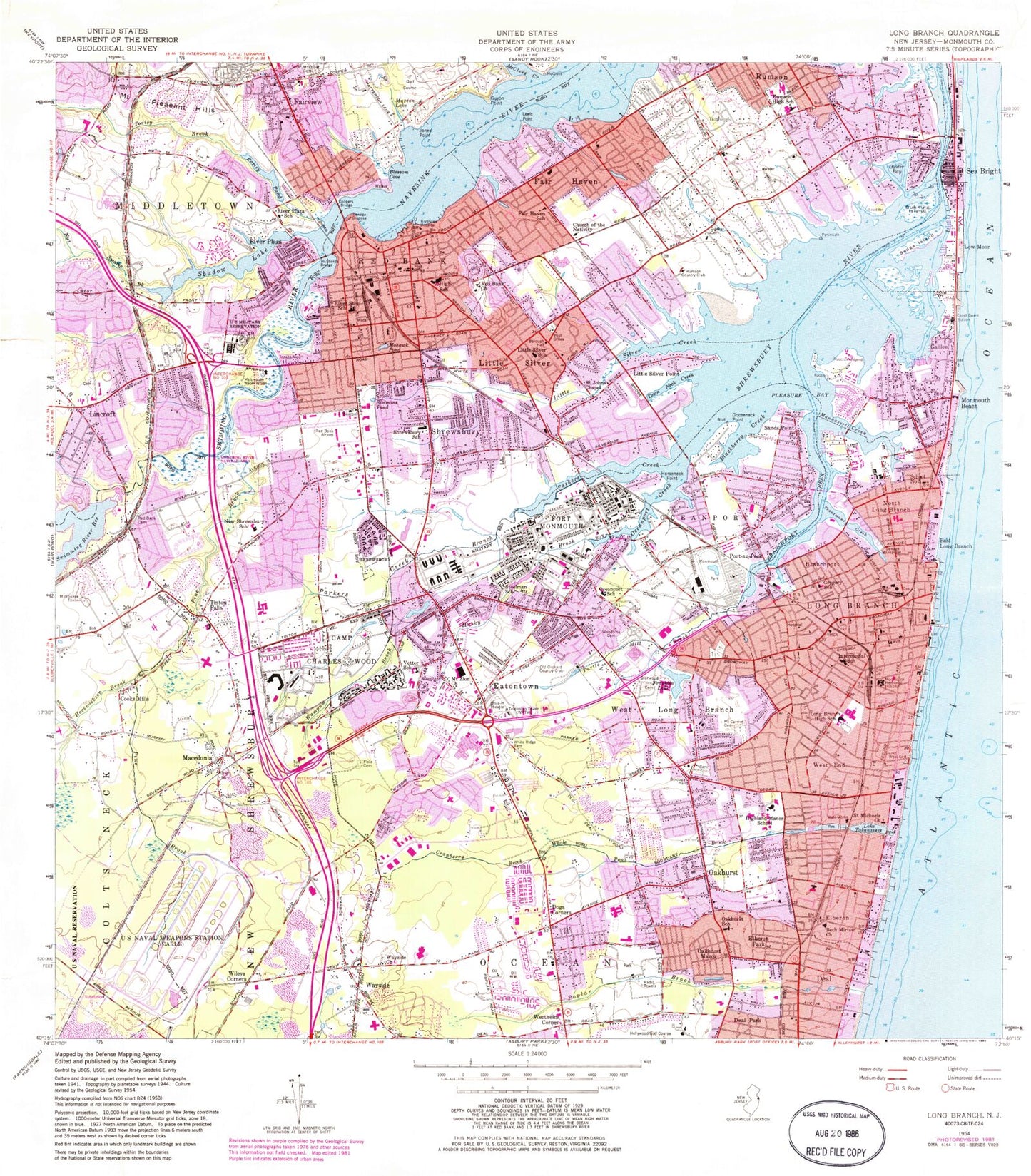
Historical USGS topographic quad map of Long Branch in the state of New Jersey. Typical map scale is 1:24,000, but may vary for certain years, if available. Print size: 24" x 27"
This quadrangle is in the following counties: Monmouth.
The map contains contour lines, roads, rivers, towns, and lakes. Printed on high-quality waterproof paper with UV fade-resistant inks, and shipped rolled.
Contains the following named places: Temple Beth Miriam, Blackberry Bay, Blossom Cove, Branchport, Branchport Creek, Camp Charles Wood, Church of the Nativity, Cooks Mills, Coopers Bridge, Cranberry Brook, Deal Park, Dogs Corners, East Long Branch, Eatontown, Elberon, Elberon Park, Fair Haven, Knollwood Elementary School, Fairview, Fair View Cemetery, Fields Cemetery, Franklin Lake, Galilee, Glenwood Cemetery, Gooseneck Point, Gregory Elementary School, Gunning Island, Monmouth University, Hockhockson Brook, Horseneck Point, Hubbards Bridge, Husky Brook, Intermedial School, Jones Point, Lewis Point, Lincroft, Little Silver, Little Silver Creek, Little Silver Point, Markham Place Elementary School, Long Branch, Long Branch High School, Low Moor, Macedonia, Manahassett Creek, Marion Lake, McClees Creek, Mohawk Pond, Monmouth Beach, Monmouth Medical Center, Monmouth Race Track, Mount Carmel Cemetery, Mount Zion African Methodist Episcopal Zion Church, Mahala F Atchinson Elementary School, North Long Branch, Nut Swamp Brook, Oakhurst, Oakhurst Manor, Oakhurst School, Oceanport, Oceanport Creek, Wolf Hill Elementary School, Oyster Bay, Parkers Creek, Parkers Creek Branch, Pine Brook, Pleasure Bay, Poplar Brook, Poricy Brook, Poricy Pond, Port-au-Peck, Quaker Cemetery, Raccoon Island, Red Bank, Red Bank Hebrew Cemetery, Red Bank Church, River Plaza Elementary School, River Street School, Riverview Medical Center, Rumson, Rumson Fair Haven Regional High School, Saint John's Episcopal Church, Saint Michaels Roman Catholic Church, Sands Point, School Number 3, Sea Bright, Sedge Island, Shrewsbury, Shrewsbury Elementary School, Simmons Pond, Steelman School, Swimming River, Lake Takanassee, Tinton Falls, Town Neck Creek, Troutmans Creek, Turtle Mill Brook, Margaret L Vetter Elementary School, Wampum Brook, Wayside, Wayside United Methodist Church, Wertheins Corner, West End, West Long Branch, Whale Pond Brook, White Ridge Cemetery, Wileys Corners, Woodbine Cemetery and Mausoleum, Township of Ocean, Township of Shrewsbury, Alexanders-Eatontown (historical), Monmouth Beach (historical), Marine Park (historical), E A I Landing Strip, Guyon Point, Highland Manor School, Red Bank Airport (historical), River Plaza, WRTV Radio Tower (Conway), Fair Haven Reach, Fourth Creek, Long Branch Reach, Red Bank Reach, Rumson Neck, Waterloo, Shrewsbury Bay, Red Bank Regional High School, Lincroft Park, West Shrewsbury, Pine Brook, Monmouth Regional High School, East Long Branch Station, Branchport Station, Poricy Dam, Swimming River Reservoir Dam, Shadow Lake, Shadow Lake Dam, Franklin Lake Dam, Eatontown Dam, Old Orchard Country Club, Rumson Country Club, WHTG-AM (Eatontown), WHTG-FM (Eatontown), WZVU-FM (Long Branch), WMCX-FM (West Long Branch), Due Process Stables Heliport, Mosquito Commission Headquarters Heliport, Greely Helipad, Charles Wood Helipad, Highlands Seaplane Base, 185 Monmouth Parkway Associates Helistop, Borough of Eatontown, Borough of Fair Haven, Borough of Little Silver, City of Long Branch, Borough of Monmouth Beach, Borough of Oceanport, Borough of Red Bank, Borough of Rumson, Borough of Sea Bright, Borough of Shrewsbury, Borough of Tinton Falls, Borough of West Long Branch, Wayside Cemetery, Eatontown Industrial Park, Fort Monmouth Golf Club, Mid - Monmouth Industrial Park, Monmouth Mall Shopping Center, Navesink Country Club, Shrewsbury Plaza Shopping Center, The Grove Shopping Center, Blackberry Bay Park, Bodman Park, Branchport Park, Elberon Park, Garfield Park, Jerry Morgan Park, Joe Palaia Park, John Parker Park, Manson Park, Normandy Park, Pleasure Bay Park, Poricy Park, Seven Presidents Park, Stevenson Park, Takanassee Lake Park, Weltz Park, Wolf Hill Recreation Area, Shippees Pond, Monmouth Water Works, Betty McElmon Elementary School, Deane Porter Elementary School, Elberon Elementary School, Fairview Elementary School, Forrestdale Middle School, Frank Antonides Elementary School, Lenna W Conrow Elementary School, Long Branch Middle School, Maple Place Elementary School, Meadowbrook Elementary School, Memorial Elementary School, Monmouth Beach Elementary School, Nut Swamp Elementary School, Ocean Township Elementary School, Ocean Township High School, Ocean Township Intermediate School, Point Road Elementary School, Red Bank Middle School, Red Bank Primary School, Shore Regional High School, Swimming River Elementary School, Thompson Middle School, Tinton Falls Middle School, Wayside Elementary School, West End Elementary School, Woodmere Elementary School, Hollywood Golf Course, Greenlawn Cemetery, Saint James Church (historical), Saint Peters Church (historical), Deans Nursery (historical), Marathon Dance Pier, Monmouth Beach Club, Norwood Country Club (historical), Shore Acres Estate, Swimming River Country Club (historical), Wolf Hills Farm (historical), Pine Brook School (historical), Rumson Country Day School (historical), Swimming River Natural Area, Camp Coles (historical), Living Hope Fellowship Church, Lutheran Church of the Reformation, First Reformed Church of Long Branch, First Baptist Church, Saint Luke's United Methodist Church