MyTopo
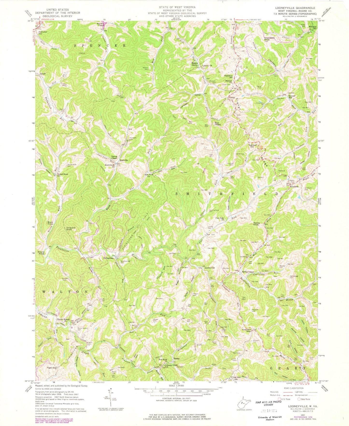
Classic USGS Looneyville West Virginia 7.5'x7.5' Topo Map
Couldn't load pickup availability
Historical USGS topographic quad map of Looneyville in the state of West Virginia. Typical map scale is 1:24,000, but may vary for certain years, if available. Print size: 24" x 27"
This quadrangle is in the following counties: Roane.
The map contains contour lines, roads, rivers, towns, and lakes. Printed on high-quality waterproof paper with UV fade-resistant inks, and shipped rolled.
Contains the following named places: Banner Church, Banner School (historical), Bays Cemetery, Bays Cemetery, Bay's Chapel United Methodist Church, Beelick Run, Big Hollow, Boggs Hollow, Brannon Cemetery, Cave Hollow, Chambers Fork, Chambers Knob, Chambers School (historical), Clarkson Fork, Claylick Run, Clover Cemetery, Clover Ridge, Coal Lick Run, Coalstone Run, Cook Cemetery, Cox Cemetery, Cranesnest Run, Criner Cemetery, Dalton Chapel, Deverick Cemetery, Dry Fork, Epling Chapel, Fairview School (historical), Ferrell Cemetery, Ferrell Cemetery, Ferrell Hollow, Ferrell Hollow, Flat Fork Church, Greathouse Hollow, Hall Cemetery, Harper Cemetery, Hascue Cemetery, Hershberger Cemetery, Hickle Hollow, Hollywood Fork, Hundley Chapel, Jack Fork, Johnson Creek School (historical), Keffer Cemetery, Kelley Cemetery, Kelley Cemetery, Kincaid Cemetery, Laurel Fork, Laurel Run, Liberty Church, Looney Cemetery, Lyehopper Hollow, Maldon Run, Meadows Cemetery, Millstone Run, Millstone School (historical), Monroe Cemetery, Monroe Hollow, Mud Fork, Mud Fork, Nida Cemetery, Oak Hill School (historical), Pad Fork, Red Knob Church, Rock Hollow, Rocky Branch, Rocky Branch Cemetery, Rocky Branch Church, Roe Hollow, Round Knob Cemetery, Round Knob Run, Round Knob School (historical), Rush Creek, Rush Creek Church, Sergent Cemetery, Shammon Branch, Showens Run, Simmons Cemetery, Sinnett Hollow, Slab Fork, Slab Fork Church, Smith Cemetery, Smith Run, Stalnaker School (historical), Stone Cemetery, Sugar Run, Summerfield Cemetery, Summerfield Cemetery, Summers Fork, Swank Cemetery, Taylor Cemetery, Tiger Gap, Vineyard Cemetery, Vineyard Cemetery, Vineyard Cemetery, Vineyard Gap, Vineyard Run, Watson Cemetery, Webb Cemetery, Harley, Looneyville, Roxalana, Rushville, Stringtown, Roane County, Flat Fork, Buck Knob, Clover, Keeley Knob, Round Knob, Vineyard Knob, Walnut Grove, Clover Ridge Oil Field, Stringtown Oil Field, Oldham Lake Dam, Lawsons Farm Lake Dam, Buffalolick (historical), Clover Post Office (historical), Jackson Fork, Looneyville Post Office, Pad (historical), Shad (historical), Shamblings Mills (historical), Eastern District (historical), Clover - Roane Volunteer Fire Department, Eplin Chapel Cemetery, Coe - Holland Cemetery, Looneyville Arch Bridge