
MyTopo
Classic USGS Lost Mountain Georgia 7.5'x7.5' Topo Map
Couldn't load pickup availability
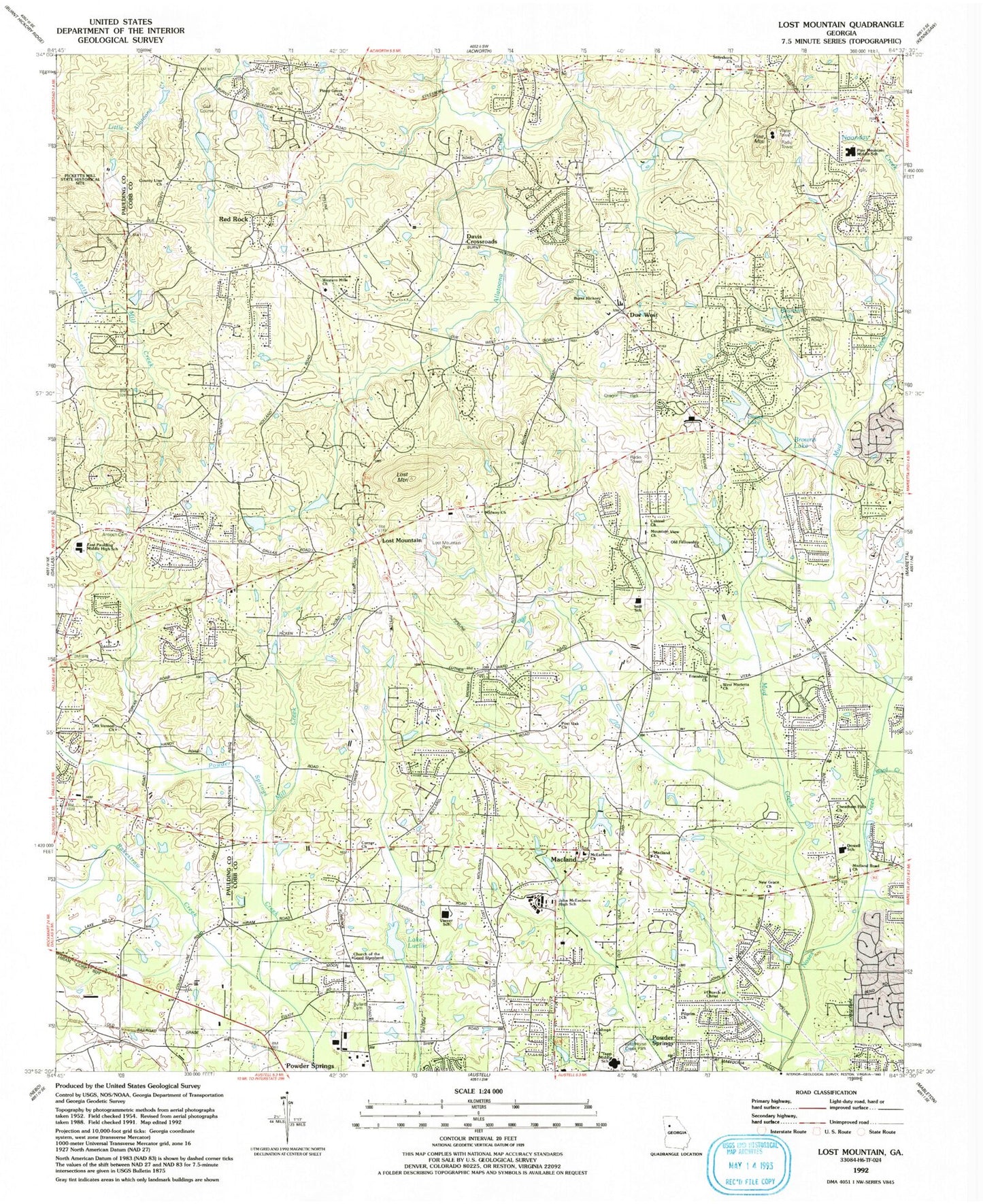
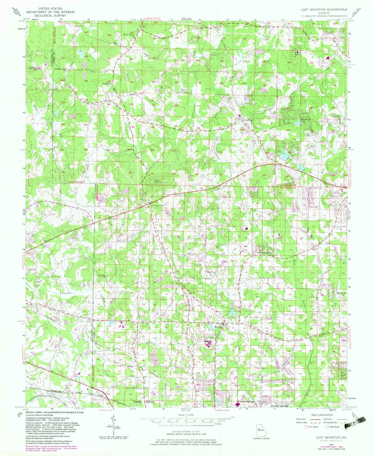
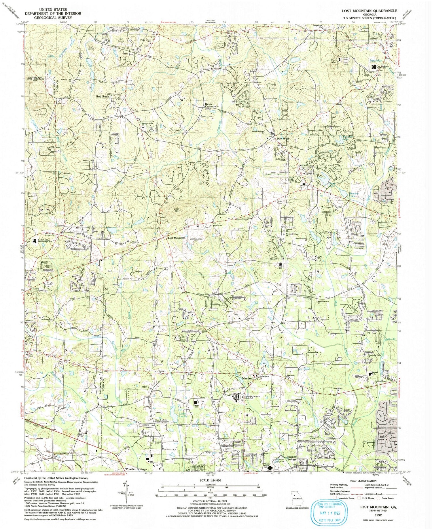
Historical USGS topographic quad map of Lost Mountain in the state of Georgia. Typical map scale is 1:24,000, but may vary for certain years, if available. Print size: 24" x 27"
This quadrangle is in the following counties: Cobb, Paulding.
The map contains contour lines, roads, rivers, towns, and lakes. Printed on high-quality waterproof paper with UV fade-resistant inks, and shipped rolled.
Contains the following named places: Bearden Lake, Cheatham Hill Community Club, Corner Church, County Line Church, Due West, John McEachern School, Midway Church, Mill Creek, Mud Creek, Piney Grove Baptist Church, Post Oak Baptist Church, Rakestraw Creek, Mount Vernon Cemetery, Ward Creek, Lost Mountain, Lost Mountain, Macland, Davis Crossroads, Red Rock, Boots Wards Recreational Center, Dowell Elementary School, West Marietta Church, Kemo Library, Tapp Middle School, Old Fellowship Church, Red Rock Community Club, John McEachern High School, Mountain View Church, Lake Lucile, Varner Elementary School, Casteel Church, Browns Lake, Corns Lake, Still Elementary School, Lost Mountain Church of God, East Paulding High School, Lost Mountain Baptist Church, Wild Horse Creek Park, Pine Mountain Middle School, Mount Vernon Church, Lost Mountain Park, Due West Elementary School, Stilesboro Church, Oregon Park, Pilgrim Church, Kirkwood Church, Church of Christ, Battle of Gilgal Church, Macland Road Church, Browns Chapel, Cheatham Hills Church, Due West Church, New Grace Church, Burnt Hickory Church, Macland Church, Canaan Church, McEachern Church, Church of the Good Shepherd, Western Hills Baptist Church, Bullard Cemetery, Mount Vernon Cemetery, Antioch Cemetery, Mount Vernon Church, Picketts Mill State Historical Site, Fort Yargo Lake Dam, Fort Yargo Lake, Ganoname1156 Dam, Lake Somerset Dam, Mud Creek Lake Dam, Mud Creek Lake Dam, Wofford Lake Dam, Wofford Lake, Brooks Farm, California, Cobb Crossing, Creekwood Estates, Due West Estates, Fox Ridge, Gold Creek, Hardy Hills, Hearthwood, Lost Mountain Woods, Powder Creek Crossing, Powder Mill, Southfork, Sunny Industrial Park, Timberchase, Watson Glen, Friendship Church, Pine Mountain, Calumet West, Church of Christ Cemetery, Country Lake, County Line Cemetery, Cross Creek Estates, Davis Cemetery, Echols Cemetery, Fairfield Cemetery, Kemp Cemetery, Macland Cemetery, McEachern Woods, Midway Cemetery, Moon Cemetery, New Friendship Cemetery, Piney Grove Cemetery, Post Oak Cemetery, Red Rock Hills, Rocky Springs Cemetery, Shipp - Old Lost Mountain Cemetery, Story (historical), West Hampton, Wynford Chase, Acworth-Kennesaw Division, Brookstone Village Shopping Center, Citizens Square Shopping Center, Cobb County Fire and Emergency Services Station 13, Cobb County Fire and Emergency Services Station 18, Cobb County Fire and Emergency Services Station 24, Dominion Christian High School, Lost Mountain Crossing Shopping Center, Lost Mountain Middle School, MacLand Corner Shopping Center, Metromont Shopping Center, Stilesboro Oaks Shopping Center, Hayes Elementary School, Montessori School at Brookstone, Harrison High School, Vaughan Elementary School, East Paulding Middle School, Hillgrove High School, Lovinggood Middle School, Ford Elementary School, Dominion Christian High School, Midway Covenant Christian School, McEachern High School, Kemp Elementary School, Trinity Chapel, Cobb County Police Department Precinct 5, Brookstone Post Office