MyTopo
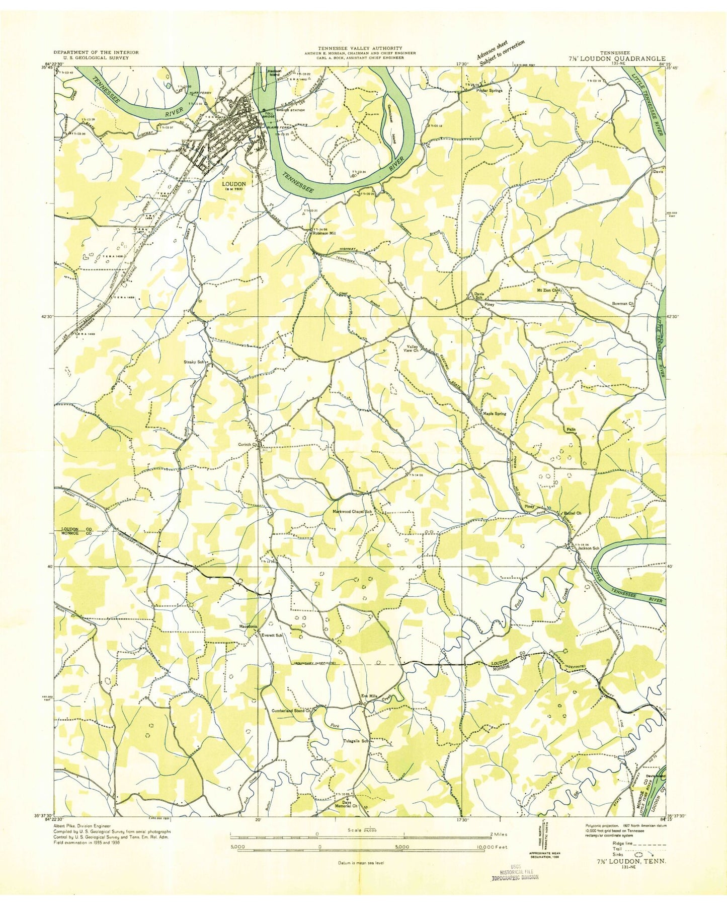
Classic USGS Loudon Tennessee 7.5'x7.5' Topo Map
Couldn't load pickup availability
Historical USGS topographic quad map of Loudon in the state of Tennessee. Map scale may vary for some years, but is generally around 1:24,000. Print size is approximately 24" x 27"
This quadrangle is in the following counties: Loudon, Monroe.
The map contains contour lines, roads, rivers, towns, and lakes. Printed on high-quality waterproof paper with UV fade-resistant inks, and shipped rolled.
Contains the following named places: Andersons Ferry, Bacon Hospital, Bat Creek, Bethel Church, Big Piney, Blair Bend, Blair Bend Industrial Park, Blair Bluff, Blairs Ferry, Blankenship Shoals, Bowman Cemetery, Bowman Church, Briar Ridge, Burton Branch, Burton Mill, Carmichael Inn Museum, Carmichael Island, Cemetery Union Church, Clear Creek Recreation Area, Clear Prong, Clemmer Cemetery, Coffman Cemetery, Commissioner District 1, Commissioner District 7, Corinth Church, Cumberland Stand Church, Davis, Davis Cemetery, Davis School, Eve Mills, Everett School, First Baptist Church, Fork Creek, Fort Loudoun Middle School, Hays Memorial Church, Hickman Cemetery, High Top, Huff Ferry, Jackson Bend, Jackson School, LIttle Valley, Loudon, Loudon Bridge, Loudon Church of the Nazarene, Loudon City Hall, Loudon County, Loudon County Courthouse, Loudon County Fire Rescue Station 4 - Piney, Loudon Cumberland Presbyterian Church, Loudon Division, Loudon Elementary School, Loudon Fire Department Station 1, Loudon High School, Loudon Junior High School, Loudon Marine Park, Loudon Police Department Headquarters, Loudon Post Office, Loudon United Methodist Church, Lower Coytee Shoals, Macedonia, Maple Spring, Markwood Chapel School, McKee Cemetery, Mount Olive Baptist Church, Mount Zion Baptist Church, New Macedonia Church, New Union Fork Church, Poplar Springs, Poplar Springs Baptist Church, Poplar Springs Ridge, Poplar Springs School, Rarity Bay, Rarity Bay Census Designated Place, Robertson Cemetery, Robinson Mill, Roy White Dam, Roy White Lake, Russell Cemetery, Russell Store, Simpson Cemetery, Steaky School, Steekee Creek, Steekee Elementary School, Sweetwater Creek, Sycamore Branch, Sycamore Hollow, Tellico Village Census Designated Place, Tellico Village Volunteer Fire Department, Terry Knob, Toliver Island, Tulagalla School, Upper Coutee Shoals, Valley View Church, Watkins Cemetery, Watson Cemetery, Watts Cemetery, Williams Branch, Williams Hollow, Winding Shoals, WLNT-AM (Loudon), ZIP Code: 37774