MyTopo
Classic USGS Louellen Kentucky 7.5'x7.5' Topo Map
Couldn't load pickup availability
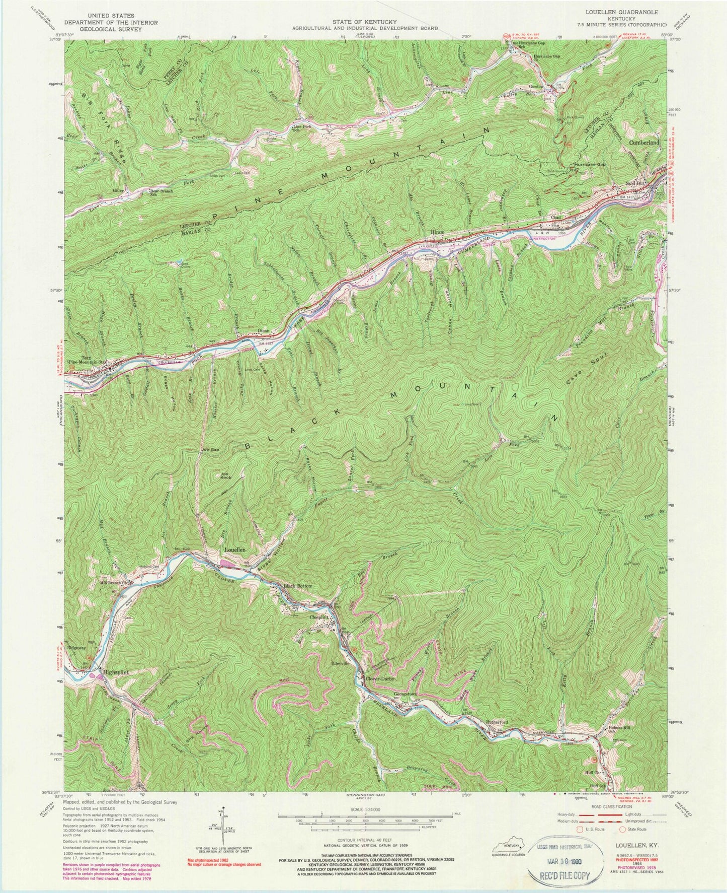
Historical USGS topographic quad map of Louellen in the state of Kentucky. Map scale may vary for some years, but is generally around 1:24,000. Print size is approximately 24" x 27"
This quadrangle is in the following counties: Harlan, Letcher, Perry.
The map contains contour lines, roads, rivers, towns, and lakes. Printed on high-quality waterproof paper with UV fade-resistant inks, and shipped rolled.
Contains the following named places: Abe Branch, Abner Fork, Archies Branch, Arthur Post Office, Ashhopper Branch, Banks Branch, Bear Branch, Bear Branch School, Big Fork Ridge, Big Jonathan Branch, Black Bottom, Boggs Hollow, Breedens Creek, Bridge Branch, Brown Branch, Browning Creek, Canoe Hollow, Cave Spur Ridge, Chad, Chad Branch, Chad Post Office, Chad Railroad Station, Cherrytree Branch, Childs Branch, Clearbrook Railroad Station Number One, Closplint, Closplint Post Office, Closplint Railroad Station Number One, Closplint Railroad Station Number Two, Clover-Darby, Colton Railroad Station, Cornett Branch, Cornett Cemetery, Cornett Railroad Station, Creech Post Office, Days Creek, Devall Post Office, Dione, Dione Post Office, Dione Railroad Station, Dora Branch, Dry Branch, Eastep Branch, Eloise Branch, Fanny Wynn Branch, Flat Branch, Fugitt Creek, Garner Gap, Georgetown, Gilley, Gilley Branch, Golva Railroad Station, Gordon, Gordon Post Office, Gordon Volunteer Fire Department, Grassy Gap, Hall Cemetery, Harlan County Rural Fire Department Station 2, Hi Lewis Branch, Highsplint, Highsplint Post Office, Highsplint Railroad Station, Hiram, Hiram Post Office, Hiram Railroad Station, Holmes Mill Elementary School, Hooser Branch, Huff Church, Huff School, Hugh Branch, Hurricane Gap, Hurricane Gap Church, Hurricane Gap Mountain, Hurricane Gap School, Indian Grave Gap, Island Branch, Jacks Branch, Jacks Fork, Jakes Creek, Jerry Fork, Joe Branch, Joe Gap, Joe Knob, Judes Branch, Kate Branch, Kelly Branch, Kelly Cemetery, Kinlaw Railroad Station, Klondike Post Office, Koyle Branch, Laurel Fork, Laurelpatch Branch, Left Fork Fugitt Creek, Left Fork Kelly Branch, Left Fork Koyle Branch, Leonard Post Office, Lewis Branch, Lewis Cemetery, Lick Branch, Lick Fork, Line Fork School, Little Laurelpatch Branch, Long Branch, Long Ridge, Louellen, Louellen Post Office, Low Gap Fork, Mary Wynn Branch, Meadow Hollow, Mill Branch, Mill Branch Church, Milton, Nolan Branch, Old Mill Hollow, Oldhouse Branch, Oxstall Branch, Penley Branch, Perkins Branch, Pounding Mill Branch, Raybon Railroad Station, Riddle Cemetery, Ridgeway Post Office, Right Fork Breedens Creek, Rileyville, Road Fork, Robbins Cemetery, Rocky Hollow, Rutherford, Salad Hollow, Sand Hill, Schoolhouse Branch, Scotts Branch, Seagraves Creek, Slip Hollow, Slope Hollow, Smith Branch, Smith Cemetery, Sourwood Gap, Star Branch, Sulaney Branch, Tantrough Branch, Totz, Totz Census Designated Place, Totz Post Office, Trace Branch, Upper Clover Fork Division, Upper Cloverfork Fire Department, Valley Branch, Whitnel Railroad Station, Windy Fork, ZIP Codes: 40828, 41819