MyTopo
Classic USGS Lower Marlboro Maryland 7.5'x7.5' Topo Map
Couldn't load pickup availability
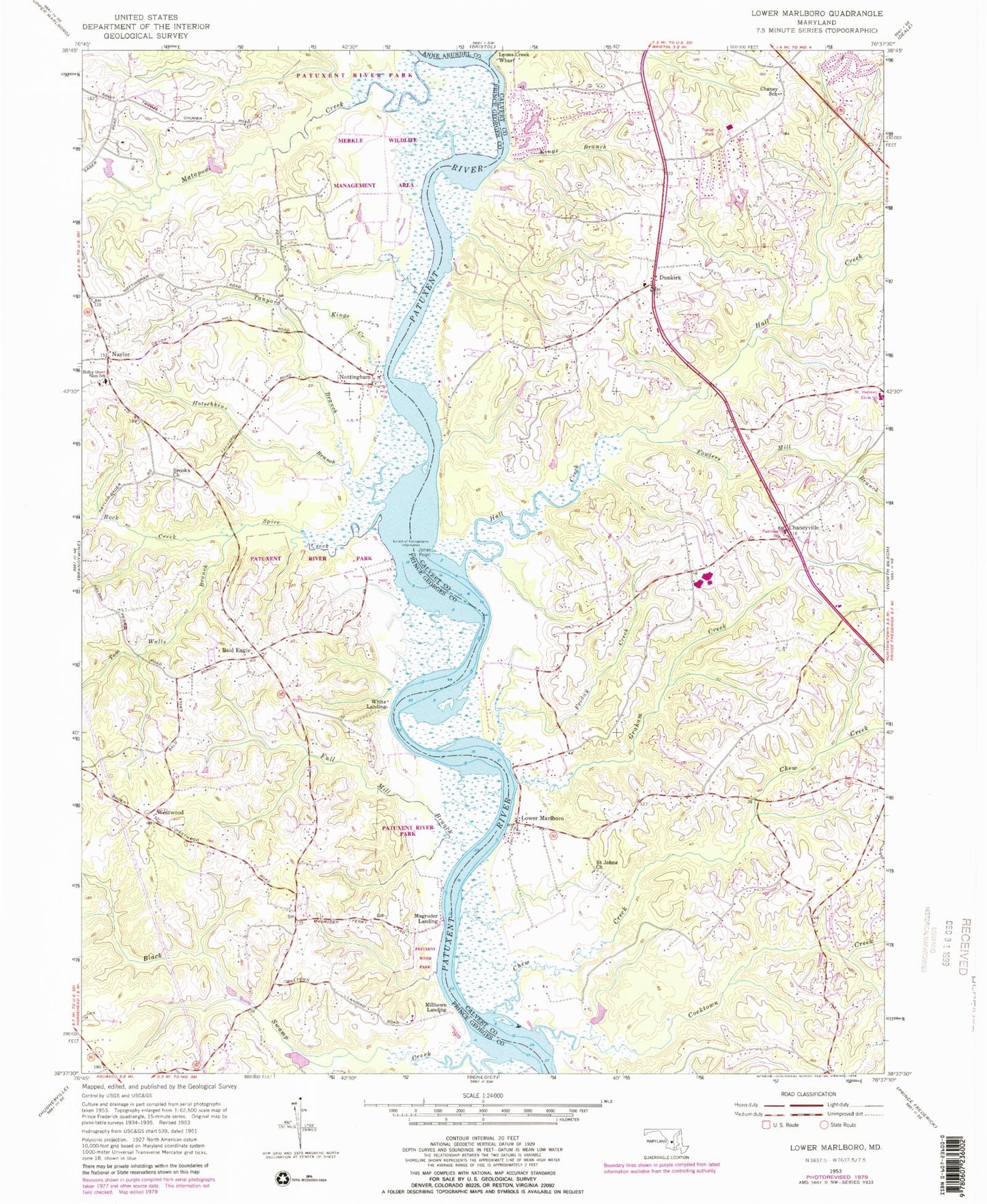
Historical USGS topographic quad map of Lower Marlboro in the state of Maryland. Typical map scale is 1:24,000, but may vary for certain years, if available. Print size: 24" x 27"
This quadrangle is in the following counties: Anne Arundel, Calvert, Prince George's.
The map contains contour lines, roads, rivers, towns, and lakes. Printed on high-quality waterproof paper with UV fade-resistant inks, and shipped rolled.
Contains the following named places: Chaney School, Chaneyville, Chew Creek, Cocktown Creek, Dunkirk, Fowlers Mill Branch, Friday Creek, Graham Creek, Hall Creek, Jones Point, Kings Branch, Lower Marlboro, Lyons Creek, Lyons Creek Wharf, Saint Johns Church, Covenant Creek, Shores of Clvert Dam Number One, Hagerstown City Park Lake, Lower Marlboro Airport (historical), Bald Eagle, Black Swamp Creek, Brooks Church, Full Mill Branch, Hotschkins Branch, Kings Creek, Magruder Landing, Mataponi Creek, Milltown Landing, Naylor, Old House Creek, Rock Creek, Spice Creek, Tanyard Branch, Tom Walls Branch, Westwood, White Landing, Short Point, Apple Greene, Ashwood Manor, Calvert Chase, Cavalier Country, Cedar Run, Cedarwood, Country Road Estates, Country Village Plaza Shopping Center, Crestwood, Dunkirk District Park, Dunkirk Fields, Dunkirk Market Place Shopping Center, Dunkirk Post Office, Dunkirk South, Dunkirk Woods, Ferry Landing, Ferry Landing Woods, Fox Hunt Estates, Howes Meadows, Lakewood Estates, Laurian, Lower Marlboro Towne, Lower Marlboro United Methodist Church, Magruder Ferry (historical), Odyssey, Owensville, Patuxent Highland (historical), Patuxent Palisades, Penwick Village, Regal Estastes, Regency Manor Mobile Home Park, Saint Johns School (historical), Shores of Calvert, Smiths Purchase Cemetery, Smithville, Smithville United Methodist Church, Sneaking Point, Southern Memorial Gardens, Welchpoole Estates, Wilson (historical), Woodlawn Farms, Academy Hill, Arbor Greene, Breezy Knoll Estates, Briarwood, Bright Acres Mobile Home Park, Calvert Manor, Castlemore, Century Estates, Chaneyville Farm Estates, Circles Trailer Park, Coopers United Methodist Church, Crow Haven Estates, Dunkirk Hall, Fairview School, Ferguson, Field Acres, Foxchase, Hall Creek School (historical), Halls Hills, Hampton Heights, Huntingtown Farms, Kings Landing, Lord Calvert Estates, MacDonald Farms, Meadow Run Park, Mill Branch Estates, Mill Seat, Mount Harmony Elementary School, Mount Harmony Estates, Mount Harmony Hills, Musgrove Estates, Northern High School, Northern Middle School, Saint Johns School (historical), Smoky, Somerset, South Hampton, Stone Farm, Sunderland Woods, Sunshine Acres, The Meadows, Wards Meadow, Bald Eagle School (historical), Bowling Landing, Brookfield United Methodist Church, Brooks View, Holley Grove Elementary School, Merkle Wildlife Management Area, Dunkirk Town Center, District 4 Nottingham, Frederick Douglass High School, Calvert County Station 5 Dunkirk Volunteer Fire Department, Cardinal Hickey Academy, Shiloh Christian Academy, Dunkirk Census Designated Place, Apple Greene Business Park 99, Calvert County Public Library - Fairview Branch, Jesus the Good Shepherd Church, The Church of Jesus Christ of Latter Day Saints, Baden Census Designated Place, Fridays Creek Winery, Romano Vineyard and Winery, Garner Field, Shiloh Methodist Episcopal Church South Cemetery