MyTopo
Classic USGS Lumberville Pennsylvania 7.5'x7.5' Topo Map
Couldn't load pickup availability
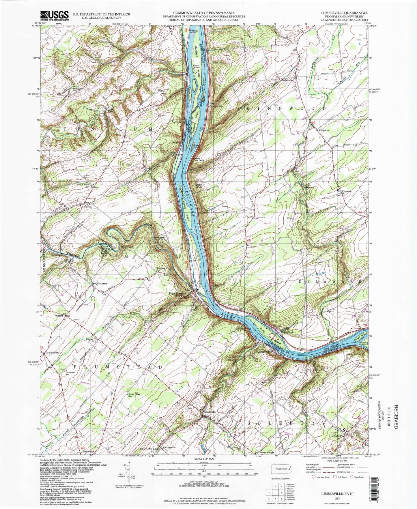
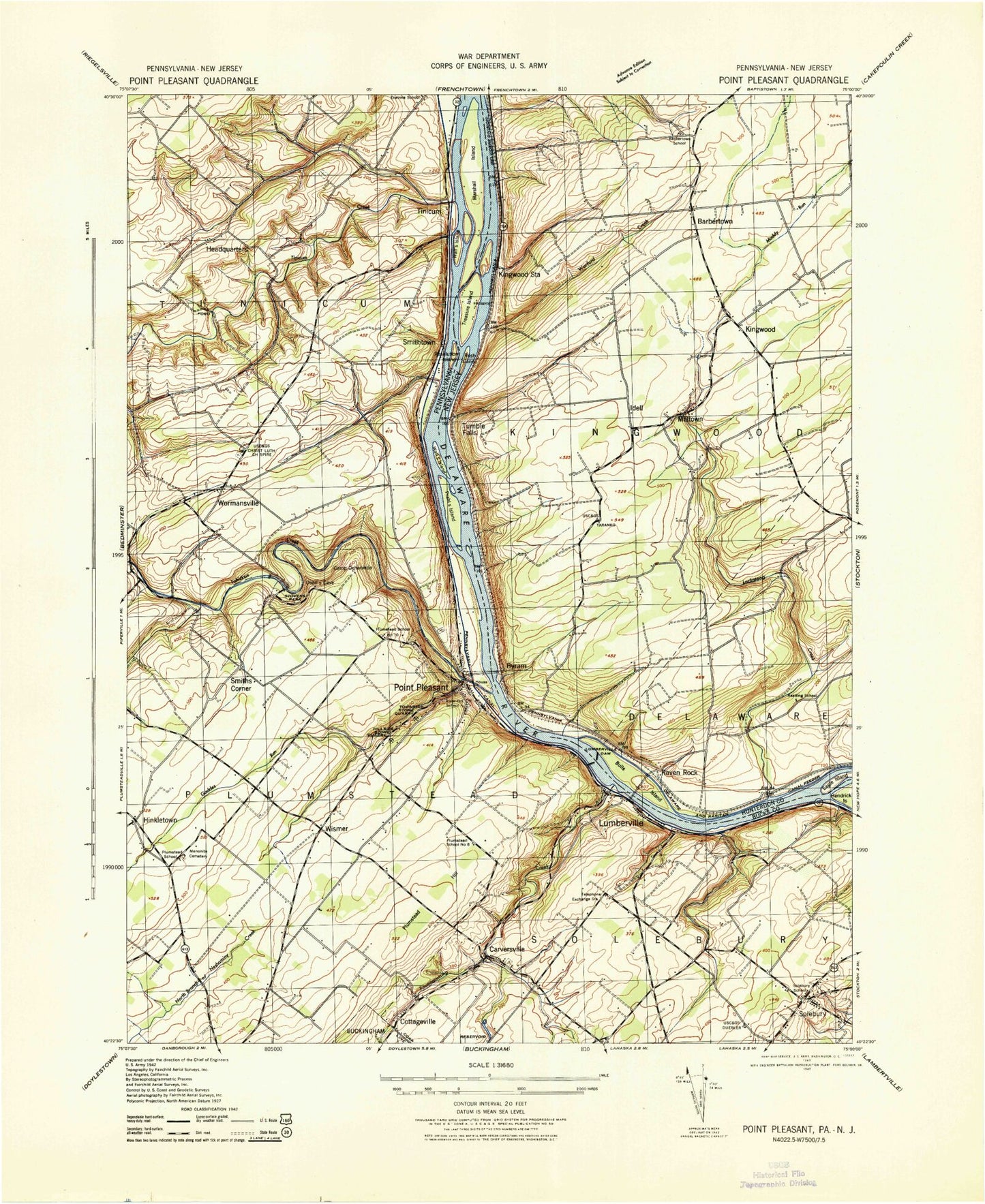
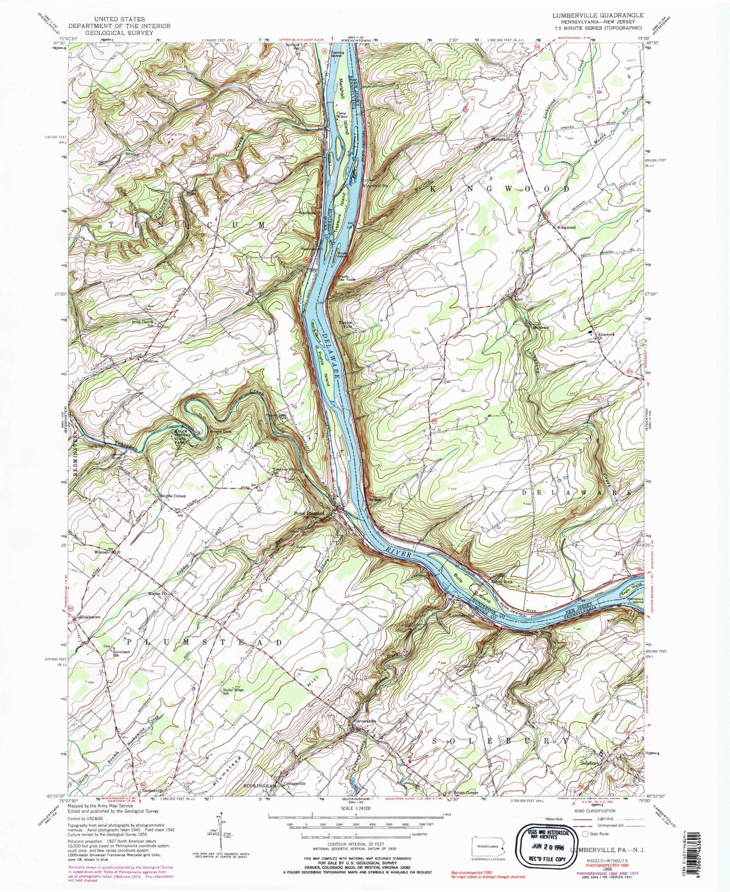
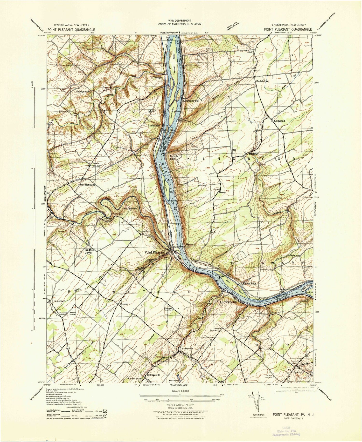
Historical USGS topographic quad map of Lumberville in the states of Pennsylvania, New Jersey. Typical map scale is 1:24,000, but may vary for certain years, if available. Print size: 24" x 27"
This quadrangle is in the following counties: Bucks, Hunterdon.
The map contains contour lines, roads, rivers, towns, and lakes. Printed on high-quality waterproof paper with UV fade-resistant inks, and shipped rolled.
Contains the following named places: Brick Church School, Cabin Run, Geddes Run, Groveland School, Hickory Creek, Hillpot Cemetery, Lily Valley, Lumberville, Paunnacussing Creek, Pleasant Valley Park, Prahls Island, Ralph Stover State Park, Resolution Island, Rocky Ridge School, Smiths Corner, Solebury, Tinicum, Tohicken Hill School, Tohickon Creek, Walls Island, Aerequus Airport, Plumstead Airfield (historical), Hoge Farm Airport, Haney Airport (historical), Vansant Airport, Ockanickon Scout Reserve, Smithtown Creek, Carversville, Cottageville, Hinkletown, Peters Corner, Point Pleasant, Smithtown, Sundale, Wismer, Wismer Post Office, Frankenfield Covered Bridge, Prahls Island County Park, Tinicum Lutheran Church, Four Brooks Church, Tinicum Elementary School, High Rocks State Park, Cabin Run Covered Bridge, Stover Myers Mill County Park, Stover Myers Mill, New Hope Solebury Elementary School, Carvers Ridge, Point Pleasant Baptist Church, Ralph Stover Dam, Myers Dam, Tohickon Valley Park, Solebury Post Office (historical), Carversville Post Office (historical), Michener Post Office (historical), Point Pleasent Post Office (historical), Township of Plumstead, Township of Tinicum, Monesmith Airport, New Hope Eagle Fire Company Station 64, Point Pleasant Fire Company Station 41, Delaware Valley Volunteer Fire Company Station 48, Ransome Airport (historical), Carversville Cemetery, Groveland Mennonite Cemetery, Lower Tinicum Union Cemetery - North, Marshall - Cooper - Ridge Cemetery, Point Pleasant Baptist Church Cemetery, Carversville Post Office, Point Pleasant Post Office, Solebury Post Office, Tinicum Township Police Department, Solebury Township Police Department, Lower Delaware Wild and Scenic River, Barbertown, Bulls Island, Byram, Devils Tea Table, Idell, Kingwood, Kingwood Church, Kingwood Station, Lockatong Creek, Lumberville Dam, Milltown, Muddy Run, Raven Rock, Rush Island, Shyhawks Island, Treasure Island, Tumble Falls, Warford Creek, Township of Kingwood, Windward Farms Airport, Bulls Island State Park, Eagles Lair Airport, Fly-N-D Landing Strip, Camp Wilson, Fishing Island, Marshall Island, Pinkertons Island, Walls Island, Tinicum Creek, Brick Church School, Cabin Run, Geddes Run, Groveland School, Hickory Creek, Hillpot Cemetery, Lily Valley, Lumberville, Paunnacussing Creek, Pleasant Valley Park, Prahls Island, Ralph Stover State Park, Resolution Island, Rocky Ridge School, Smiths Corner, Solebury, Tinicum, Tohicken Hill School, Tohickon Creek, Walls Island, Aerequus Airport, Plumstead Airfield (historical), Hoge Farm Airport, Haney Airport (historical), Vansant Airport, Ockanickon Scout Reserve, Smithtown Creek, Carversville, Cottageville, Hinkletown, Peters Corner, Point Pleasant, Smithtown, Sundale, Wismer, Wismer Post Office, Frankenfield Covered Bridge, Prahls Island County Park, Tinicum Lutheran Church, Four Brooks Church, Tinicum Elementary School, High Rocks State Park, Cabin Run Covered Bridge, Stover Myers Mill County Park, Stover Myers Mill, New Hope Solebury Elementary School, Carvers Ridge, Point Pleasant Baptist Church, Ralph Stover Dam, Myers Dam, Tohickon Valley Park, Solebury Post Office (historical), Carversville Post Office (historical), Michener Post Office (historical), Point Pleasent Post Office (historical), Township of Plumstead, Township of Tinicum, Monesmith Airport, New Hope Eagle Fire Company Station 64, Point Pleasant Fire Company Station 41, Delaware Valley Volunteer Fire Company Station 48, Ransome Airport (historical), Carversville Cemetery, Groveland Mennonite Cemetery, Lower Tinicum Union Cemetery - North, Marshall - Cooper - Ridge Cemetery, Point Pleasant Baptist Church Cemetery, Carversville Post Office, Point Pleasant Post Office, Solebury Post Office, Tinicum Township Police Department, Solebury Township Police Department, Lower Delaware Wild and Scenic River, Barbertown, Bulls Island, Byram, Devils Tea Table, Idell, Kingwood, Kingwood Church, Kingwood Station, Lockatong Creek, Lumberville Dam, Milltown, Muddy Run, Raven Rock, Rush Island, Shyhawks Island, Treasure Island, Tumble Falls, Warford Creek, Township of Kingwood, Windward Farms Airport, Bulls Island State Park, Eagles Lair Airport, Fly-N-D Landing Strip, Camp Wilson, Fishing Island, Marshall Island, Pinkertons Island, Walls Island, Tinicum Creek