MyTopo
Classic USGS Lynbrook New York 7.5'x7.5' Topo Map
Couldn't load pickup availability
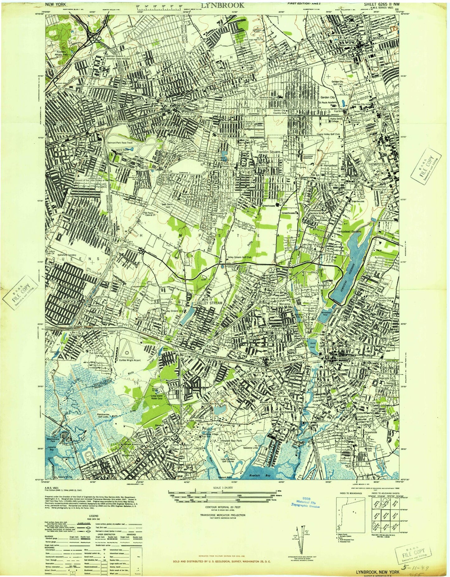
Historical USGS topographic quad map of Lynbrook in the state of New York. Map scale may vary for some years, but is generally around 1:24,000. Print size is approximately 24" x 27"
This quadrangle is in the following counties: Nassau, Queens.
The map contains contour lines, roads, rivers, towns, and lakes. Printed on high-quality waterproof paper with UV fade-resistant inks, and shipped rolled.
Contains the following named places: Alden Manor, Alley Park, Alley Park Athletic Field, Averill Boulevard Park, Bay Park, Bay Park Census Designated Place, Bay Park Golf Course, Bay Park Sewage Treatment Plant, Bellerose, Bellerose Playground, Bellerose Station, Bellerose Terrace, Bellerose Terrace Census Designated Place, Belmont Park, Belmont Park Heliport, Beth David Cemetery, Bligh Field, Breininger Park, Brook Road Park, Brookville Park, Cambria Heights, Campbell Park, Cauerbach Canal, Cedarhurst Sewage Treatment Works, Centre Avenue Station, Cherry Valley Country Club, Conselyeas Pond, Country Life Press Station, Curtiss Wright Airport, Dee's Nursery, Delphin H Greene Playground, Doxey Brook Park, Dutch Broadway Park, East Rockaway, East Rockaway Station, Echo Park, Elmont, Elmont Cemetery, Elmont Census Designated Place, Elmont Road Park, Father Reilly Square, Firemens Memorial Field, Floral Park, Floral Park Playground, Floral Park Station, Franklin Square, Franklin Square Census Designated Place, Frederick Cabbell Park, Garden City, Garden City Country Club, Garden City Golf Club, Garden City Park, Garden City Park Census Designated Place, Garden City South, Garden City South Census Designated Place, Garden City Station, Georges Creek, Gibson Station, Glen Oaks, Grand Canal, Grant Park, Grant Pond, Green Acres, Green Acres Mall Shopping Center, Greis Park, Grossmann's Farm, Halls Pond Park, Hemlock Playground, Hempstead Country Club, Hempstead Gardens, Hempstead Gardens Station, Hempstead Golf Club, Hempstead Lake, Hempstead Lake State Park, Hempstead Station, Herricks Road Park, Hewlett, Hewlett Bay, Hewlett Bay Park, Hewlett Census Designated Place, Hewlett Harbor, Hewlett Point, Hewlett Point Park, Hewlett Shopping Center, Hewlett Station, Hickey Field, Hillside Park, Hook Creek, Hook Creek Ballfield, Hook Creek Wildlife Sanctuary, Lake Kathleen Golf Course, Lakeview, Lakeview Census Designated Place, Lakeview Station, Laurelton Playground, Lister Park, Litchult Square, Lynbrook, Lynbrook Station, Macy Channel, Maimonides - Elmont Cemetery, Malverne, Malverne Park Oaks, Malverne Park Oaks Census Designated Place, Malverne Station, Meadowmere Park, Meadowview Golf Links, Mentone Playground, Merillon Avenue Station, Middle Bay Country Club, Mill River, Mineola, Mineola Fair Grounds, Mineola Station, Montefiore Cemetery, Motts Creek, Nassau Boulevard Station, New Hyde Park, New Hyde Park Station, North Lynbrook Census Designated Place, North New Hyde Park, North New Hyde Park Census Designated Place, North Valley Stream, North Valley Stream Census Designated Place, North Woodmere, North Woodmere Golf Course, North Woodmere Park, Norton Point, Oceanside, Oceanside Census Designated Place, Oceanside Station, Pat Williams Playground, Patrol Officer William T Gunn Junior Park, Pauper Burial Ground, Peninsula Shopping Center, Pines Pond, Playground 80, Powell Creek, Public School 147 Playground, Queens Farm Park, Queens Village, Queens Village Station, Queens Village Veterans Plaza, Rath Park, Reed Channel, Rockville Cemetery, Rockville Centre, Rockville Centre Station, Rockville Country Club, Rosedale, Rosedale Station, Saint Boniface Cemetery, Saint Johns Cemetery, Saint Pauls German Presbyterian Church Cemetery, Schodack Brook, Schodack Pond, Seawane Country Club, Seawene Links, Smith Pond, South Floral Park, South Pond, South Valley Stream, South Valley Stream Census Designated Place, Springfield Cemetery, Springfield Gardens, Stewart Manor, Stewart Manor Station, Stiles Athletic Field, Sunrise Drive-In, Sunrise Playground, Surrey Estates, Tanglewood Preserve, Tenney Park, Thixton Creek, Thurston Basin, Trinity Cemetery, Tullamore Playground, Uncle Daniels Point, Valley Stream, Valley Stream Golf Club, Valley Stream Pond, Valley Stream State Park, Valley Stream Station, Veterans Memorial Park, Veterans Square, Village of Bellerose, Village of Cedarhurst, Village of East Rockaway, Village of Floral Park, Village of Garden City, Village of Hewlett Bay Park, Village of Hewlett Harbor, Village of Lynbrook, Village of Malverne, Village of Mineola, Village of New Hyde Park, Village of Rockville Centre, Village of South Floral Park, Village of Stewart Manor, Village of Valley Stream, Watts Pond, Wayanda Park, West Hempstead, West Hempstead Census Designated Place, West Hempstead Station, Willow Pond, Wilson Park, Winthrop University Hospital Heliport, Woodmere, Woodmere Census Designated Place, Woodmere Station, ZIP Codes: 11001, 11003, 11004, 11010, 11040, 11411, 11422, 11426, 11427, 11428, 11429, 11501, 11516, 11518, 11530, 11552, 11557, 11563, 11565, 11570, 11572, 11580, 11581, 11598