MyTopo
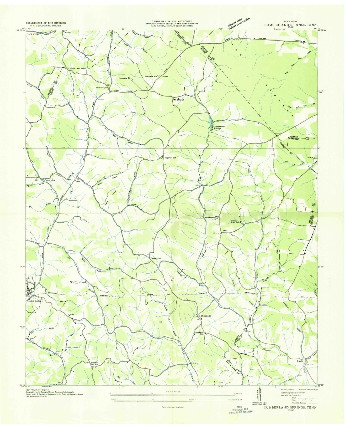
Classic USGS Lynchburg East Tennessee 7.5'x7.5' Topo Map
Couldn't load pickup availability
Historical USGS topographic quad map of Lynchburg East in the state of Tennessee. Map scale may vary for some years, but is generally around 1:24,000. Print size is approximately 24" x 27"
This quadrangle is in the following counties: Bedford, Coffee, Franklin, Moore.
The map contains contour lines, roads, rivers, towns, and lakes. Printed on high-quality waterproof paper with UV fade-resistant inks, and shipped rolled.
Contains the following named places: Adams Cemetery, Allen Cemetery, Awalt, Awalt Bridge, Awalt Cemetery, Bakerstown Division, Bakertown, Baxter Branch, Baxter Hollow, Bedford Hollow, Bobo Cemetery, Bobo Creek, Bobo Hollow, Brandon Hollow, Brown Cemetery, Bryant Cemetery, Calvary Church, Cave Spring Hollow, Chestnut Ridge, Chestnut Ridge Church, Cobb Hollow, Cobbs Steam Mill, Commissioner District 2, Commissioner District 4, Commissioner District 5, County Line Cemetery, Countyline, Cumberland Springs, Cumberland Springs Lake, Cumberland Springs Lake Dam, Cumberland Springs Post Office, Dance Cemetery, Dogtail Creek, Dry Creek, East Moore School, Fall Lick Creek, Faris Spring, Fox Hollow, Good Branch, Gore Cemetery, Gourdneck Hollow, Harper Cemetery, Hatchett Hollow, Hickory Hill, Hickory Hill Baptist Church, Hickory Hill School, Hilltop, Hilltop School, Hix Cemetery, Holiday Hide-A-Way Cabin Site, Hoover Grove Church, Hoover's Grove Cemetery, Hurricane Cemetery, Hurricane Church, Hurricane School, Lost Creek Public Use Area, Lynchburg, Lynchburg Division, Lynchburg Elementary School, Lynchburg Post Office, Maranatha Church, McKnight Cemetery, Metro Lynchburg Moore County Volunteer Fire Department Station 3 Tankersley Ridge, Metro Lynchburg Moore County Volunteer Fire Department Station 4 Motlow College Ledford Mill, Metropolitan Government of Lynchburg Moore County, Millsap Hollow, Moore County, Moore County Courthouse, Moore County High School, Moor-Lin Cabin Site, Motlow State Community College, Mount Ethel Church, Neal Bridge, Old Bethel Cemetery, Patterson Hollow, Pioneer Cemetery, Pleasant Hill, Pleasant Hill Cemetery, Pleasant Hill School, Pleasant Hill United Methodist Church, Possumtrot Ridge, Price Hollow, Prince Branch, Raysville, Raysville Cemetery, Raysville Church, Raysville School, Ridgeville, Ridgeville Cemetery, Ridgeville School, Rittle Hollow, Rocky Branch, Russell Cemetery, Sam Burt Hill, Sanders Causeway, Sanders Hollow, Sawyer Cemetery, Shasteen Cemetery, Smith Chapel, Steed Hollow, Stillhouse Hollow, Stone Creek, Tankersley Branch, Tankersley Ridge, Turkey Creek, Turkey Creek Cemetery, Turkey Creek Church, Turkey Creek Public Use Area, Turkey Creek School, Wanslow Cemetery, Wanslow Hollow, Williams Cemetery, Wiseman Cemetery, Wool Hollow, ZIP Code: 37352