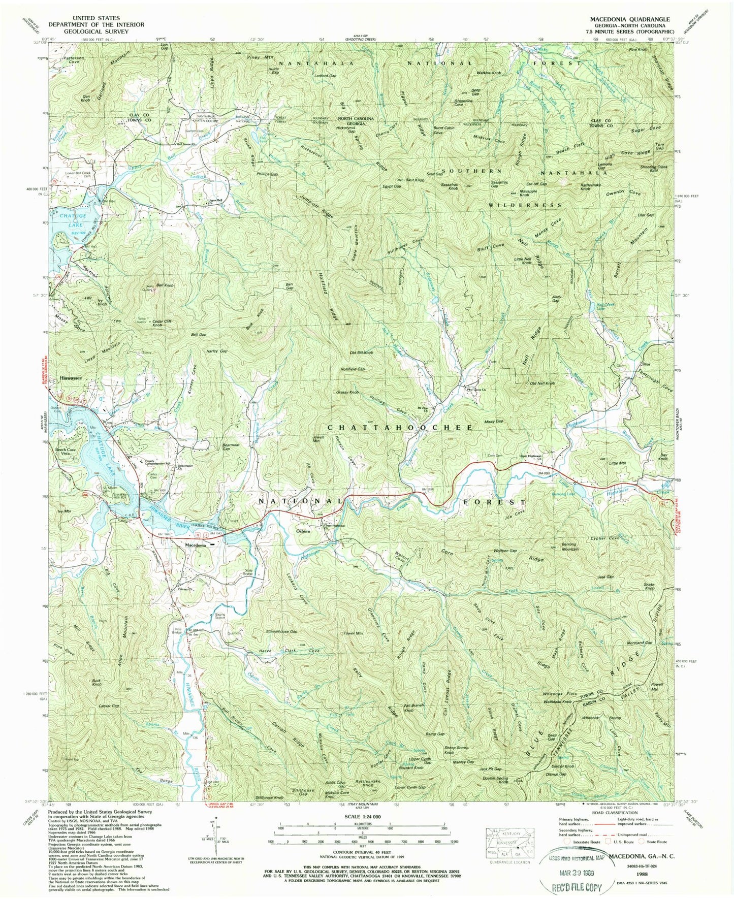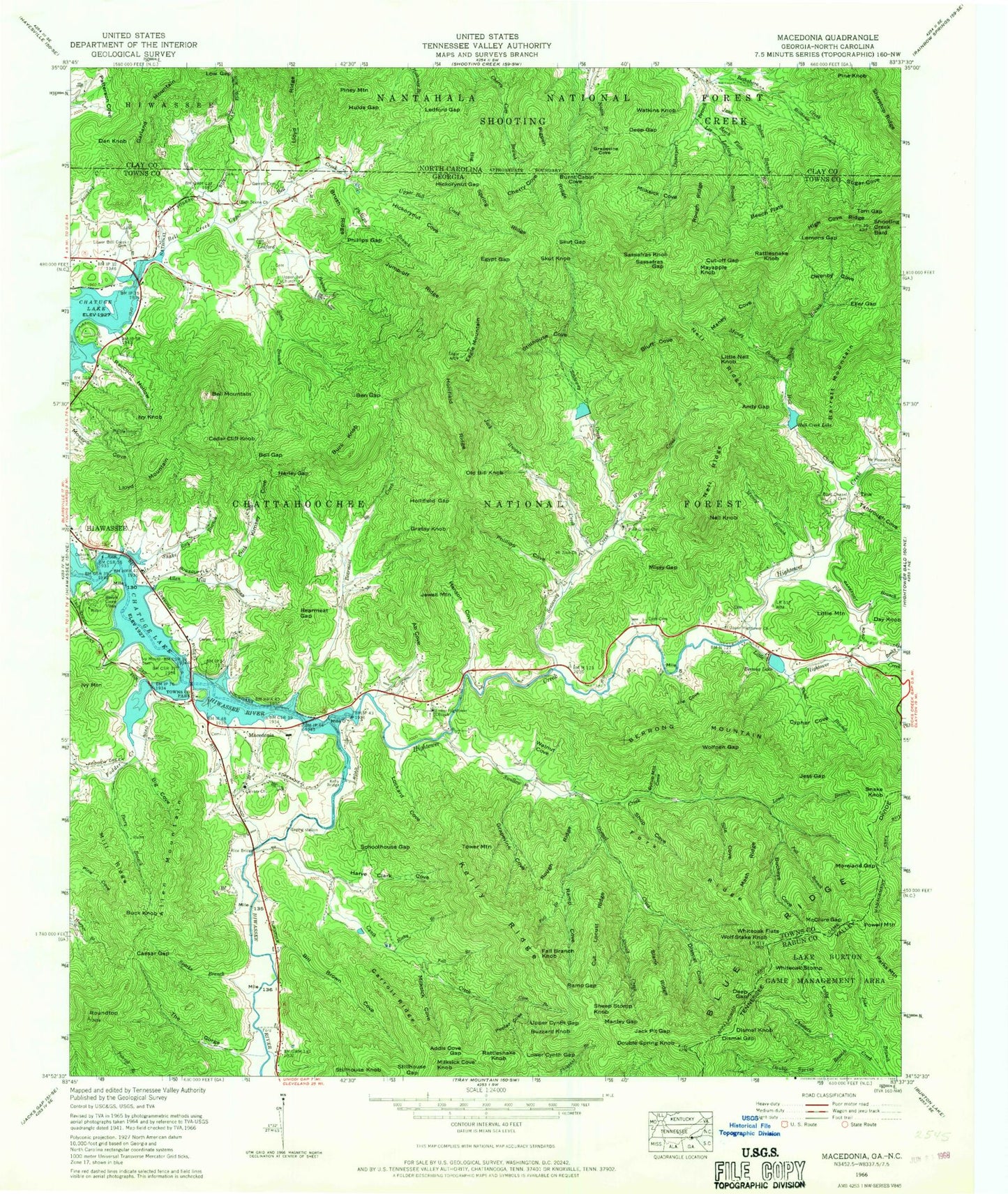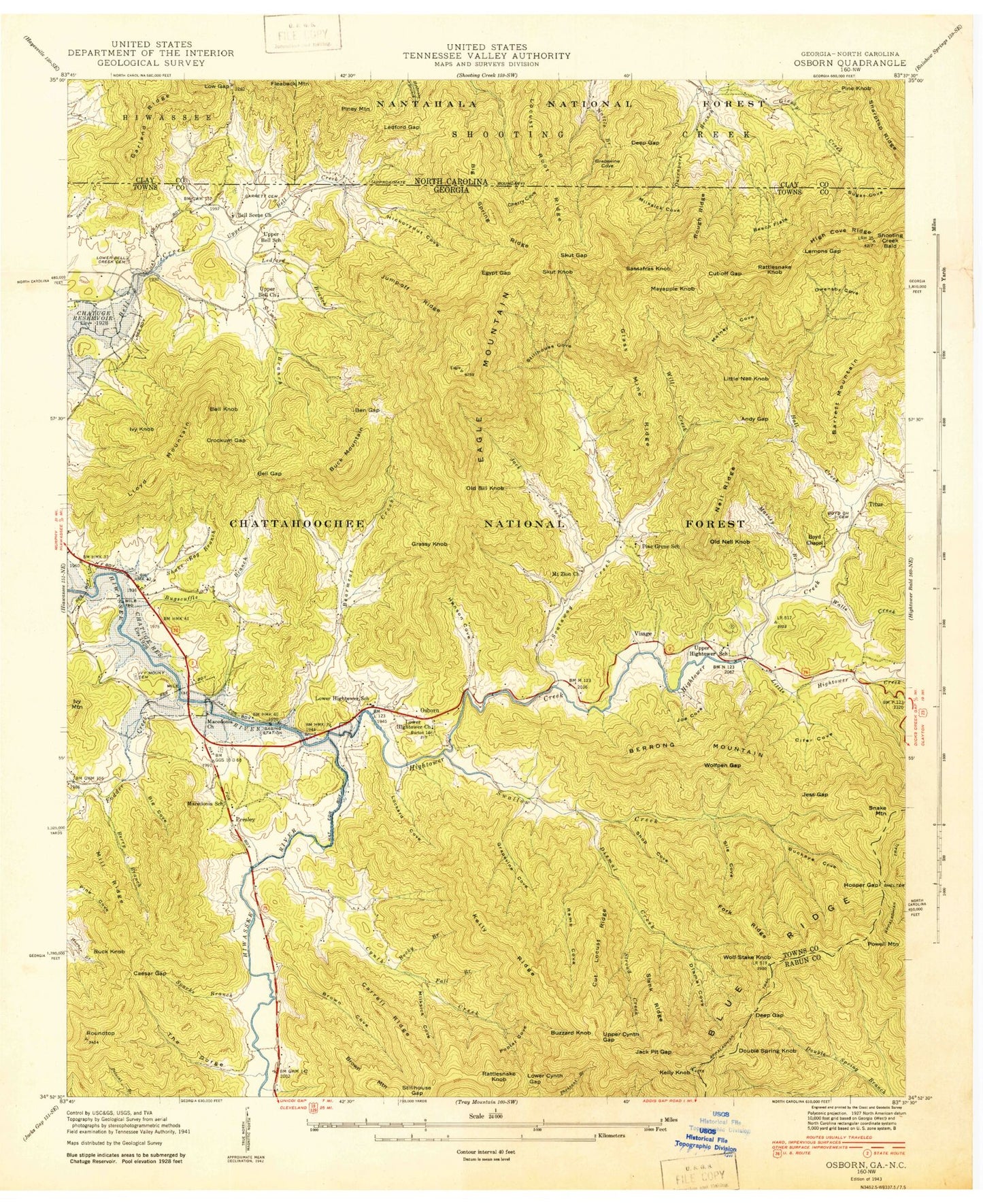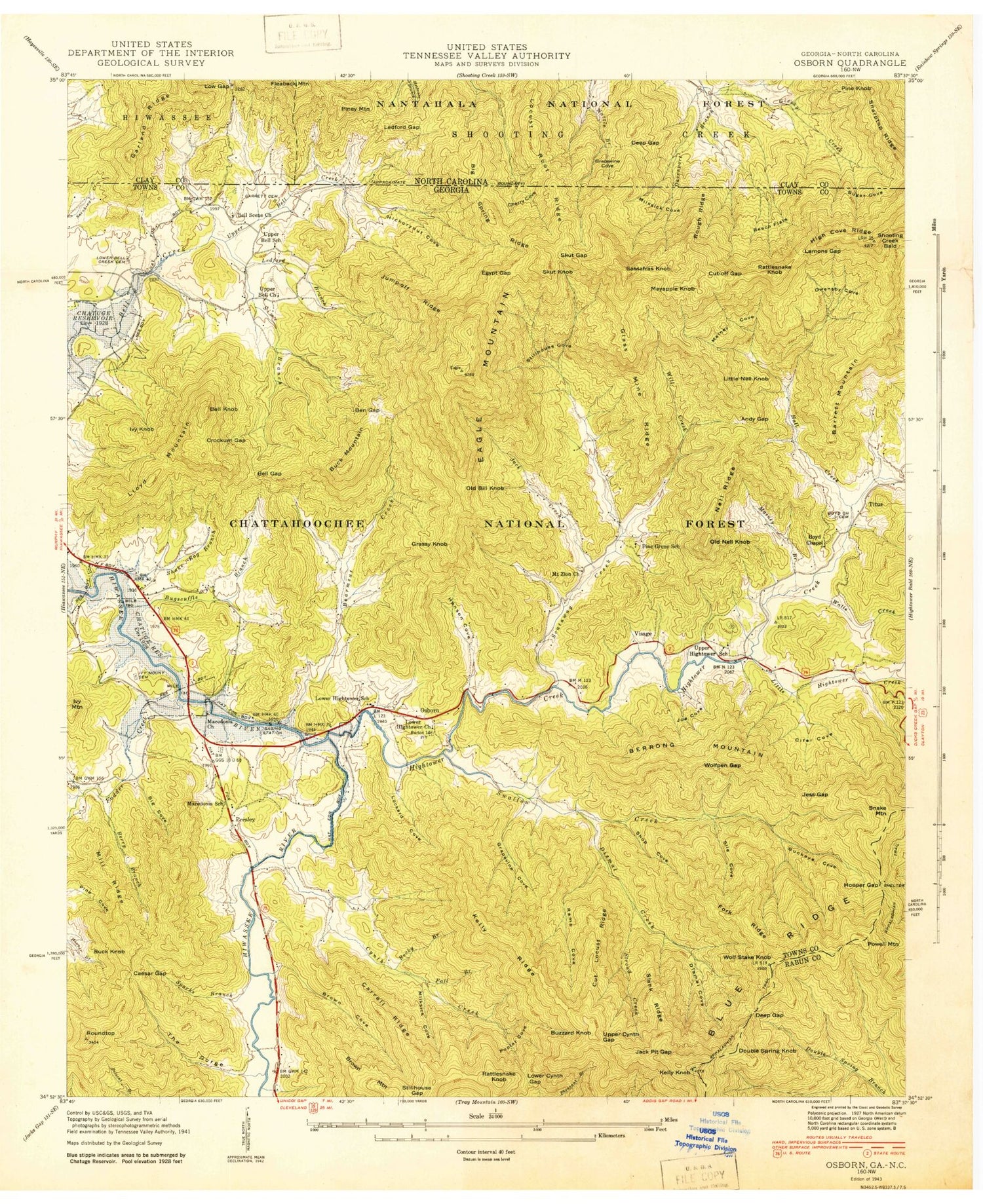
MyTopo
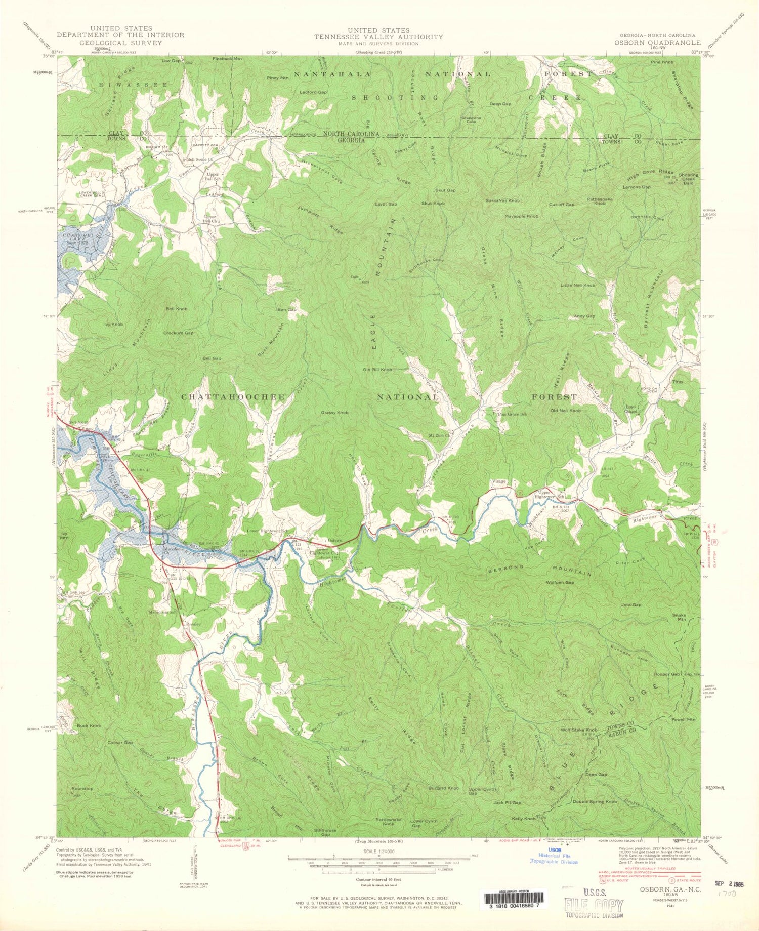
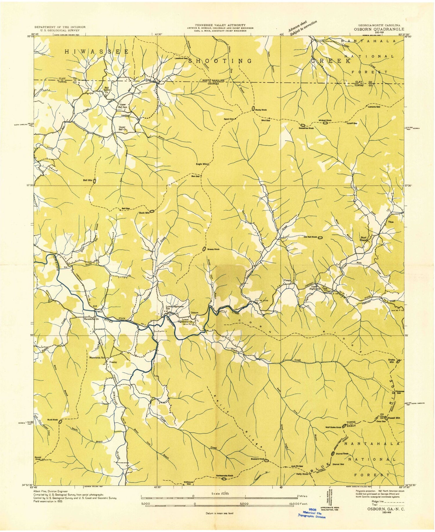
Classic USGS Macedonia Georgia 7.5'x7.5' Topo Map
Couldn't load pickup availability
Historical USGS topographic quad map of Macedonia in the states of Georgia, North Carolina. Typical map scale is 1:24,000, but may vary for certain years, if available. Print size: 24" x 27"
This quadrangle is in the following counties: Clay, Rabun, Towns.
The map contains contour lines, roads, rivers, towns, and lakes. Printed on high-quality waterproof paper with UV fade-resistant inks, and shipped rolled.
Contains the following named places: Ivy Mount Cemetery, Ab Cove, Addis Cove Gap, Allen Mill Creek, Andy Gap, Barret Mountain, Bearmeat Gap, Beech Flats, Beech Flats Branch, Bell Gap, Ben Gap, Berrong Lake, Berrong Mountain, Berry Branch, Big Cove, Big Spring Ridge, Bill Brown Cove, Bluff Cove, Boyd Chapel Cemetery, Brush Ridge, Buckeye Cove, Burnt Cabin Cove, Caesar Gap, Carroll Ridge, Carter Cemetery, Cave Branch, Cherry Cove, Corn Cemetery, Cut Locust Ridge, Cut-off Gap, Cynth Creek, Cypher Cove, Deep Gap, Dismal Cove, Dismal Creek, Dismal Gap, Double Spring Branch, Double Spring Knob, Eagle Mountain, Egypt Gap, Eller Gap, Fall Branch, Fall Branch, Fall Branch, Fork Ridge, Garrett Cemetery, Grapevine Cove, Hall Creek, Harve Clark Cove, Henson Cove, Hickorynut Cove, Hickorynut Gap, High Cove Ridge, Hollifield Gap, Hollifield Ridge, Jack Hooper Creek, Jack Pit Gap, Jane Rabun Branch, Jess Gap, Joe Cove, Jump-off Ridge, Kelly Bridge, Kelly Ridge, Kimsey Cove, Ledford Branch, Lee Ledford Branch, Lemons Gap, Little Hightower Creek, Lockard Cove, Lolly Cove, Lovell Branch, Lower Bell Creek Cemetery, Lower Cynth Gap, Lower Hightower Church, Maney Branch, Maney Branch, Maney Cove, Manley Gap, Mash Ridge, Milksick Cove, Milksick Cove, Mill Ridge, Missy Gap, Moreland Gap, Mossy Cove, Mount Pleasant Church, Mount Zion Church, Nell Ridge, Osborn Cemetery, Owenby Cove, Phillips Branch, Phillips Gap, Walls Creek, Pigpen Ridge, Pine Cove, Pine Grove Church, Poplar Cove, Raccoon Hollow, Ramp Cove, Ramp Gap, Rice Bridge, Rocky Branch, Rocky Branch, Rough Ridge, Rough Ridge, Round Top, Sassafras Gap, Scataway Creek, Schoolhouse Gap, Shoal Branch, Shook Branch, Shooting Creek Bald, Shop Cove, Sile Cove, Sims Branch, Skut Gap, Slank Ridge, Sparks Branch, Stillhouse Cove, Stillhouse Gap, Stroud Creek, Sugar Cove, Swallow Creek, Syrup Mill Cove, Tantrough Cove, The Gorge, Tom Gap, Towns County High School, Towns County Park (historical), Upper Bell Church, Upper Bell Creek, Upper Cynth Gap, Upper Hightower Church, Walnut Cove, Will Creek, Wolfpen Gap, Osborn, Deliverance Church, Wolfstake Knob, Whiteoak Flats, McClure Gap, Corn Ridge, Macedonia School, Towns County Comprehensive School, Lower Hightower School, Upper Hightower School, Allen Mountain, Beech Cove Vista, Bell Knob, Buck Knob, Buck Knob, Buzzard Knob, Cedar Cliff Knob, Day Knob, Dismal Knob, Fall Branch Knob, Grassy Knob, Harley Gap, Ivy Knob, Jewell Mountain, Little Mountain, Little Nell Knob, Lloyd Mountain, Macedonia, Mayapple Knob, Milksick Cove Knob, Old Nell Knob, Old Bill Knob, Powell Mountain, Rattlesnake Knob, Rattlesnake Knob, Sassafras Knob, Sheep Stomp Knob, Skut Knob, Snake Knob, Stillhouse Knob, Titus, Tower Mountain, Whiteoak Stomp, Eagle Mountain Trout Farm Lake Dam, Eagle Mountain Reservoir, Scataway Creek Watershed Number 18 Dam, Scataway Creek Watershed Number 18 L, Eagle Mountain Trout Farm Lake Dam, Eagle Mountain Trout Farm Lake, Berrong Lake Dam, Hightower Creek Ws Struct Number 25 Dam, Hall Creek Lake, Boyd Chapel (historical), Lower Hightower Cemetery, Macedonia Baptist Church, Macedonia Cemetery, Macedonia Community School (historical), Macedonia School (historical), Pine Grove School (historical), Presley, Towns County, Upper Bell School (historical), Upper Hightower Cemetery, Bearmeat Creek, Bell Scene Church, Calvary Church, Fodder Creek, Hightower Creek, Shake Rag Branch, Burnt Cabin Cove, Milksick Cove, Rocky Knob, Visage (historical), Hiawassee Division, Towns County Middle School, Towns County Elementary School, Towns County Fire and Rescue Station 4, Cherry Cove, Deep Gap, Grapevine Cove, Hulda Gap, Ledford Gap, Lloyd Ridge, Low Gap, Patterson Cove, Stillhouse Branch, Sugar Cove, Dan Knob, Garland Mountain, Pine Knob, Piney Mountain, Watkins Knob, Ivy Mount Cemetery, Ab Cove, Addis Cove Gap, Allen Mill Creek, Andy Gap, Barret Mountain, Bearmeat Gap, Beech Flats