
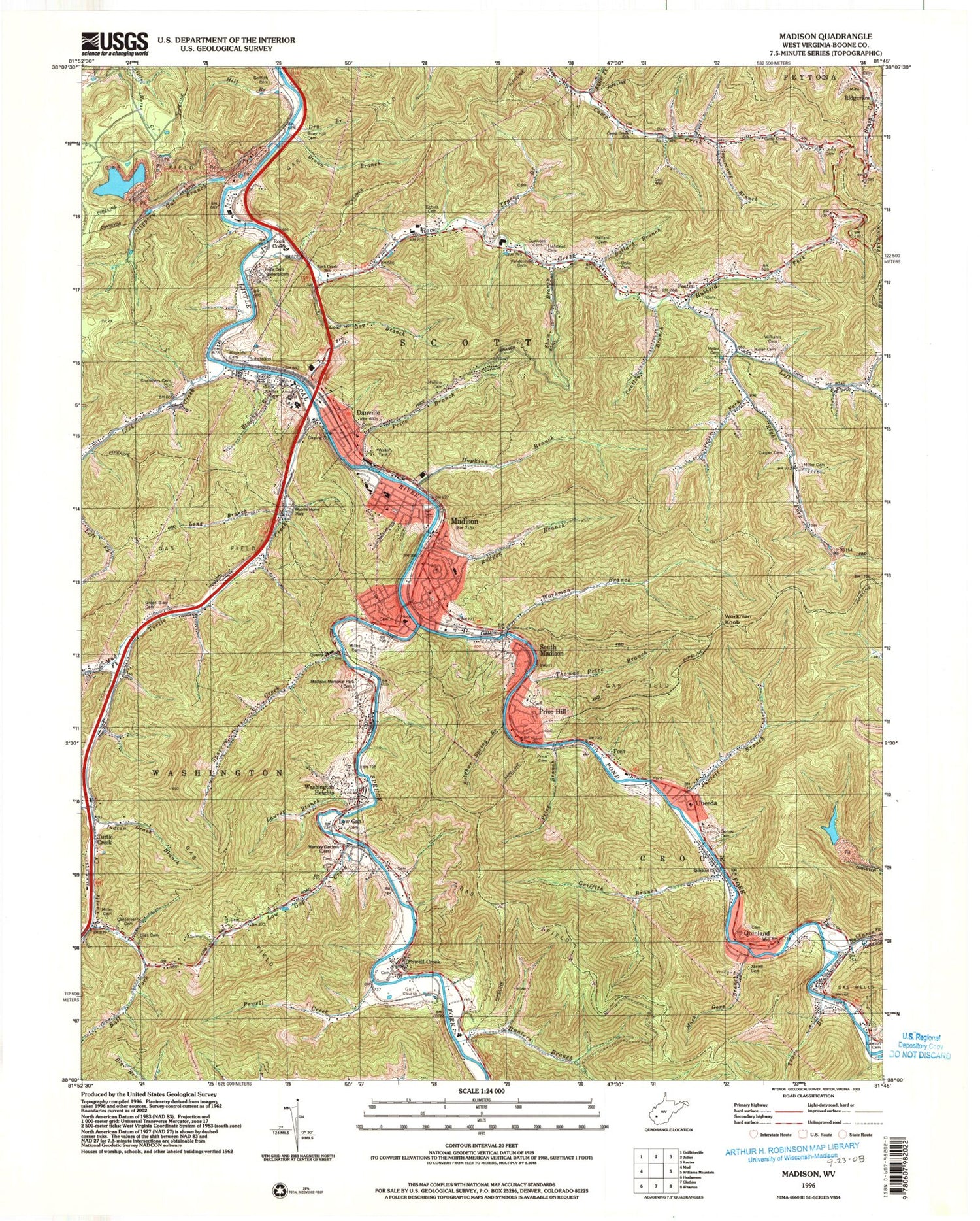
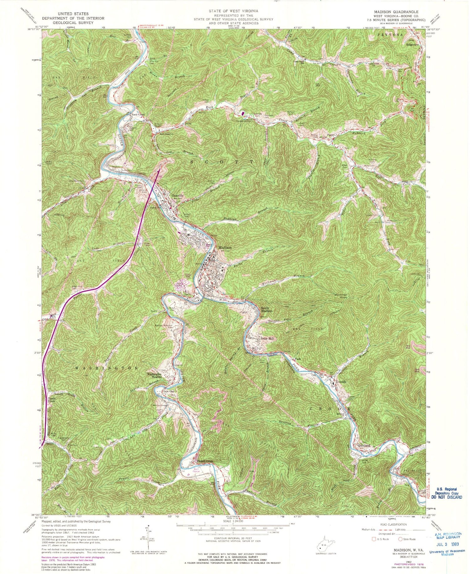
MyTopo
Classic USGS Madison West Virginia 7.5'x7.5' Topo Map
Couldn't load pickup availability
Historical USGS topographic quad map of Madison in the state of West Virginia. Map scale may vary for some years, but is generally around 1:24,000. Print size is approximately 24" x 27"
This quadrangle is in the following counties: Boone.
The map contains contour lines, roads, rivers, towns, and lakes. Printed on high-quality waterproof paper with UV fade-resistant inks, and shipped rolled.
Contains the following named places: Ball Fork, Ballard Branch, Ballard Cemetery, Benjamin Price Bridge, Bias Cemetery, Boone - Madison Public Library, Boone Career and Technical Center, Boone County Ambulance Authority Medic Station 15, Boone County Ambulance Authority Medic Station 20, Boone County Courthouse, Boone County Sheriff's Office, Boone Memorial Hospital, Boone Memorial Park, Brookview Elementary School, Brown Branch, Browns Branch, Camp Creek Church, Camp Creek School, Canterberry Cemetery, Cantley Branch, Chambers Cemetery, City of Madison, Cooper Cemetery, Danville, Danville Bridge, Danville Elementary School, Danville Police Department, Danville Post Office, Danville Volunteer Fire Department, District 3, Dolin Cemetery, Dry Branch, Easter Fork, Echols Cemetery, Foch, Foster, Foster Post Office, Gomez Cemetery, Green Bias Cemetery, Griffith Branch, Griffith Cemetery, Gunnoes Cemetery, Haddleton, Halstead Cemetery, Hill Branch, Hopkins, Hopkins Branch, Hopkins Cemetery, Hubbard Fork, Hunters Branch, Indian Grave Branch, Jarrell Branch, Jarrell Cemetery, Jill Micaah Hess Bridge, Laurel Branch, Lawson Cemetery, Left Fork Lick Creek, Left Fork Rock Creek, Lick Creek, Long Branch, Low Gap, Low Gap Branch, Low Gap Creek, LT Darwin K Kyle Memorial Bridge, Mack Gore Branch, Madison, Madison Elementary Preschool Annex, Madison Elementary School, Madison Memorial Park, Madison Middle School, Madison Police Department, Madison Post Office, Madison Volunteer Fire Department, Memory Gardens, Miller Cemetery, Mud Fork, Mullins Cemetery, Olive Branch Missionary Baptist Church, Pedee Fork, Perdue Cemetery, Pond Fork, Powell Creek, Price Branch, Price Cemetery, Price Hill, Quinland, Quinland Church, Raccoon Branch, Right Fork Rock Creek, Riley Hill Cemetery, Riverview Country Club Golf Course, Robinson Creek, Rock Creek, Rock Creek School, Rucker Branch, Scott High School, Shaw Branch, Slippery Gut Branch, South Madison, Sparrow Creek, Spruce Fork, Sugarcamp Branch, Sulphur Spring Branch, Thomas Price Branch, Town of Danville, Trace Branch, Turtle Creek, Turtle Creek Post Office, Turtletown, Uneeda, Uneeda Grade School, Uneeda Post Office, Van Camp, Vandelinde Cemetery, Washington Heights, West Virginia Division of Forestry Boone County Field Office, West Virginia State Police Troop 5, Williams Cemetery, Workman Branch, Workman Knob, WZAC-AM (Madison), WZAC-FM (Danville), ZIP Codes: 25081, 25130, 25205


