MyTopo
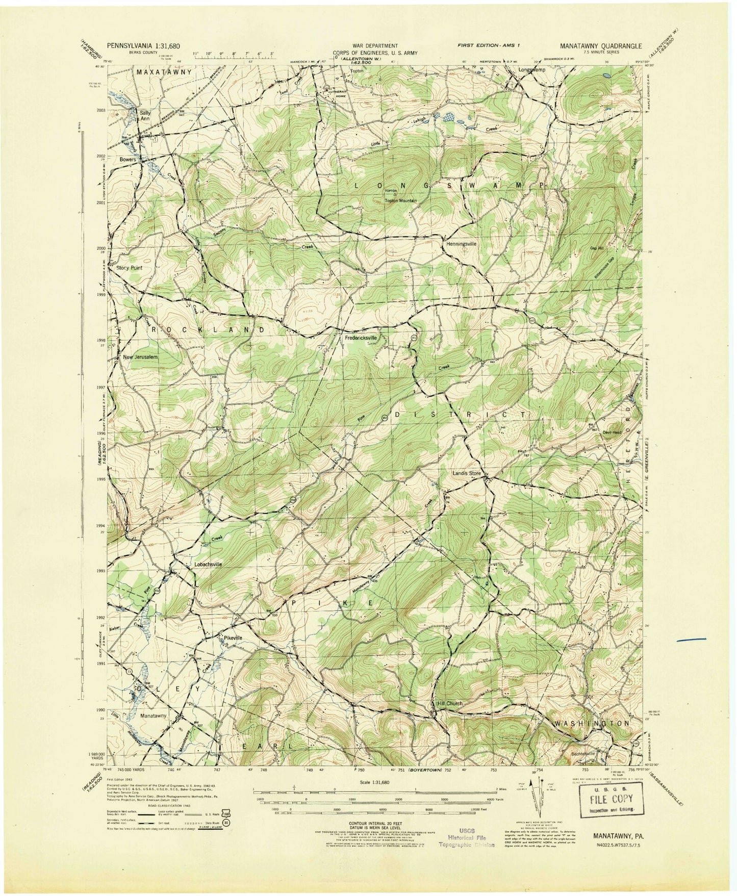
Classic USGS Manatawny Pennsylvania 7.5'x7.5' Topo Map
Couldn't load pickup availability
Historical USGS topographic quad map of Manatawny in the state of Pennsylvania. Typical map scale is 1:24,000, but may vary for certain years, if available. Print size: 24" x 27"
This quadrangle is in the following counties: Berks.
The map contains contour lines, roads, rivers, towns, and lakes. Printed on high-quality waterproof paper with UV fade-resistant inks, and shipped rolled.
Contains the following named places: Bieber Creek, Bowers, Bowers Park, Bush School, Devil Head, Drumhellers School, Fredericksville Chapel, Funks School, Gap Hill, Herzog School, Hill Church, Landis Store, Landis Well School, Little Manatawny Creek, Little Sacony Creek, Lobachs School, Lobachsville, Longswamp, Lower Longswamp, Manatawny, New Jerusalem, Pikeville, Pine Creek, Pleasantville Park, Rittenhouse Gap, Roebuck School, Rupperts School, Saint Pauls Church, Topton Mountain, Weller Cemetery, West Branch Pine Creek, Dryville, Oysterville Creek, Area 52 Airport, Oreville School, Mountain Marys Grave, WBYO-FM (Boyertown), Five Points, Fredericksville, Henningsville, Longsdale, Pilgerts, Pine Waters, Sally Ann, Doe Mountain Ski Area, Diversion Dam, Mensch Mill Dam, Township of District, Township of Longswamp, Township of Pike, Township of Rockland, Stone Roll Creek, Corn Church Creek, Dieners Daal Creek, Drumheller School Creek, Heilig School Creek, Moser Run, Mountain Mary Creek, Bethel Romanian Independent Pentecostal Church, Brandywine Community Library, Brandywine Heights Middle School, Christ DeLong United Church of Christ, Union Cemetery, Community Rod and Gun Club, District Township Garage, District Township Municipal Building, District-Topton Elementary Center, Longswamp Union Cemetery, Longswamp United Church of Christ, Pike Township Building, Pleasantville Covered Bridge, Pleasantville Evangelical Church, Rittenhouse Gap, Rockland Elementary School, Saint John-Hill United Church of Christ, Saint Pauls Lutheran Cemetery, Mensch Mill Conference and Retreat Center, Morning Star Fellowship, Gordon Park, Haas Field, Hill Church Union Cemetery, The Bridge Inn, The Inn at Bally Spring Farm, Topton Lutheran Home, Chimney Rocks, Bowers Census Designated Place, Martin Stone Quarries, Show Top Farms, Glen Run, Bowers Post Office, Hoch Family Cemetery, Weidner Number 2 Cemetery, Jacob Keim Farmstead Family Burial Ground, Pleasantville Union Cemetery, Bieber Creek, Bowers, Bowers Park, Bush School, Devil Head, Drumhellers School, Fredericksville Chapel, Funks School, Gap Hill, Herzog School, Hill Church, Landis Store, Landis Well School, Little Manatawny Creek, Little Sacony Creek, Lobachs School, Lobachsville, Longswamp, Lower Longswamp, Manatawny, New Jerusalem, Pikeville, Pine Creek, Pleasantville Park, Rittenhouse Gap, Roebuck School, Rupperts School, Saint Pauls Church, Topton Mountain, Weller Cemetery, West Branch Pine Creek, Dryville, Oysterville Creek, Area 52 Airport, Oreville School, Mountain Marys Grave, WBYO-FM (Boyertown), Five Points, Fredericksville, Henningsville, Longsdale, Pilgerts, Pine Waters, Sally Ann, Doe Mountain Ski Area, Diversion Dam, Mensch Mill Dam, Township of District, Township of Longswamp, Township of Pike, Township of Rockland, Stone Roll Creek, Corn Church Creek, Dieners Daal Creek, Drumheller School Creek, Heilig School Creek, Moser Run, Mountain Mary Creek, Bethel Romanian Independent Pentecostal Church, Brandywine Community Library, Brandywine Heights Middle School, Christ DeLong United Church of Christ, Union Cemetery, Community Rod and Gun Club, District Township Garage, District Township Municipal Building, District-Topton Elementary Center, Longswamp Union Cemetery, Longswamp United Church of Christ, Pike Township Building, Pleasantville Covered Bridge, Pleasantville Evangelical Church, Rittenhouse Gap, Rockland Elementary School, Saint John-Hill United Church of Christ, Saint Pauls Lutheran Cemetery, Mensch Mill Conference and Retreat Center, Morning Star Fellowship, Gordon Park, Haas Field, Hill Church Union Cemetery, The Bridge Inn, The Inn at Bally Spring Farm, Topton Lutheran Home, Chimney Rocks, Bowers Census Designated Place, Martin Stone Quarries, Show Top Farms, Glen Run, Bowers Post Office, Hoch Family Cemetery, Weidner Number 2 Cemetery, Jacob Keim Farmstead Family Burial Ground, Pleasantville Union Cemetery