MyTopo
USGS Classic Many Glacier Montana 7.5'x7.5' Topo Map
Couldn't load pickup availability
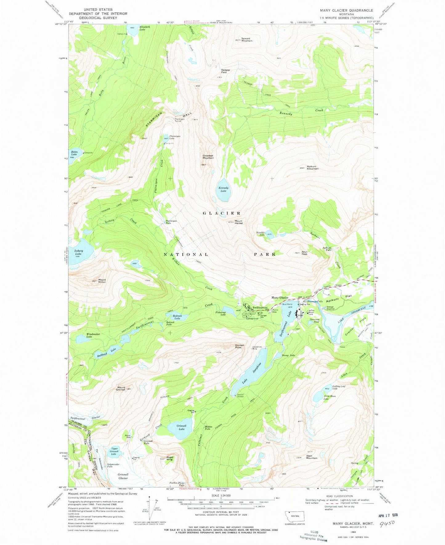
Historical USGS topographic quad map of Many Glacier in the state of Montana. Scale: 1:24000. Print size: 24" x 27"
This quadrangle is in the following counties: Flathead, Glacier.
The map contains contour lines, roads, rivers, towns, lakes, and grids including latitude / longitude and UTM / MGRS. Printed on high-quality waterproof paper with UV fade-resistant inks.
Contains the following named places: Apikuni Flat, Allen Creek, Allen Mountain, Altyn Peak, Angel Wing, Apikuni Falls, Apikuni Mountain, Cataract Creek, Cracker Flats, Crowfeet Mountain, Falling Leaf Lake, Fishercap Lake, Governor Pond, Grinnell Creek, Grinnell Falls, Grinnell Glacier, Grinnell Glacier Trail, Grinnell Lake, Grinnell Point, Mount Grinnell, Helen Lake Trail, Mount Henkel, Hidden Falls, Iceberg Creek, Iceberg Lake, Iceberg Lake Trail, Josephine Mine, Lake Josephine, Kennedy Lake, Many Glacier, Natahki Lake, Piegan Pass Trail, Ptarmigan Creek, Ptarmigan Falls, Ptarmigan Lake, Ptarmigan Trail, Ptarmigan Tunnel, Ptarmigan Wall, Redgap Pass, Redgap Pass Trail, Redrock Falls, Redrock Lake, Salamander Falls, Seward Mountain, Snow Moon Lake, Stump Lake, Swiftcurrent, Swiftcurrent Falls, Swiftcurrent Glacier, Swiftcurrent Lake, Swiftcurrent Pass Trail, The Garden Wall, The Salamander Glacier, Upper Grinnell Lake, Wilbur Creek, Mount Wilbur, Windmaker Lake, Oastler Shelter, Feather Plume Falls, Bullhead Lake, 35N16W12DCCA01 Well, 35N16W12CBBB01 Well, 35N16W12CCAB01 Well, 35N16W12CACC01 Well, Swiftcurrent Post Office (historical), Harrisville (historical), Many Glacier Campground