MyTopo
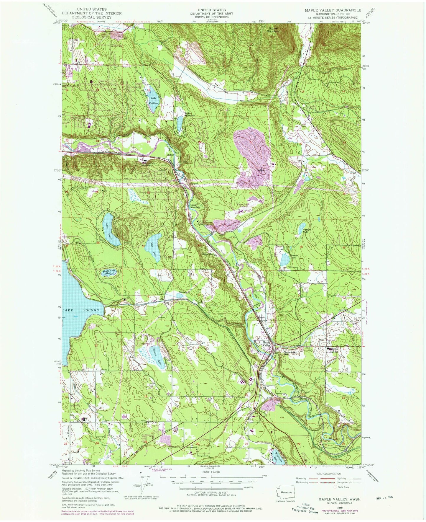
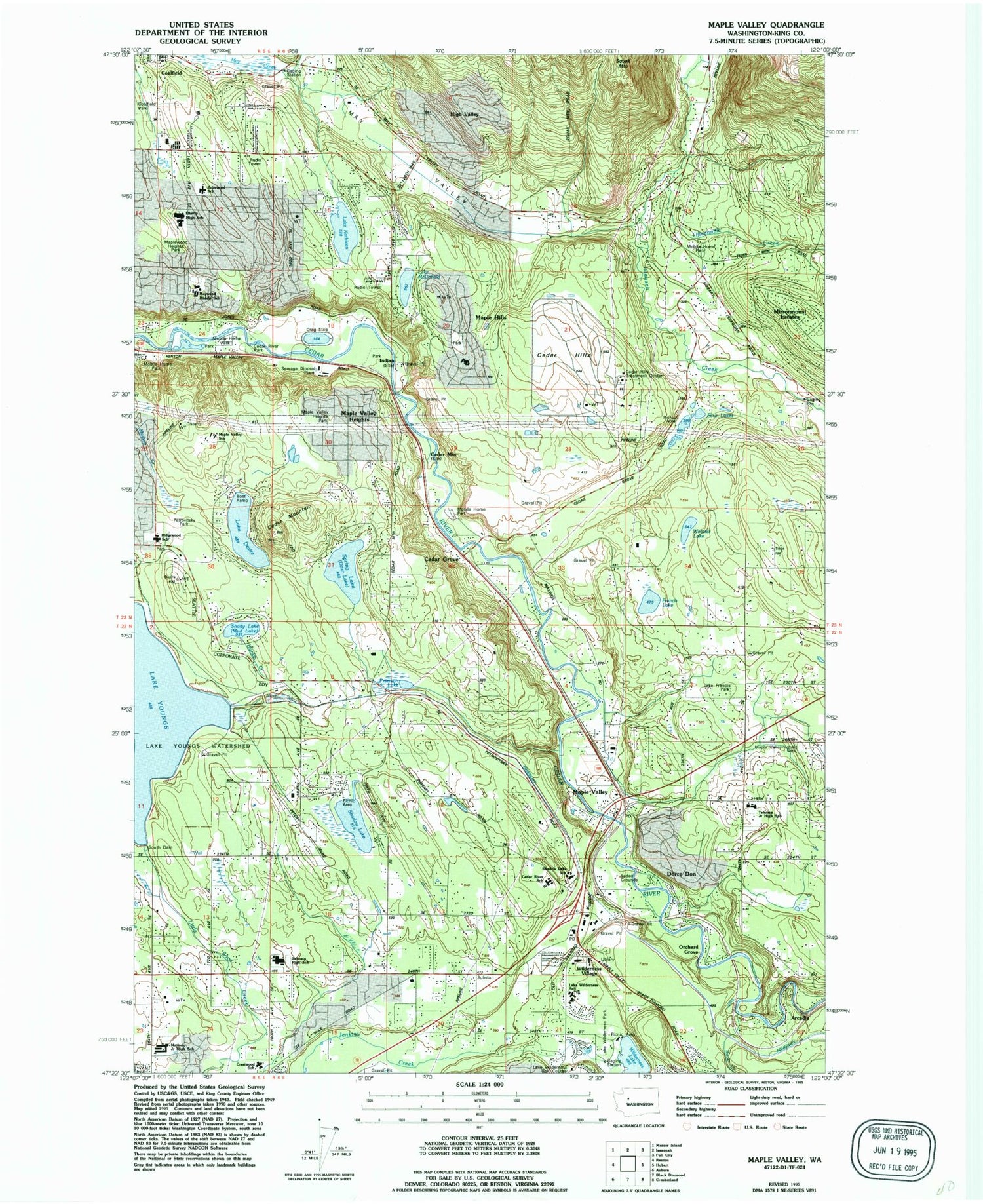
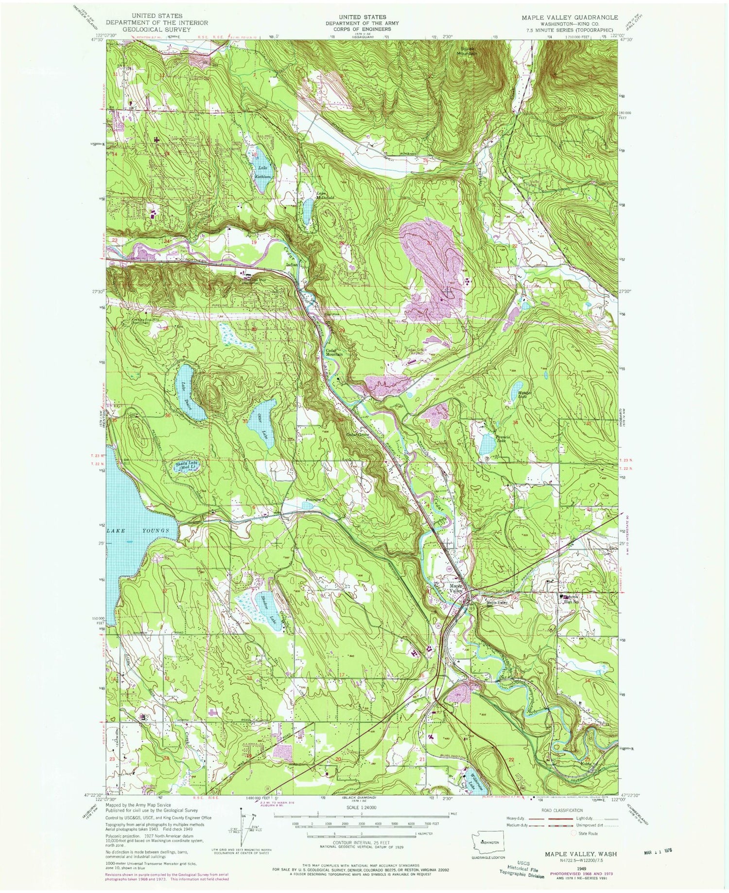
Classic USGS Maple Valley Washington 7.5'x7.5' Topo Map
Couldn't load pickup availability
Historical USGS topographic quad map of Maple Valley in the state of Washington. Typical map scale is 1:24,000, but may vary for certain years, if available. Print size: 24" x 27"
This quadrangle is in the following counties: King.
The map contains contour lines, roads, rivers, towns, and lakes. Printed on high-quality waterproof paper with UV fade-resistant inks, and shipped rolled.
Contains the following named places: Fire King Coal Mine, Francis Lake, Indian, Indian Coal Mine, Lake Kathleen, Maple Valley, Maple Valley High School, Peterson Lake, Shadow Lake, Shady Lake, Webster Lake, Lake Youngs, Cedar Hills Treatment Center, Rainier Christian Schools, Maple Valley Heights, Four Lakes, Cedar Mountain, Honey Creek, Lake Youngs Watershed, Tahoma Senior High School, Hobart Maple Valley Cemetery, Rock Creek, Arcadia, Cedar Hills, Wilderness Village, Dorre Don, Orchard Grove, Maple Hills, High Valley, Lake Francis Park, Spring Lake, Tahoma Middle School, Cedar Grove, Cedar Mountain, Noble, Lake Wilderness Resort, Squak Mountain, Wilderness, Atkinson, Lake Desire, Lake McDonald, South Dam, Four Corner Square, Tahoma, Liberty High School, Briarwood Elementary School, Maywood Middle School, Maple Hills Elementary School, Mattson Middle School, Crestwood Elementary School, Fifteenmile Creek, Mirrormount Estates, Cedar River Elementary School, Shadow Lake Elementary School, Lake Wilderness Elementary School, Meridian Heights, Lake Wilderness Park, Lake Youngs Inlet Dam, Youngs Lake Old Inlet Dam (historical), Cedar Grove Airpark (historical), East Renton Highlands, Lions Run, East Renton Highlands Census Designated Place, Maple Heights-Lake Desire Census Designated Place, Lake Desire, Cedar River Middle School, Northwood Middle School, Ridgewood Elementary School, Russell Ridge Center School, Shadow Lake Census Designated Place, Cedar Hills Landfill, Kindercare Learning Center 1421, Mountainside School, Tiger Mountain Mobile Home Park, Cedar Grove Mobile Home Park, May Valley Manor Mobile Home Park, Riverbend Mobile Home Park, Valley View Mobile Home Park, Jones Road Bridge, Links at Olson Mansion, Riverbend Recreational Vehicle Park, Alliance Bible Church, Maple Valley Presbyterian Church, Sanatan Dharma Temple and Cultural Center, Saint Sava Serbian Orthodox Church, Shepherd of the Valley Lutheran Church, Taylor Creek Church, Maple Valley Church of the Nazarene, Saint Georges Episcopal Church, The Church of Jesus Christ of Latter Day Saints, King County Fire Protection District 43 Maple Valley Fire and Life Safety Station 81, King County Fire Protection District 43 Maple Valley Fire and Life Safety Station 84, King County Fire Protection District 43 Maple Valley Fire and Life Safety Storage Facility, Eastside Fire and Rescue Battalion 3 Station 79 Maple Hills, Tahoma National Cemetery, Maple Valley Police Department, King County Sheriff Maple Valley, Maple Valley Post Office