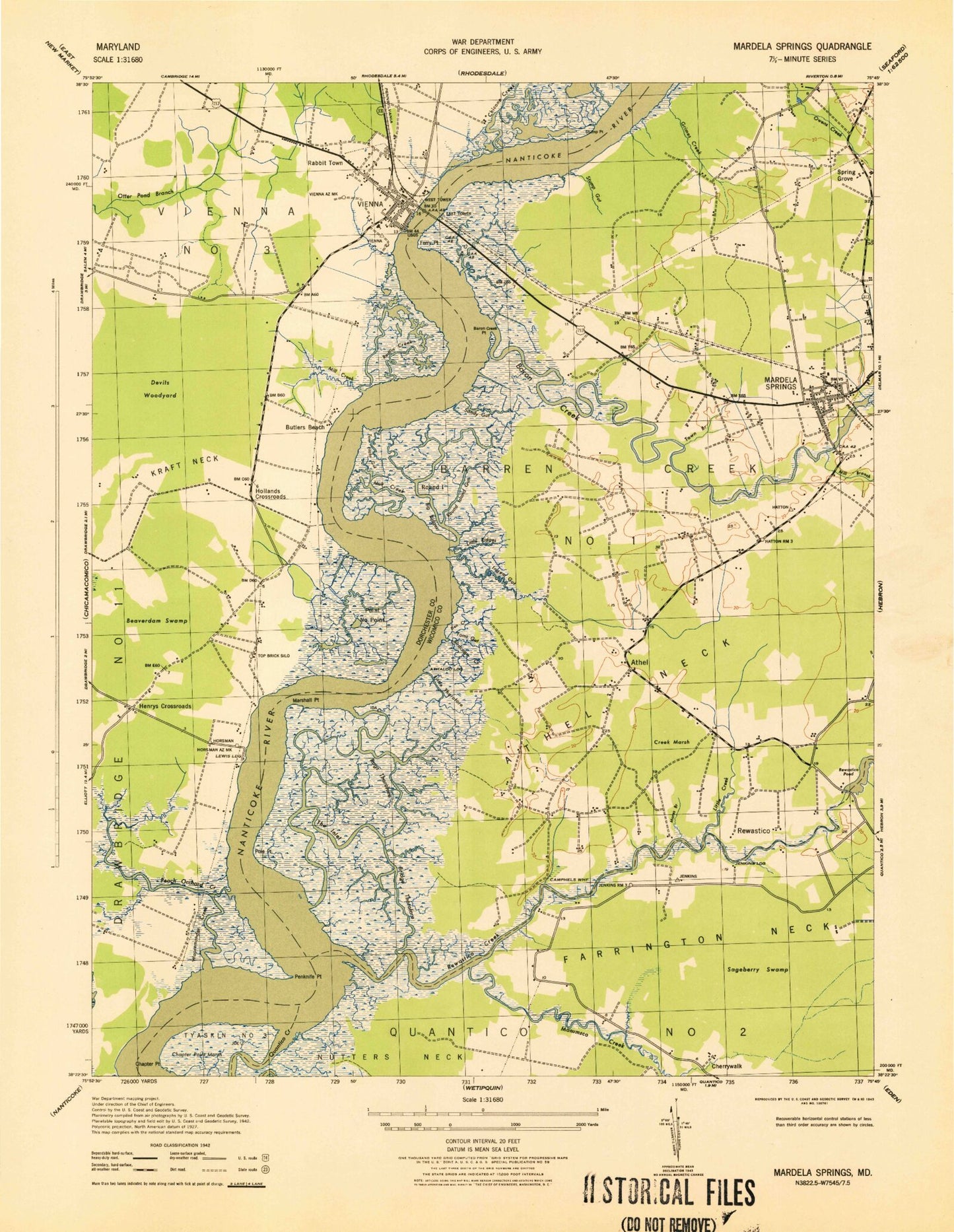
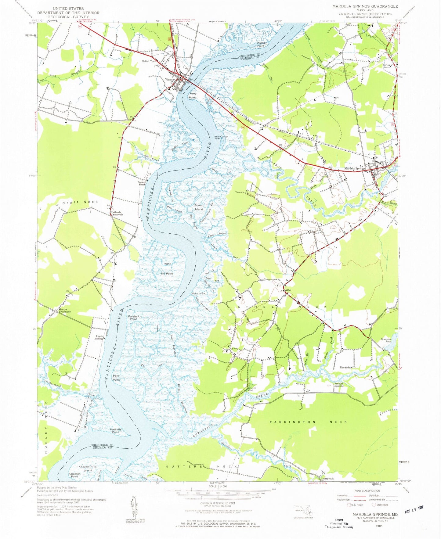
MyTopo
Classic USGS Mardela Springs Maryland 7.5'x7.5' Topo Map
Couldn't load pickup availability
Historical USGS topographic quad map of Mardela Springs in the state of Maryland. Map scale may vary for some years, but is generally around 1:24,000. Print size is approximately 24" x 27"
This quadrangle is in the following counties: Dorchester, Wicomico.
The map contains contour lines, roads, rivers, towns, and lakes. Printed on high-quality waterproof paper with UV fade-resistant inks, and shipped rolled.
Contains the following named places: Allanbank Nursery, Athaloo Landing, Athol, Athol Neck, Barren Creek, Barren Creek Field, Barren Creek Point, Barren Creek Presbyterian Church, Barren Creek Springs Presbyterian Cemetery, Beaverdam Swamp, Big Ridges, Birdcage Creek, Bradleys Creek, Bridge Creek, Bridge Thorofare, Butlers Beach, Camp Merrill, Camphels Wharf, Chapter Point, Chapter Point Marsh, Cherry Walk Estates, Cherrywalk, Chicone Creek, Creek Marsh, Den Creek, Devils Woodyard, District 1 Barren Creek, Emmanuel Church, Farrington Neck, Ferry Point, First Baptist Church, First Pilgrim Holiness Church, Governor Hicks House, Halfe Point, Henrys Crossroads, Henrys Crossroads School, Hollands Crossroads, Hurley Neck, Ingem Gut, Jenkins Landing, Kraft Neck, Lewis Landing, Little Creek, Little Ridges, Little Thorofare, Manumsco Creek, Maple Shade School, Mardela Springs, Mardela Springs Park, Mardela Springs Post Office, Mardela Springs Volunteer Fire Department Station 9, Mardella Springs Town Hall, Mares Branch, Marshall Point, Mill Branch, Mill Creek, Mount Nebo United Methodist Church, Mount Pleasant Church, Muir Creek, Oak Terrace Trailer Park, Peachorchard Creek, Penknife Point, Point No Point, Pole Point, Quantico Census Designated Place, Quantico Creek, Rabbit Town, Rags Thorofare, Redfin Creek, Rewastico, Rewastico Creek, Rewastico Pond Dam, Round Island, Round Island Gut, Sageberry Swamp, Saint Pauls Episcopal Church, Sandy Gut, Spring Grove, Stump Gut, Stump Point, The Customs House, The Ferry House, The Inlet, Tom Fitch Gut, Tom Fitchs Gut, Toms Gut, Town Branch, Town of Mardela Springs, Town of Vienna, Vienna, Vienna Cemetery, Vienna Elementary School, Vienna Post Office, Vienna United Methodist Church, Vienna Volunteer Fire Company Station 11, Wapremander Creek, Wesleyan Church, ZIP Code: 21837