MyTopo
Classic USGS Marion Virginia 7.5'x7.5' Topo Map
Couldn't load pickup availability
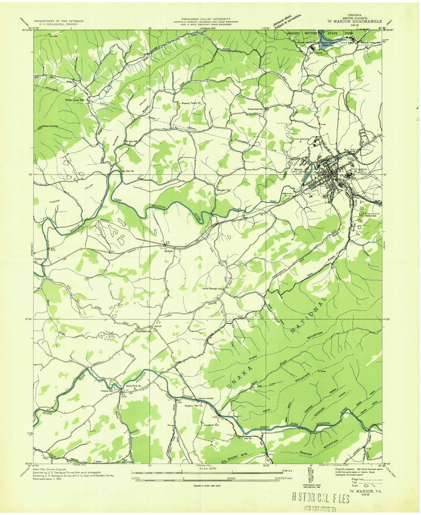
Historical USGS topographic quad map of Marion in the state of Virginia. Map scale may vary for some years, but is generally around 1:24,000. Print size is approximately 24" x 27"
This quadrangle is in the following counties: Smyth.
The map contains contour lines, roads, rivers, towns, and lakes. Printed on high-quality waterproof paper with UV fade-resistant inks, and shipped rolled.
Contains the following named places: Adwolf, Adwolf Census Designated Place, Adwolfe Volunteer Fire Department, Allen Cemetery, Allen Hollow, Baker Hollow, Barton Branch, Barton Mountain, Buller Bass Hatchery, Camp Cedars, Carnegie High School, Christ Episcopal Church, Church of God, Church of God of Prophecy, Clyburn Hollow, Cooperative Center for Exceptional Children, Crouse Cemetery, Deans Branch, Dunford Ridge, Ebenezer Cemetery, Ebenezer Church, Ebenezer Lutheran Church, First Baptist Church, First Church of the Nazarene, First United Methodist Church, Gethsemane Christian Academy, Grace United Methodist Church, Greenwood Church, Grey Rocks Plaza Shopping Center, Grove Church, Hogtrough Hollow, Holston Hills Country Club, Holston Mill, Hooks Branch, Hooks Branch Church, Hopkins Branch, Hopkins View Church, Horseshoe Bend, Hungry Mother Creek, Hungry Mother Lake, Jerrys Creek, Kirk Cemetery, Lansdown School, Laurel Spring Cemetery, Laurel Springs Church, Laurel Springs Creek, Laurel Springs School, Long Branch, Lowman Valley Church, Marion, Marion Baptist Church, Marion College, Marion Community Center, Marion Correctional Treatment Center, Marion Fire / EMS Department, Marion General Hospital, Marion Gospel Chapel, Marion Intermediate School, Marion Lifesaving Crew, Marion Middle School, Marion Police Department, Marion Post Office, Marion Senior High School, Marion Stadium, Matson Chapel, McCarter Cemetery, McMullin, McMullin Census Designated Place, Mitchell Valley, Mitchell Valley Church, Mitchell Valley School, Mount Pleasant United Methodist Church, Mount Zion Church, Mount Zion School, New Bethel Church, Oak Grove School, Oak Point School, Old Chilhowie Valley, Paint Creek, Parkway Shopping Center, Pond Mountain, Porter Valley, Possum Hollow, Preston Church, Preston Hollow, Quebec, Quebec Knob Lookout Tower, Redstone Branch, Rich Mountain, River Bend Cemetery, Rocky Hollow, Round Hill Cemetery, Round Top Knob, Rowland Creek, Royal Oak District, Royal Oak Presbyterian Church, Russell Chapel, Seventh Day Adventist Church of Marion, Shannon Cemetery, Shannon Gap, Short Mountain, Smyth Career and Technology Center, Smyth County, Smyth County Courthouse, Smyth County Sheriff's Office, Smyth Valley Shopping Center, Smyth-Bland Regional Library, South Fork Cemetery, South Fork Church, South Fork Parker Branch, Southwestern Virginia Mental Health Institute, Staley Creek, Staley Knob, Stone Lick Hollow, Thomas Bridge, Thomas Cemetery, Town of Marion, Tramroad Hollow, Valley View Church, Valley View School, Vannoy Hollow, Walker Creek, Walker Creek Church, Walker Creek School, Wassum Valley, Wassum Valley Church, West Fork Walker Creek, WMEV-AM (Marion), Youngs Chapel, Zion Hill Church, ZIP Code: 24354