MyTopo
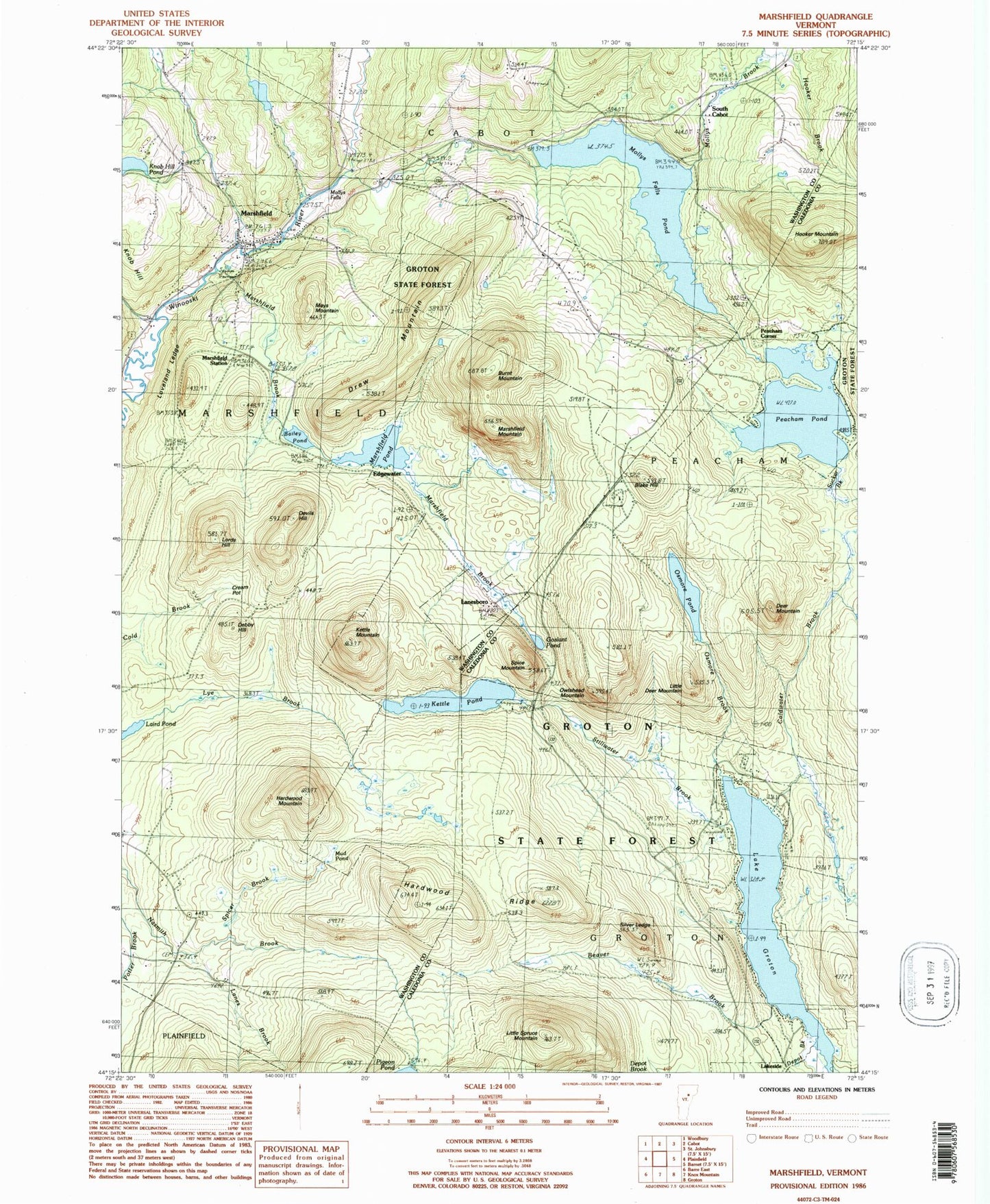
Classic USGS Marshfield Vermont 7.5'x7.5' Topo Map
Couldn't load pickup availability
Historical USGS topographic quad map of Marshfield in the state of Vermont. Typical map scale is 1:24,000, but may vary for certain years, if available. Print size: 24" x 27"
This quadrangle is in the following counties: Caledonia, Washington.
The map contains contour lines, roads, rivers, towns, and lakes. Printed on high-quality waterproof paper with UV fade-resistant inks, and shipped rolled.
Contains the following named places: Bailey Pond, Beaver Brook, Beaver Pond, Blake Hill, Burnt Mountain, Coldwater Brook, Cream Pot Meadow, Debby Hill, Deer Mountain, Depot Brook, Devils Hill, Drew Mountain, Edgewater, Goslant Pond, Groton State Forest, Lake Groton, Hardwood Mountain, Hardwood Ridge, Kidder Brook, Hooker Mountain, Osmore Brook, Kettle Mountain, Kettle Pond, Knob Hill Pond, Laird Pond, Lanes Brook, Lanesboro, Little Deer Mountain, Little Spruce Mountain, Lords Hill, Loveland Ledge, Marshfield, Marshfield Brook, Marshfield Mountain, Turtlehead Pond, Marshfield Station, Mays Mountain, Mollys Brook, Mollys Falls, Mud Pond, New Discovery Cemetery, Osmore Pond, Owlshead Mountain, Peacham Pond, Silver Ledge, South Cabot, Spice Mountain, Spicer Brook, Stillwater Brook, Sucker Brook, Lakeside, Peacham Corner, Town of Marshfield, Marshfield Number 6 Dam, Mollys Falls Pond, Peacham Pond Dam, Groton Pond Dam, Bailey Pond Dam, Richards Dam, Laird Pond Dam, Christ Covenant Ministries, Federated Church, Hudson Cemetery, Jaquith Public Library, Maple Hill-Bolles Cemetery, Marshfield Municipal Forest, Marshfield Post Office, South Cabot Cemetery, Thistle Hill Camping Area, Wooster Cemetery, Big Deer Campground, Big Deer Mountain Trail, Big Deer Recreation Area, Boulder Beach, Boulder Beach Recreation Area, Coldwater Brook Trail, Groton Nature Center, Groton State Forest Nature Trail, Hosmer Brook Trail, Kettle Pond Group Camping Area, Kettle Pond Trail, Little Deer Trail, New Discovery Campground, New Discovery Recreation Area, Osmore Pond Hiking Loop, Osmore Pond Picnic Shelter, Owls Head Trail, Silver Ledge Trail, Stillwater Campground, Stillwater Recreation Area, Marshfield Fire Department, Village of Marshfield