MyTopo
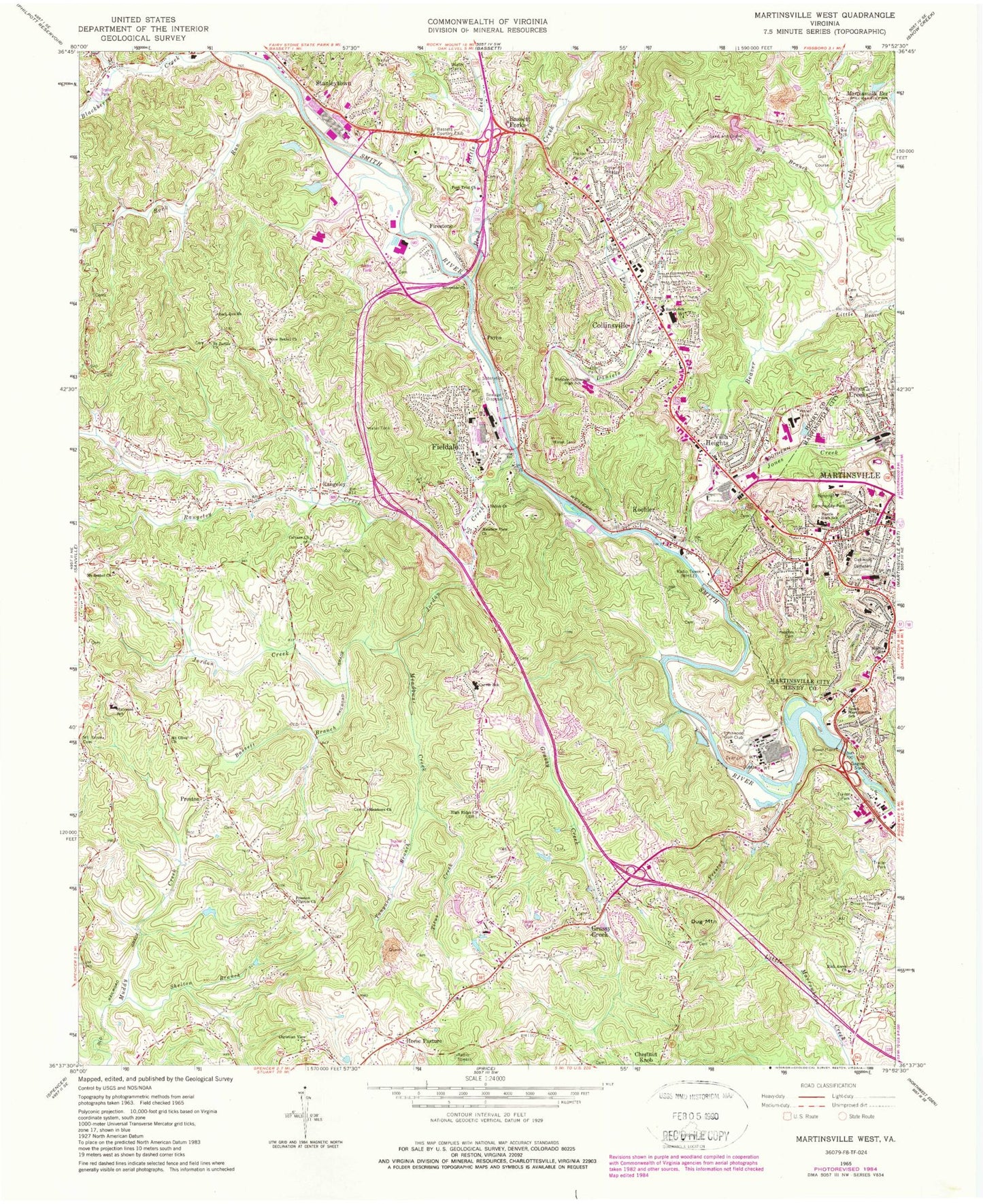
Classic USGS Martinsville West Virginia 7.5'x7.5' Topo Map
Couldn't load pickup availability
Historical USGS topographic quad map of Martinsville West in the state of Virginia. Map scale may vary for some years, but is generally around 1:24,000. Print size is approximately 24" x 27"
This quadrangle is in the following counties: Henry, Martinsville (city).
The map contains contour lines, roads, rivers, towns, and lakes. Printed on high-quality waterproof paper with UV fade-resistant inks, and shipped rolled.
Contains the following named places: Albert Harris Elementary School, American National University - Martinsville Campus, Apostle Faith Church, Bassett Branch, Bassett Country Club, Bassett Forks, Bassett High School, Bassett Rescue Squad, Beaver Creek, Big Branch, Brown School, Calvary Church, Carver Elementary School, Christian View Church, Church of God, Collinsville, Collinsville Census Designated Place, Collinsville District, Collinsville Post Office, Collinsville Primary School, Collinsville Volunteer Fire Department, Daniels Creek, Dug Mountain, Fayette Street Christian Church, Fieldale, Fieldale - Collinsville Volunteer Rescue Squad, Fieldale Baptist Church, Fieldale Census Designated Place, Fieldale Collinsville Middle School, Fieldale Elementary School, Fieldale Post Office, Fieldale Quarry, Fieldale Volunteer Fire Department, Firestone, Fort Trial Church, Grace United Presbyterian Church, Grassy Creek, Grassy Creek School, Hairston School, Hall School, Harris High School, Henry County, Henry County Farm, Henry County Jail, Henry County Sheriff's Office, Heusley, High Ridge Church, High Street Baptist Church, Hill Memorial Baptist Church, Horse Pasture, Horse Pasture Census Designated Place, Horsepasture District, Horsepasture District Volunteer Fire Department, John Redd Smith Elementary School, Jones Creek, Jordan Creek, Koehler, Liberty Fair Mall, Little Beaver Creek, Little Reed Creek, Lynnwood Golf Club, Martin School, Martinsville City Hall, Martinsville City Sheriff's Office, Martinsville Fire and Emergency Medical Services Station 1, Martinsville Military Academy, Martinsville Post Office South End Station, Meadow View Church, Meadows Church, Meadows Creek, Meadows School, Mount Bethel Church, Mount Carmel Pentecostal Holiness Church, Mount Olive Cemetery, Mount Olive Church, Mount Zion Holiness Apostolic Church, Mount Zion Holiness Church, New Bethel Church, New College Institute, North Martinsville Pentecostal Holiness Church, Oakwood Cemetery, Patriot Centre Fire and Emergency Medical Services, Payne, Peoples Cemetery, Piedmont Governor's School for Mathematics Science and Technology, Pilgrim Baptist Church, Preston, Preston Branch, Preston Pilgrim Church, Rangeley, Rangeley Creek, Reed Creek, Rich Acres Church, Ridgeway Fire Department Station 2, Riverside Church, Rock Run, Rock Run Church, Rough and Ready Mill, Saint James Church, Saint Pauls Church, Shelton Branch, Shiloh Church, Shumate School, Smith River Dam, South Martinsville School, Stanleytown, Stanleytown Baptist Academy, Stanleytown Elementary School, Stanleytown Post Office, Stanleytown United Methodist Church, Stultz School, Tanyard Branch, Teresas School of Dance, Titus Creek, Trinity Friends Church, Villa Heights, Villa Heights Baptist Church, Villa Heights Census Designated Place, WCBX-AM (Fieldale), WFIC-AM (Collinsville), WHEE-AM (Martinsville), ZIP Codes: 24078, 24089, 24168