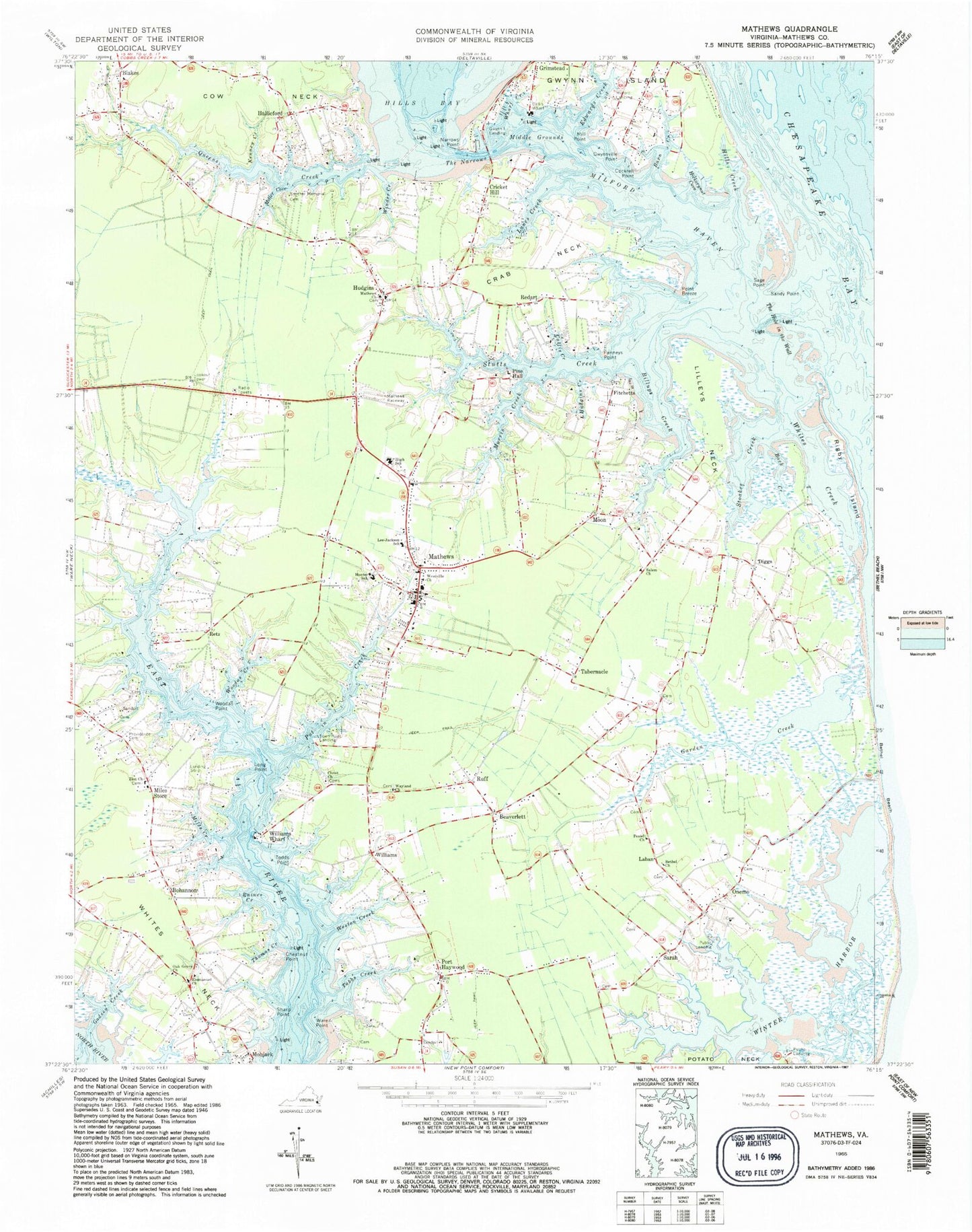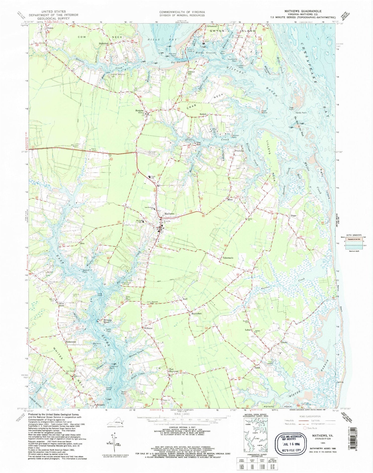
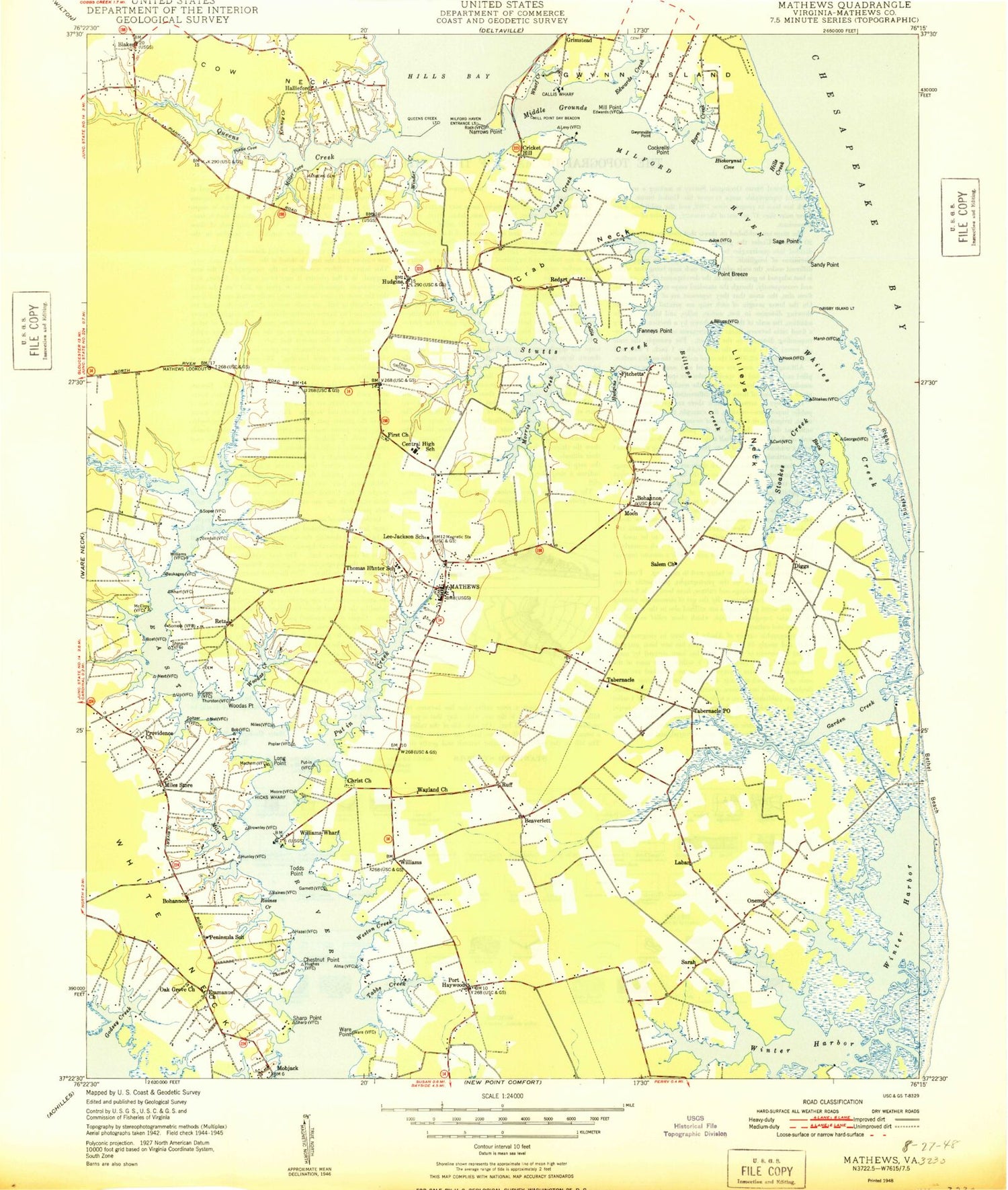
MyTopo
Classic USGS Mathews Virginia 7.5'x7.5' Topo Map
Couldn't load pickup availability
Historical USGS topographic quad map of Mathews in the state of Virginia. Typical map scale is 1:24,000, but may vary for certain years, if available. Print size: 24" x 27"
This quadrangle is in the following counties: Mathews.
The map contains contour lines, roads, rivers, towns, and lakes. Printed on high-quality waterproof paper with UV fade-resistant inks, and shipped rolled.
Contains the following named places: Back Creek, Barn Creek, Beaverlett, Bethel Church, Billups Creek, Callis Creek, Callis Wharf, Chestnut Point, Christ Church, Cockrell Point, Cow Neck, Crab Neck, Edwards Creek, Emmanuel Church, Fanneys Point, Garden Creek, Godsey Creek, Gwynville Point, Hickorynut Cove, Hills Bay, Hills Creek, Hudgins, Hudgins Creek, Thomas Hunter Middle School, Kenney Creek, Lanes Creek, Lee - Jackson Elementary School, Lilleys Neck, Long Point, Mathews Church, Middle Grounds, Miles Creek, Miles Store, Milford Haven, Mill Point, Miller Cove, Moon, Morris Creek, Narrows Point, Oak Grove Church, Peniel Church, Pine Hall, Point Breeze, Port Haywood, Providence Cemetery, Put in Creek, Raines Creek, Rigby Island, Ruff, Sage Point, Salem Church, Sandy Point, Blakes, Zion Church, Sharp Point, Smither Memorial Cemetery, Stoakes Creek, Tabbs Creek, Tabernacle, The Hole in the Wall, The Narrows, Thomas Creek, Todds Point, Ware Point, Wayland Church, Weston Creek, Westville Church, Wharf Creek, Whites Neck, Williams Wharf, Winder Creek, Winter Harbor, Woodas Creek, Woodas Point, Diggs, Hallieford, Onemo, Sarah, Williams, Hicks Wharf, Haven Beach, Postle Cove, Mathews County, Mathews Raceway, Bohannon, Cricket Hill, Fitchetts, Gwynn Island Landing, Laban, Milford Landing, Redart, Retz, Town Point Landing, Mobjack, Mathews, Whites Creek, Beaverdam School (historical), Bowen - Sadler Cemetery, Cedar Lane Landing, Cattail School (historical), Christ Church Cemetery, Deal Cemetery, First Baptist Church, First Baptist Church Cemetery, Fitchett Wharf Landing, Foster Cemetery, Gosehn Cemetery, Hamburg School (historical), Hamburg School Cemetery, Haven (historical), Hudgins Cemetery, Hudgins Cemetery, Hudgins Cemetery, Hudgins Cemetery, Hurst - Ward Burial Ground, John Forrest Grave, Knight Burial Ground, Knight Cemetery, Lawrenceville School (historical), Marchant Cemetery, Mathews Cemetery, Mathews County Courthouse, Mathews High School, Methodist Tabernacle, Mickelborough Cemetery, Morgan Cemetery, Owens Cemetery, Owens - Parker Cemetery, Perkins Springs Cemetery, Poplar Grove Cemetery, Powell Cemetery, Queens Creek Landing, Ruff Cemetery, School B (historical), Stuart Cemetery, Wharf Lane School (historical), Westville School (historical), White Cemetery, Williams Cemetery, Williams Wharf Landing, Winter Harbor Haven, Winter Harbor Landing, Piankatank District, Westville District, Mathews County Sheriff's Office, Mathews Volunteer Fire Department Station 1, Mathews Volunteer Rescue Squad, Mathews Volunteer Rescue Squad, Mathews Volunteer Fire Department Station 2, Mathews County Sheriff's Office, Grimstead Landing Boat Ramp, Milford Landing Boat Ramp, Roses Creek Landing Boat Ramp, Town Point Landing Boat Ramp, Whites Creek Landing Boat Ramp, Winter Harbor Haven Boat Ramp, Winter Harbor Landing Boat Ramp, Narrows Marina, Winter Harbor Haven Marina, Mathews Memorial Library, Riverside Convalescent Center at Mathews, Perrin Boat Yard, Mathews County Senior Center, Mathews County Youth Center, Mathews County Government Center, Gwynn Census Designated Place, Mathews Census Designated Place, Hudgins Post Office, Hallieford Post Office, Mathews Post Office, Moon Post Office, Onemo Post Office, Port Haywood Post Office, Foster Field