MyTopo
Classic USGS Maysville Alabama 7.5'x7.5' Topo Map
Couldn't load pickup availability
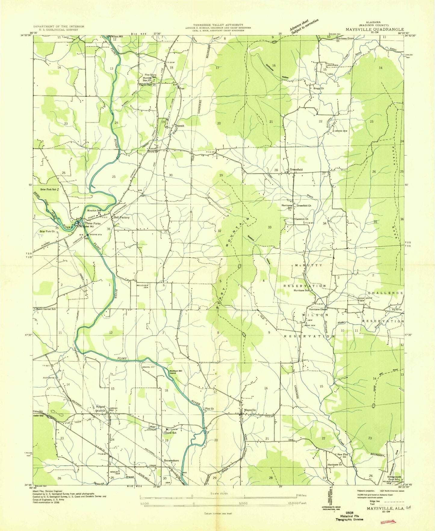
Historical USGS topographic quad map of Maysville in the state of Alabama. Typical map scale is 1:24,000, but may vary for certain years, if available. Print size: 24" x 27"
This quadrangle is in the following counties: Madison.
The map contains contour lines, roads, rivers, towns, and lakes. Printed on high-quality waterproof paper with UV fade-resistant inks, and shipped rolled.
Contains the following named places: Acuff Spring, Baker Cemetery, Bales Spring, Barley Branch, Barley Cove, Bell Factory, Belleview Cemetery, Berry Hollow, Berry Mountain, Berry Spring, Bone Cemetery, Bone Cemetery, Bragg Cemetery, Branon Hollow, Brier Fork Church, Brier Fork Flint River, Buckhorn Branch, Burdine Branch, Burns Spring, Cedar Gap, Cedar Grove Church, Central Junior High School, Challenge Reservation (historical), Chase Creek, Connally Cemetery, Crowson Hill Cemetery, Elder Branch, Flint Church, Hewlett Cemetery, Hurricane School, Jasper Point, Jordan Cemetery, Lewis Mountain, Lollar Branch, McNutty Reservation, Molder Branch, Moore Spring, Morning Star Church, Mount Carmel, Murphy Spring, Nance Mountain, Nelson Chapel Cemetery, Pine Grove Cemetery, Possum Hollow, Potato Knob, Reddick Hollow, Riverton Junior High School, Ryland, Saint Clair Cemetery, Sharp Cove, Shiloh Church, Sisco Cemetery, Spriggs Cemetery, Stiles Chapel, Stillhouse Hollow, Stone Hollow, Wortham Mill Island, Madison County Public Lake Dam, Blackburn Cemetery, Blackwell (historical), Brier Fork School (historical), Buckhorn High School, Fellowship Church, Greenfield Church, Huntsville Equitation School, Hurricane School (historical), Jones Memorial Church, Killingsworth School (historical), Madison County Lake, Molder (historical), Mount Carmel School (historical), Patton Cemetery, Saint Paul Church (historical), Stone Cemetery, Bragg Cemetery, Cameron Methodist Church, McCrary Cemetery, Union Cemetery, Hurricane Chapel, Hurricane Church, Hurricane Grove Church, Locust Grove Baptist Church, Maysville, Mountain Fork, Pilgrim Rest Church, Saint Clair Store, Wear Chapel, Buckhorn, Deposit, Greenfield, McCaleb Mill, Three Forks, Burdine Cemetery, Drake - Keith Cemetery, Locust Grove Cemetery, Ryland Cemetery, New Market Division, Maysville Post Office, Ragsdale Cemetery, Millers Mill (historical), New Flint Church (historical), Pine Grove School (historical), Acklin - Derrick Cemetery, Tally Cemetery, Clopton Cemetery, Jehu Lawler Cemetery, Chambless - Byrne Cemetery, Daniel - Lawler Cemetery, Rogers Cemetery, Harbin - Dalton Cemetery, Roundtree-Gentry Cemetery, Steger - Ormond Cemetery, Kelly Cemetery, Morrow - Stewart Cemetery, Russell J Kelly Cemetery, Norris Cemetery, Massengale Cemetery, Flint Ridge Farm, Central Volunteer Fire Department Station 3, Central Volunteer Fire Department Station 1, Central Volunteer Fire Department Station 2, Rigney Cemetery, Ryland Post Office, Acuff Spring, Baker Cemetery, Bales Spring, Barley Branch, Barley Cove, Bell Factory, Belleview Cemetery, Berry Hollow, Berry Mountain, Berry Spring, Bone Cemetery, Bone Cemetery, Bragg Cemetery, Branon Hollow, Brier Fork Church, Brier Fork Flint River, Buckhorn Branch, Burdine Branch, Burns Spring, Cedar Gap, Cedar Grove Church, Central Junior High School, Challenge Reservation (historical), Chase Creek, Connally Cemetery, Crowson Hill Cemetery, Elder Branch, Flint Church, Hewlett Cemetery, Hurricane School, Jasper Point, Jordan Cemetery, Lewis Mountain, Lollar Branch, McNutty Reservation, Molder Branch, Moore Spring, Morning Star Church, Mount Carmel, Murphy Spring, Nance Mountain, Nelson Chapel Cemetery, Pine Grove Cemetery, Possum Hollow, Potato Knob, Reddick Hollow, Riverton Junior High School, Ryland, Saint Clair Cemetery, Sharp Cove, Shiloh Church, Sisco Cemetery, Spriggs Cemetery, Stiles Chapel, Stillhouse Hollow, Stone Hollow, Wortham Mill Island, Madison County Public Lake Dam, Blackburn Cemetery, Blackwell (historical), Brier Fork School (historical), Buckhorn High School, Fellowship Church, Greenfield Church, Huntsville Equitation School, Hurricane School (historical), Jones Memorial Church, Killingsworth School (historical), Madison County Lake, Molder (historical), Mount Carmel School (historical), Patton Cemetery, Saint Paul Church (historical), Stone Cemetery, Bragg Cemetery, Cameron Methodist Church, McCrary Cemetery, Union Cemetery, Hurricane Chapel, Hurricane Church, Hurricane Grove Church, Locust Grove Baptist Church, Maysville, Mountain Fork, Pilgrim Rest Church, Saint Clair Store, Wear Chapel, Buckhorn, Deposit, Greenfield, McCaleb Mill, Three Forks, Burdine Cemetery, Drake - Keith Cemetery, Locust Grove Cemetery, Ryland Cemetery, New Market Division, Maysville Post Office, Ragsdale Cemetery, Millers Mill (historical), New Flint Church (historical), Pine Grove School (historical), Acklin - Derrick Cemetery, Tally Cemetery, Clopton Cemetery, Jehu Lawler Cemetery, Chambless - Byrne Cemetery, Daniel - Lawler Cemetery, Rogers Cemetery, Harbin - Dalton Cemetery, Roundtree-Gentry Cemetery, Steger - Ormond Cemetery, Kelly Cemetery