MyTopo
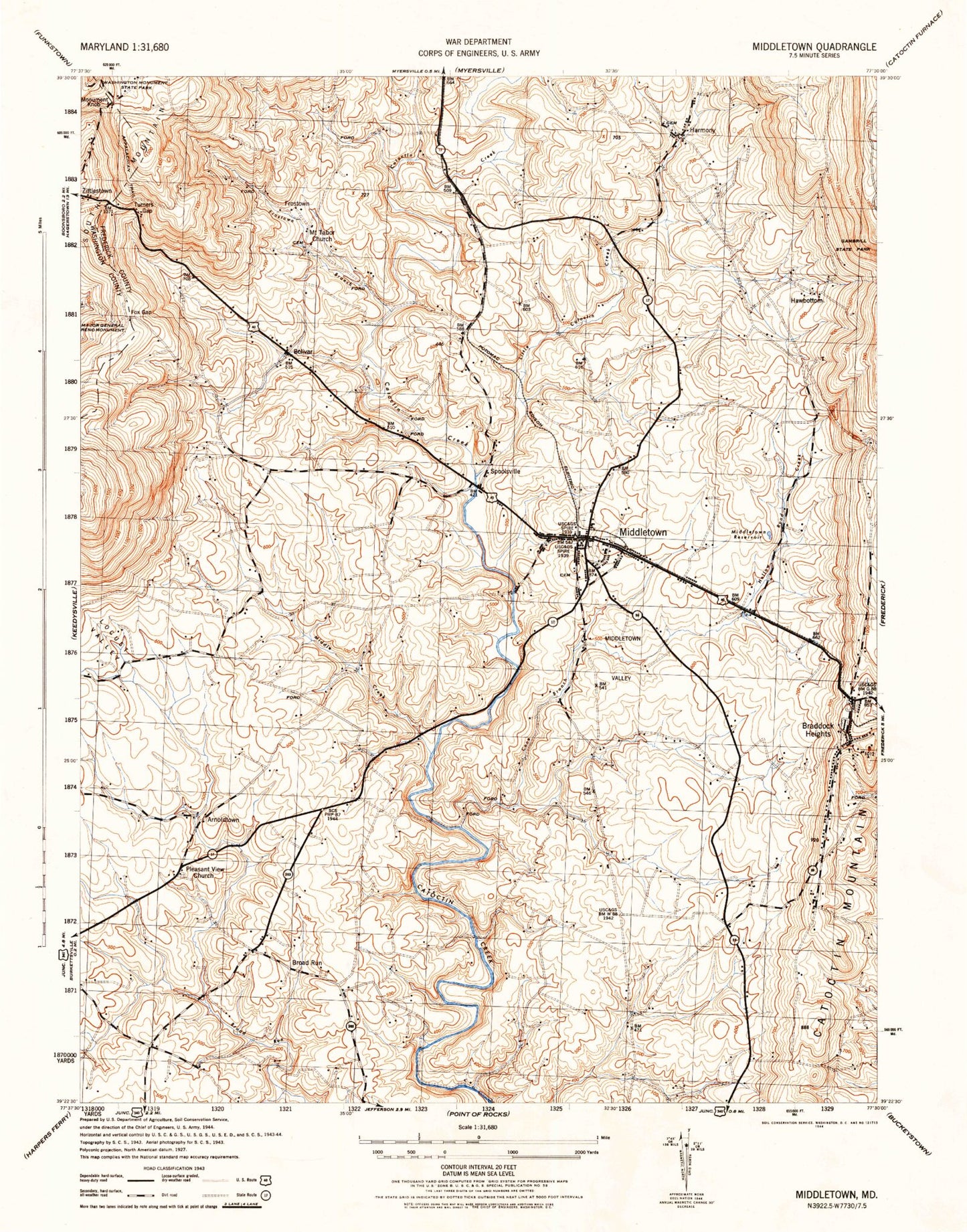
Classic USGS Middletown Maryland 7.5'x7.5' Topo Map
Couldn't load pickup availability
Historical USGS topographic quad map of Middletown in the state of Maryland. Typical map scale is 1:24,000, but may vary for certain years, if available. Print size: 24" x 27"
This quadrangle is in the following counties: Frederick, Washington.
The map contains contour lines, roads, rivers, towns, and lakes. Printed on high-quality waterproof paper with UV fade-resistant inks, and shipped rolled.
Contains the following named places: Bolivar, Cone Branch, Frostown Branch, Grindstone Run, Hollow Road Creek, Little Catoctin Creek, Locust Valley, Middle Creek, Middletown, Middletown Reservoir, Middletown Valley, Pleasant View Church, Reno Monument, Turners Gap, Spoolsville, Fox Gap, Arnoldtown, Braddock Heights, Broad Run, Frostown, Harmony, Hawbottom, Zittlestown, WJTM-FM (Frederick), WARX-FM (Hagerstown), WAFY-FM (Middletown), Samuels Run, Arch Bridge, Beachley, Bellemonte, Bennies Hill Road Bridge, Bidle Hill Acres, Bidle Industrial Park, Bolivar Branch, Bolivar Heights, Braddock Estates, Braddock Heights Post Office, Brandenburg Estates, Broad Run Acres, Brookridge North, Burkitts Run, Catoctin Acres, Catoctin Hills, Christ Reformed Church, Church of Saint Joseph of the Sacred Heart of Jesus, Coblentz Heights, Colebrook, Corner House, Countryside West, Cowell, Crest Manor Estates, Cross Hollow, Der Spring Farms, Deer Springs Branch, Edinburg Forest, Elm Springs Farm, Everhart School (historical), Fink School (historical), Fountain Dale, Fountaindale South, Foxfield Middletown, Gambrill South, Glenoble, Glenridge Estates, Harmony Brethren Cemetery, Harmony Brethren Church, Harmony Cemetery, Harmony Knolls, Harshman Estates, Hawbottom Branch, Hawbottom Heights, Hollow Estates, Hollow Road Estates, Holter, Homers Delight, Horman, Johnson Cemetery, Kelview, Koogles School (historical), Lambs Knoll Farm, Lockwood Heights, Manor Run, Middletown Cemetery, Middletown Elementary School, Middletown Heights, Middletown High School, Middletown Library, Middletown Manor, Middletown Middle School, Middletown Park, Middletown Post Office, Middletown Recreational Park, Middletown South, Middletown Valley Estates, Middletown View, Minnick, Morningside, Moser, Mount Tabor Cemetery, Mount Tabor Church (historical), North Jefferson, Oak Park, Picnic Woods Estates, Pleasant View Church of the Brethren Cemetery, Poffenberger Road Bridge, Quebec School (historical), Remsberg Acres, Reno School (historical), Shadows of the Old South, Skyline Estates, Skyline Gardens, Somerset, Springdale, Station Roads, Strawleigh, Summers, Sunset View, Town Center Plaza Shopping Center, Tyler School (historical), Valley Heights, Valley Overlook, Valley View Estates, Waynes Way, West Middletown Estates, Westchester, Wiles Branch, Wiles Estates, Wilmar Farms, Woodcrest, Zion Lutheran Cemetery, Zion Lutheran Church, Ridge Crest Estates, District 22 Burkittsville, District 3 Middletown, Middletown Branch Library, Capitol Heights Vokunteer Fire Department, Middletown Volunteer Fire Company Station 7, Braddock Heights Volunteer Fire Company Station 12, Frederick MontessoriFrederick Montessori School, Middletown United Methodist Chuch Preschool, Middletown Primary School, Town of Middletown, Deerspring Dairy Farm, Distillery Lane Ciderworks, Middletown Farm