MyTopo
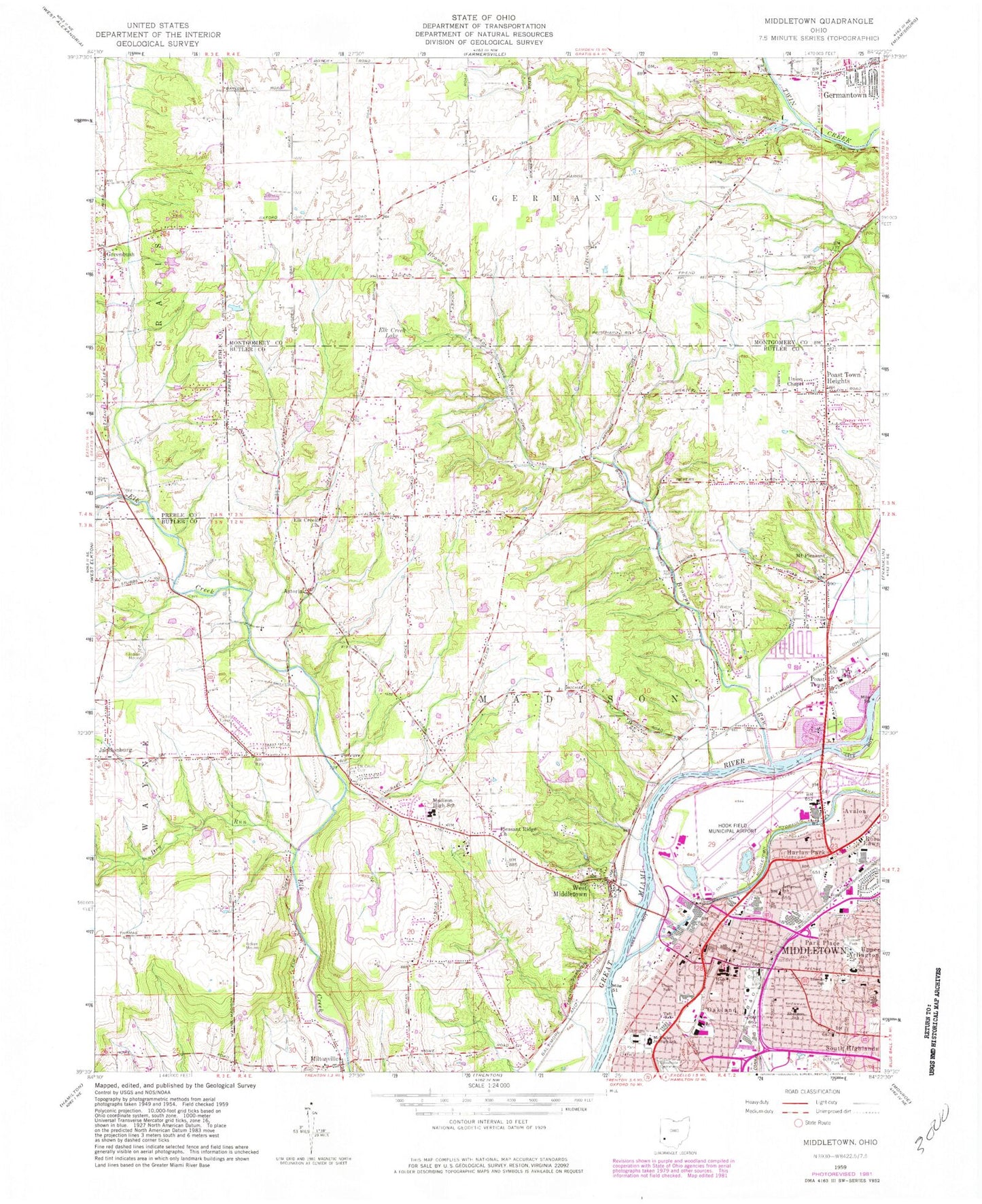
Classic USGS Middletown Ohio 7.5'x7.5' Topo Map
Couldn't load pickup availability
Historical USGS topographic quad map of Middletown in the state of Ohio. Typical map scale is 1:24,000, but may vary for certain years, if available. Print size: 24" x 27"
This quadrangle is in the following counties: Butler, Montgomery, Preble.
The map contains contour lines, roads, rivers, towns, and lakes. Printed on high-quality waterproof paper with UV fade-resistant inks, and shipped rolled.
Contains the following named places: Astoria Cemetery, Browns Run, Dry Run, Elk Creek Cemetery, Elk Creek Lake, Gardner Park, Goldman Park, Lincoln School, Madison High School, Middletown Hydraulic Canal, Sherman School, Smith Park, Sunset Park, Union School, Madison Middle School, West Middle School, Forest Hills Country Club, McKinley Elementary School (historical), Old South Park, Doty Park, Oakland Park, John XXIII School, Saint Johns Catholic Church, Stephen Vail Middle School, Middletown Public Library, First United Methodist Church, Temple of God, Saint Pauls United Church of Christ, Bethlehem Lutheran Church, Ratham Park, Holy Trinity Catholic Church, Flemming Park, Middletown Cemetery, Gladell Park, Middletown Regional Hospital, First Presbyterian Church, Eleventh Street Church of God, Barnitz Park, Second Baptist Church, Weatherwax Golf Course, Sebald Park, Church of the Ascension, Saints Constantine and Helen Greek Orthodox Church, Faith United Methodist Church, Astoria, Avalon, Harlan Park, Miltonville, Rose Lawn, South Highlands, Mudlick Mill, Poast Town Heights, Elk Creek Church, Miltonville Cemetery, Pleasant Ridge United Methodist Church, Union Chapel United Methodist Church, Middletown, Poast Town, West Middletown, Kercher Park, Greenbush, Oakland, Mudlick, Bethlehem Temple Apostolic Church, Church of Christ, First Christian Church, Harlan Park First Church of God, South Main Street Historic District, School Number 7 (historical), School Number 10 (historical), School Number 3 (historical), School Number 5 (historical), School Number 7 (historical), School Number 11 (historical), School Number 2 (historical), School Number 1 (historical), School Number 6 (historical), Poasttown Elementary School, Mount Pleasant Church, School Number 13 (historical), School Number 1 (historical), Oakland Presbyterian Church (historical), Saint Pauls German Lutheran Church (historical), Calvary Cemetery, Trinity School, Miami Park, Browns Chapel, Upper Arlington, Black Lake Dam, Black Pond, Middletown Sportsmen Club Dam, Middletown Sportsmen Club Lake, Will-O-Bob Lake Dam, Will-O-Bob Lake, Guffey Lake Dam, Guffey Lake, Jefferson Elementary School (historical), Roosevelt Elementary School, Taft Elementary School, Middletown Post Office, Jims Airport, Middletown Regional Airport/Hook Field, Middletown Hospital Heliport, Township of Madison, Township of German, Holly Oaks Farm, Jacksonburg Cemetery, Mount Pleasant Cemetery, Old Jacksonburg Cemetery, Brown Run Cemetery, Poast Town Post Office (historical), Miltonville Post Office (historical), Astoria Post Office (historical), West Middletown Post Office (historical), Greenbush Post Office (historical), Middletown Fire Station 81, Middletown Division of Fire Station 4, Browns Run Country Club, Catalina Mobile Home Park, Avalon Park, Barnitz Stadium, Bicentennial Commons, Crawford Park, Sherman Park, University Park, Middletown Water Treatment Plant, Farpoint Airfield, Rosa Parks Elementary School, Madison Township Fire Department Station 152, Middletown Division of Fire Station 3 Headquarters, Madison Township Fire Department South Headquarters, Madison Township Life Squad, German Township Police Department, Middletown Police Department, Madison Township Fire Department Station 153