MyTopo
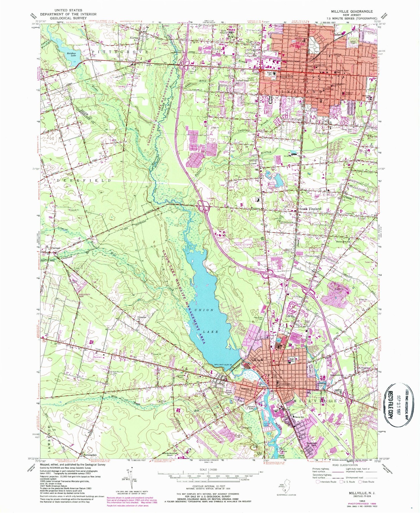
Classic USGS Millville New Jersey 7.5'x7.5' Topo Map
Couldn't load pickup availability
Historical USGS topographic quad map of Millville in the state of New Jersey. Map scale may vary for some years, but is generally around 1:24,000. Print size is approximately 24" x 27"
This quadrangle is in the following counties: Cumberland, Salem.
The map contains contour lines, roads, rivers, towns, and lakes. Printed on high-quality waterproof paper with UV fade-resistant inks, and shipped rolled.
Contains the following named places: Bacon School, Butler Avenue School, Carmel, CARMEL HEBREW CEMETERY, Central School, Chatfield Branch, Child Family Center Preschool, City of Millville, Clayville, Creative Achievement Academy Grape Street School, Creative Achievement Academy West Avenue School, Creative Achievement Academy Wood Street Elementary School, Culver School, Cumberland Christian School, Cumberland County College, Cunningham School, Delsea Drive-In, Doctor Mennies School, Dr William Mennies Elementary School, Early Learning Center, Farmingdale, Greenwood Cemetery, Hankins Pond, Hankins Pond Dam, Holy Cross Cemetery, John H Winslow Elementary School, Kidston Towers, Lakeside Middle School, Landis Junior High School, Landis Park, Lebanon Branch, Little Robin Branch, Lummis Marsh Branch, Maurice Fels Elementary School, Max Leuchter Elementary School, Memorial High School, Memorial Junior High School, Mill Creek, Millville, Millville Fire Department, Millville Police Department, Millville Post Office, Millville Rescue Squad, Millville Senior High School, Mount Pleasant Cemetery, Mount Pleasant Elementary School, Muddy Run, Necombtown, New Life Academy School, Newcomb Hospital, Newcombtown Church, Norma, Norma Alliance Volunteer Fire and Rescue, Norma Post Office, Norma Station, Oak Hill Cemetery, Orchard Road School, Parvin Branch, Pineland Learning Center Middle School, Rainbow Lake, Rainbow Lake Dam, Rehabilitation Hospital of South Jersey, Rieck Avenue Elementary School, Roosevelt Park, Sacred Heart Cemetery, Sacred Heart High School, Sacred Heart School, Saint Francis of Assisi School, Saint Mary Magdalen Elementary School, Saint Nicholas Church, Saint Peter-Paul Church, Siloam Cemetery, Silver Lake, Silver Run Elementary School, South Vineland, South Vineland Elementary School, South Vineland Post Office, Tarkiln Branch, Thomas W Wallace Junior Middle School, Ukranian Church, Union Lake, Union Lake Dam, Veterans Memorial Home Cemetery, Vineland, Vineland Adult Education Center, Vineland Alternative High School, Vineland Circle, Vineland Emergency Medical Services Station 1, Vineland Emergency Medical Services Station 2, Vineland Emergency Medical Services Station 3, Vineland Fire Department - Fire Chief, Vineland Fire Department Station 1, Vineland Fire Department Station 2, Vineland Fire Department Station Number 6, Vineland Inspira Medical Center, Vineland Police Department, Vineland Post Office, Vineland Veterans Home Heliport, Vocational Tech Airstrip, WBSS-FM (Millville), Western School, WFHM-AM (Vineland), White Marsh Run, Wood School, WREY-AM (Millville), WVLT-FM (Vineland), ZIP Codes: 08332, 08360