MyTopo
Classic USGS Mindego Hill California 7.5'x7.5' Topo Map
Couldn't load pickup availability
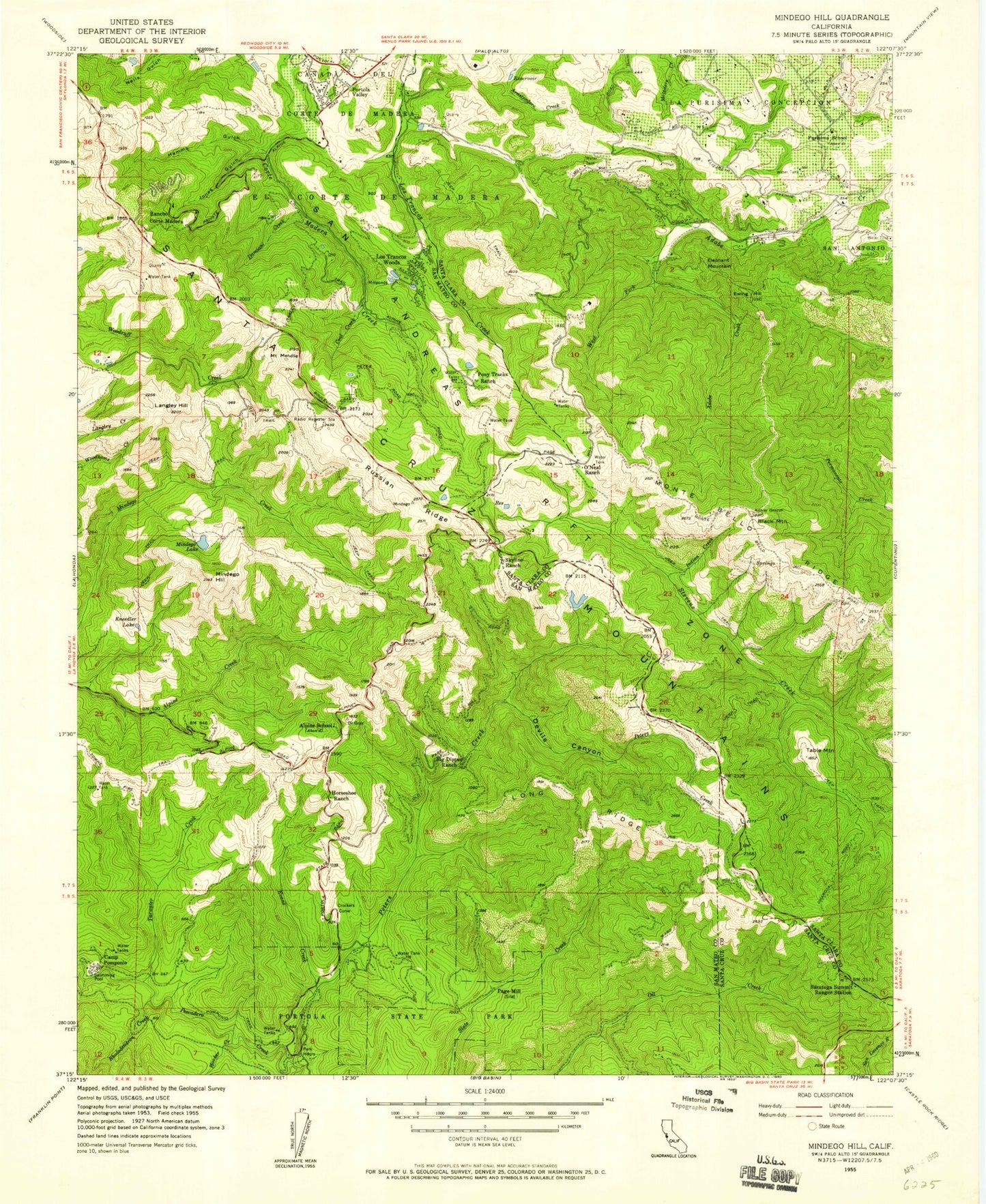
Historical USGS topographic quad map of Mindego Hill in the state of California. Typical map scale is 1:24,000, but may vary for certain years, if available. Print size: 24" x 27"
This quadrangle is in the following counties: San Mateo, Santa Clara, Santa Cruz.
The map contains contour lines, roads, rivers, towns, and lakes. Printed on high-quality waterproof paper with UV fade-resistant inks, and shipped rolled.
Contains the following named places: Bay Creek, Bear Creek, Big Dipper Ranch, Borel Hill, Bozzo Gulch, Camp Pomponio, Coal Creek, Coal Mine Ridge, Corte Madera Elementary School, Coyote Ridge Trail, Crockers Curve, Damiani Creek, Devils Canyon, Doherty Ridge, Evans Creek, Ewing Hill, Foothill College, Foothills Park, Gold Mine Creek, Hamms Gulch, Horseshoe Ranch, Indian Cabin Creek, Indian Creek, Jones Gulch, Knuedler Lake, Lambert Creek, Long Ridge, Mount Melville, Mindego Hill, Mindego Lake, Monte Bello Ridge, Mount Helen Childrens Home, Page Mill, Peters Creek, Pomponio Trail, Pony Tracks Ranch, Portola Redwoods State Park, Purissima School, Rancho Corte Madera, Rengstorff Gulch, Rhododendron Creek, Rodgers Gulch, Russian Ridge, Saratoga Summit Ranger Station, Shotgun Bend, Skyline Ranch, Summit Trail, Table Mountain, Tarwater Creek, Trappers Trail, West Fork Adobe Creek, El Corte de Madera, Spring Ridge, La Purisima Concepcion, Windy Hill, Palo Alto Hills Golf and Country Club, Black Mountain, Elephant Mountain, Kelly Hill, Langley Hill, Los Trancos Woods, Foothill Park 1036 Dam, Rickey 1603 Dam, KFJC-FM (Los Altos), Bear Creek Trail, Coal Creek Open Space, Frog Pond Park, Heritage Grove Redwood Preserve, Hillside Group Camp, Huckleberry Picnic Area, Madrone Picnic Area, Old Tree Trail, Peters Creek Loop Trail, Point Group Camp, Portola State Park Office and Visitors Center, Ravine Group Camp, Russian Ridge Open Space Preserve, San Mateo County Jail, Sequoia Nature Trail, Shingle Mill Creek, Skyline Ridge Open Space Preserve, Slate Creek Trail Camp, Tanoak Picnic Area, Tarwater Trail Camp, Tarwater Trail Loop, Upper Coyote Ridge Trail, Vista Verde, Windy Hill Open Space, Borondo Lake, Foothills Open Space Preserve, Foothills Park Nature Interpretive Center, Los Trancas Open Space Preserve, Monte Bello Open Space Preserve, Deep Gulch, Town of Portola Valley, Town of Los Altos Hills, Woodside Fire Protection District Station 8, Santa Clara County Fire Department El Monte Fire Station, New Page Mill Quarries (historical), Langley Hill Quarry, Moody Creek, Bay Creek, Bear Creek, Big Dipper Ranch, Borel Hill, Bozzo Gulch, Camp Pomponio, Coal Creek, Coal Mine Ridge, Corte Madera Elementary School, Coyote Ridge Trail, Crockers Curve, Damiani Creek, Devils Canyon, Doherty Ridge, Evans Creek, Ewing Hill, Foothill College, Foothills Park, Gold Mine Creek, Hamms Gulch, Horseshoe Ranch, Indian Cabin Creek, Indian Creek, Jones Gulch, Knuedler Lake, Lambert Creek, Long Ridge, Mount Melville, Mindego Hill, Mindego Lake, Monte Bello Ridge, Mount Helen Childrens Home, Page Mill, Peters Creek, Pomponio Trail, Pony Tracks Ranch, Portola Redwoods State Park, Purissima School, Rancho Corte Madera, Rengstorff Gulch, Rhododendron Creek, Rodgers Gulch, Russian Ridge, Saratoga Summit Ranger Station, Shotgun Bend, Skyline Ranch, Summit Trail, Table Mountain, Tarwater Creek, Trappers Trail, West Fork Adobe Creek, El Corte de Madera, Spring Ridge, La Purisima Concepcion, Windy Hill, Palo Alto Hills Golf and Country Club, Black Mountain, Elephant Mountain, Kelly Hill, Langley Hill, Los Trancos Woods, Foothill Park 1036 Dam, Rickey 1603 Dam, KFJC-FM (Los Altos), Bear Creek Trail, Coal Creek Open Space, Frog Pond Park, Heritage Grove Redwood Preserve, Hillside Group Camp, Huckleberry Picnic Area, Madrone Picnic Area, Old Tree Trail, Peters Creek Loop Trail, Point Group Camp, Portola State Park Office and Visitors Center, Ravine Group Camp, Russian Ridge Open Space Preserve, San Mateo County Jail, Sequoia Nature Trail, Shingle Mill Creek, Skyline Ridge Open Space Preserve, Slate Creek Trail Camp, Tanoak Picnic Area, Tarwater Trail Camp, Tarwater Trail Loop, Upper Coyote Ridge Trail, Vista Verde, Windy Hill Open Space, Borondo Lake, Foothills Open Space Preserve, Foothills Park Nature Interpretive Center, Los Trancas Open Space Preserve, Monte Bello Open Space Preserve, Deep Gulch, Town of Portola Valley, Town of Los Altos Hills, Woodside Fire Protection District Station 8, Santa Clara County Fire Department El Monte Fire Station, New Page Mill Quarries (historical), Langley Hill Quarry, Moody Creek, Bay Creek, Bear Creek, Big Dipper Ranch, Borel Hill, Bozzo Gulch, Camp Pomponio, Coal Creek, Coal Mine Ridge, Corte Madera Elementary School, Coyote Ridge Trail, Crockers Curve, Damiani Creek, Devils Canyon, Doherty Ridge, Evans Creek, Ewing Hill, Foothill College, Foothills Park, Gold Mine Creek, Hamms Gulch, Horseshoe Ranch, Indian Cabin Creek, Indian Creek, Jones Gulch, Knuedler Lake, Lambert Creek, Long Ridge, Mount Melville, Mindego Hill, Mindego Lake, Monte Bello Ridge, Mount Helen Childrens Home, Page Mill, Peters Creek


