MyTopo
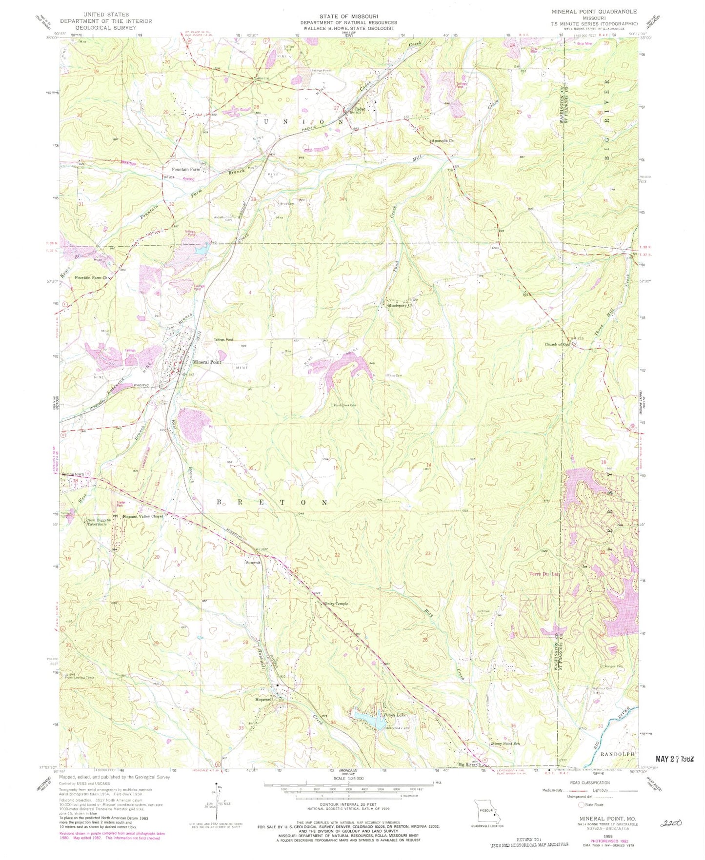
Classic USGS Mineral Point Missouri 7.5'x7.5' Topo Map
Couldn't load pickup availability
Historical USGS topographic quad map of Mineral Point in the state of Missouri. Map scale may vary for some years, but is generally around 1:24,000. Print size is approximately 24" x 27"
This quadrangle is in the following counties: St. Francois, Washington.
The map contains contour lines, roads, rivers, towns, and lakes. Printed on high-quality waterproof paper with UV fade-resistant inks, and shipped rolled.
Contains the following named places: Adelbert, Apex Lake, Apostolic Church of Jesus Christ, Aquilla Cole Cemetery, Big River Church, Black Tailings Dam, Boas Cemetery, Brick Cemetery, Cadet, Cadet Baptist Church, Cadet Mine Tailings Dam, Cadet Number 1 Dam, Cadet Post Office, Cadet School, Cadet Tailings Pond Number 2, Church of Jesus Christ, City of Potosi Waste Water Plant, City of Terre Du Lac Water Tower, Cornerstone Christian Academy, Dresser Industries Old Number 1 Dam, Dresser Minerals Number 7 Dam, Dresser Minerals Number 7 North Dam, Dresser Minerals Number 7 South Dam, Dresser Number 1 Dam, East Branch Mill Creek, Fountain Farm, Fountain Farm Branch, Fountain Farm School, French Town, Full Gospel Tabernacle, Happy Grove Church of God, Hopewell, Hopewell Assembly of God Church, Hopewell Church of God, Hopewell Community Center, Hopewell Union Church, Hornsey Brothers Tailings Pond, Huff Cemetery, Jarvis Farm Cemetery, Keyes Branch, Keyes Lead Diggings, Lac Bergerac, Lac Bergerac Dam, Lac Bourbon, Lac Bourbon Dam, Lac Capri, Lac Capri Dam, Lac Carmel, Lac Carmel Dam, Lac Catalina, Lac Catalina Dam, Lac Darcie, Lac Darcie Dam, Lac Michel, Lac Michel Dam, LeClerks Lead Diggings, Long Hollow, Mineral Point, Mineral Point Elementary School, Mineral Point Number 1 Dam, Mineral Point Number 2 Dam, Mineral Point Post Office, Mineral Point Town Hall, Negro Lead Diggings, New Diggens Tabernacle, Number 7 Washer Reservoir, Old Number 1 Reservoir, Old Washer Number 1 Dam, Old Wolf Dam, Pancake Lead Diggings, Pleasant Valley Chapel, Pond Creek, Pond Creek Baptist Church, Pond Creek Cemetery, Pond Creek School, Potosi Correctional Center, Potosi Fire Protection District House 3, Potosi Lake, Potosi Lake Dam, Potosi Lookout Tower, Rock Lead Diggings, Rubeneau Branch, Shibboleth Lead Mines, Stoney Point Missionary Baptist Church, Stony Point School, Summit, Terre du Lac, Terre Du Lac Fire Department Station 1, Town of Mineral Point, United Methodist Church, Unity Southern Baptist Church, Washington County Airport, West Branch Mill Creek, Westover Cemetery, White, White Cemetery, Yeargain Cemetery, ZIP Code: 63660