MyTopo
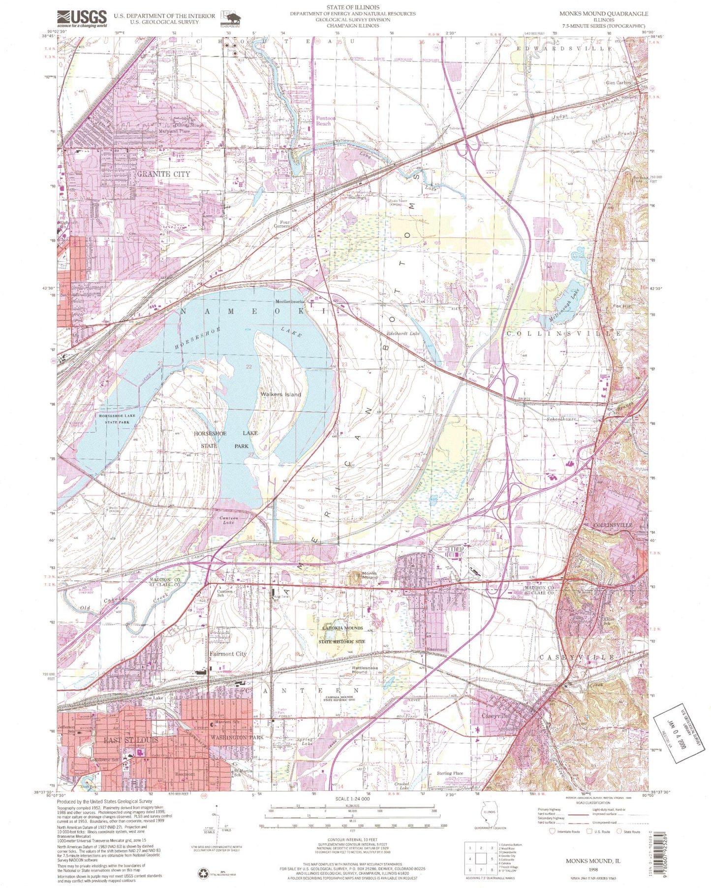
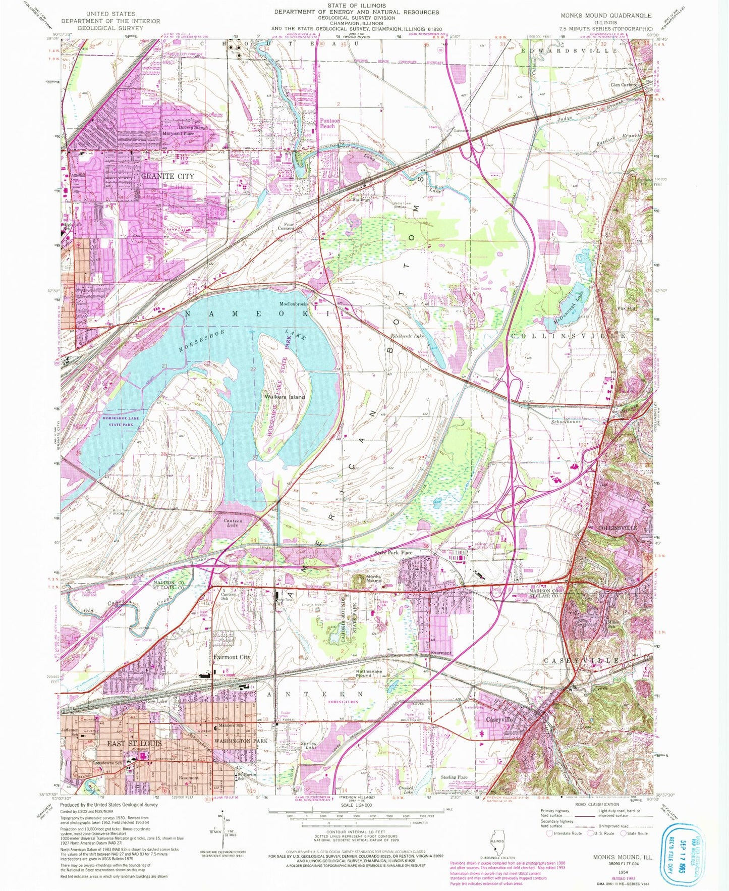
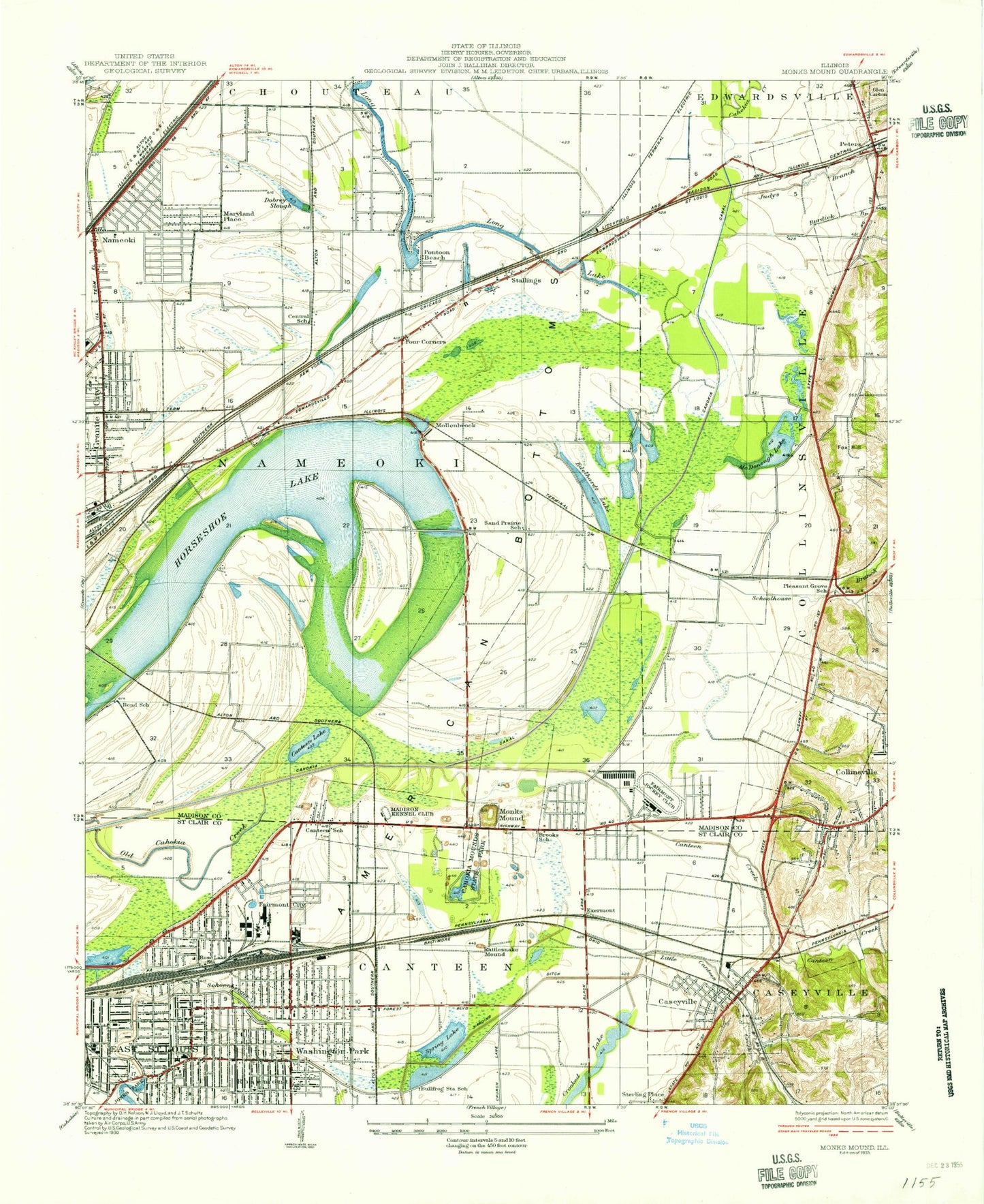
Classic USGS Monks Mound Illinois 7.5'x7.5' Topo Map
Couldn't load pickup availability
Historical USGS topographic quad map of Monks Mound in the state of Illinois. Map scale may vary for some years, but is generally around 1:24,000. Print size is approximately 24" x 27"
This quadrangle is in the following counties: Madison, St. Clair.
The map contains contour lines, roads, rivers, towns, and lakes. Printed on high-quality waterproof paper with UV fade-resistant inks, and shipped rolled.
Contains the following named places: Bellemore Village Shopping Center, Bend School, Brooks School, Bullfrog Station School, Burdick Branch, Cahokia Canal, Cahokia Creek, Cahokia Mounds State Historic SIte, Calvary Baptist Church, Canteen Creek, Canteen Lake, Canteen School, Caseyville, Caseyville Elementary School, Caseyville Police Department, Caseyville Post Office, Caseyville Volunteer Fire Department, Central Christian Church, Central School, City of Collinsville, City of East Saint Louis Engine House Number 2, City of Fairmont Village Hall, Collinsville High School, Collinsville Holiday Inn Heliport, Collinsville Post Office, Collinsville Wastewater Treatment Facility, Crooked Lake, Cross Roads Plaza Shopping Center, Dobrey Slough, Edelhardt Lake, Emmert Cemetery, Exermont, Fairmont City, Fairmont City Fire Department, Fairmont City Village Hall, Fairmount Jockey Club, Fairmount Park Race Track, Faith Baptist Church, Forest Chapel General Baptist Church, Four Corners, Fox Hill, Friendly Church of God, Frohardt Elementary School, Grace Methodist Church, Granite City Fire Department Station 3, Grigsby Middle School, Hawthorne Elementary School, Holy Angels Roman Catholic Church, Holy Angels School, Horseshoe Lake, Horseshoe Lake State Park, Illinois State Police Department District 11, Jefferson Elementary School, Jones Park, Judys Branch, Kreitner Elementary School, Lake Elementary School, Lansdowne Baptist Church, Lansdowne Church of Christ, Lansdowne Junior High School, Little Canteen Creek, Long Lake, Long Lake Volunteer Fire Department, Madison Kennel Club, Manners Elementary School, Marshall Elementary School, Maryland Place, Maryville Water Treatment Plant, McDonough Lake, MedStar Ambulance, Miller School, Moellenbrocks, Monks Mound, Mount Olive Free Pentecostal Church, Nameoki Post Office, Nameoki Public School, Nameoki Village Shopping Center, Nelson Mandela School, Nelson Mandella School, Nichols RLA Airport, Oakmont Center Shopping Center, Old Cahokia Creek, Pleasant Grove School, Pontoon Beach, Pontoon Beach Police Department, Rattlesnake Mound, Reorganized Church of Jesus Christ of Latter Day Saints, Rose Lake, Rosemont, Rosemont Baptist Church, Saint Elizabeths Roman Catholic Church, Saint Elizabeths School, Saint John Cemetery, Saint John United Church of Christ, Saint Johns Cemetery, Saint Johns United Church of Christ Old Cemetery, Saint Martin of Tours Roman Catholic Church, Saint Martin of Tours School, Saint Pauls Methodist Church, Sand Prairie School, Schoolhouse Branch, Spring Lake, Stallings, State Park Place, State Park Place Fire Protection Department, Sterling Place, Township of Canteen, Township of Nameoki, Trinity Lutheran Church, Village of Caseyville, Village of Fairmont City, Village of Pontoon Beach, Village of Washington Park, Walkers Island, Walter F Coolidge Junior High School, Washington Park, Washington Park Fire Department, Washington Park First Baptist Church, Washington Park Police Department, Washington Park Post Office, Wilson Elementary School, Worthen Elementary School, WRYT-AM (Edwardsville), ZIP Codes: 62040, 62204