
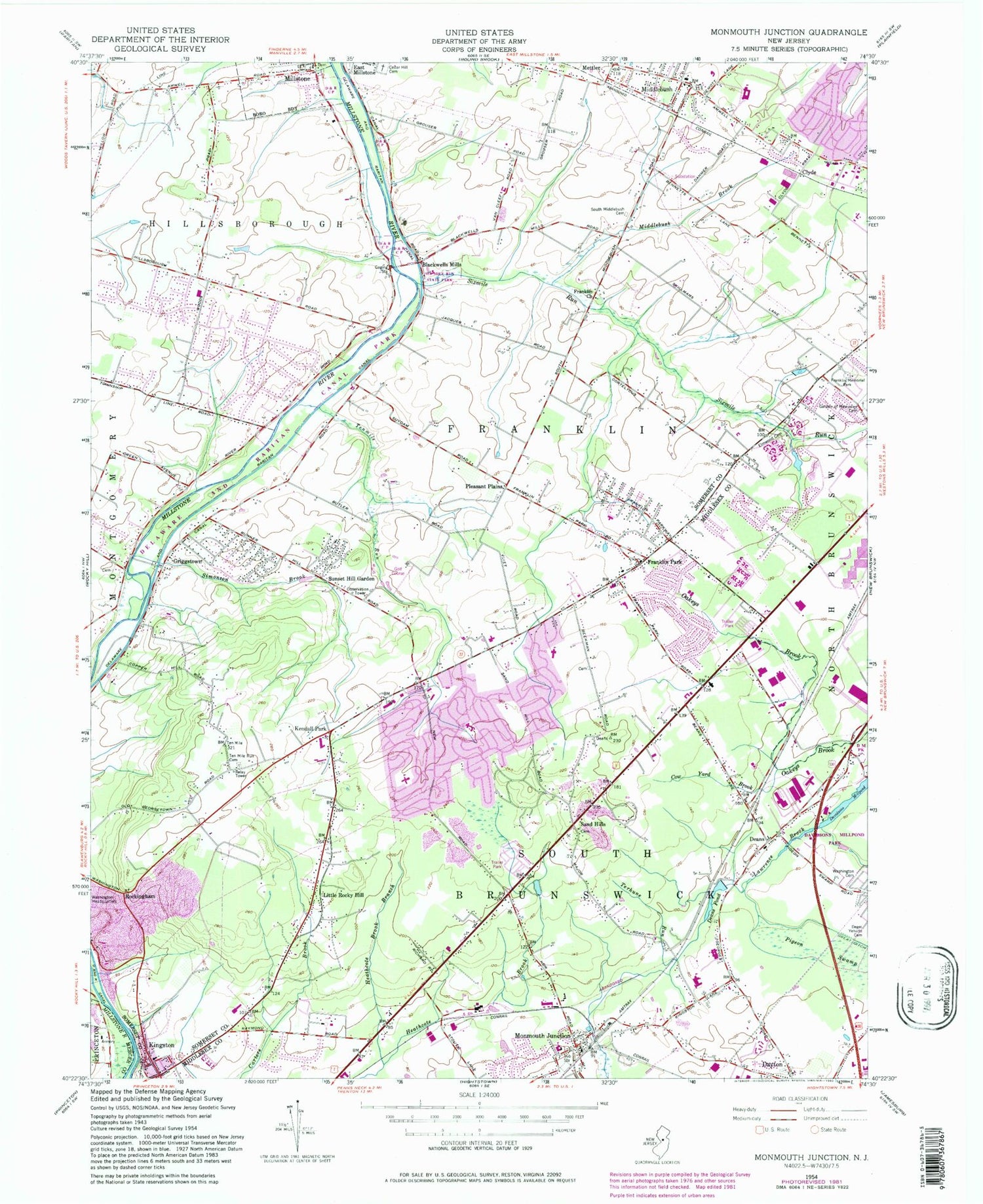
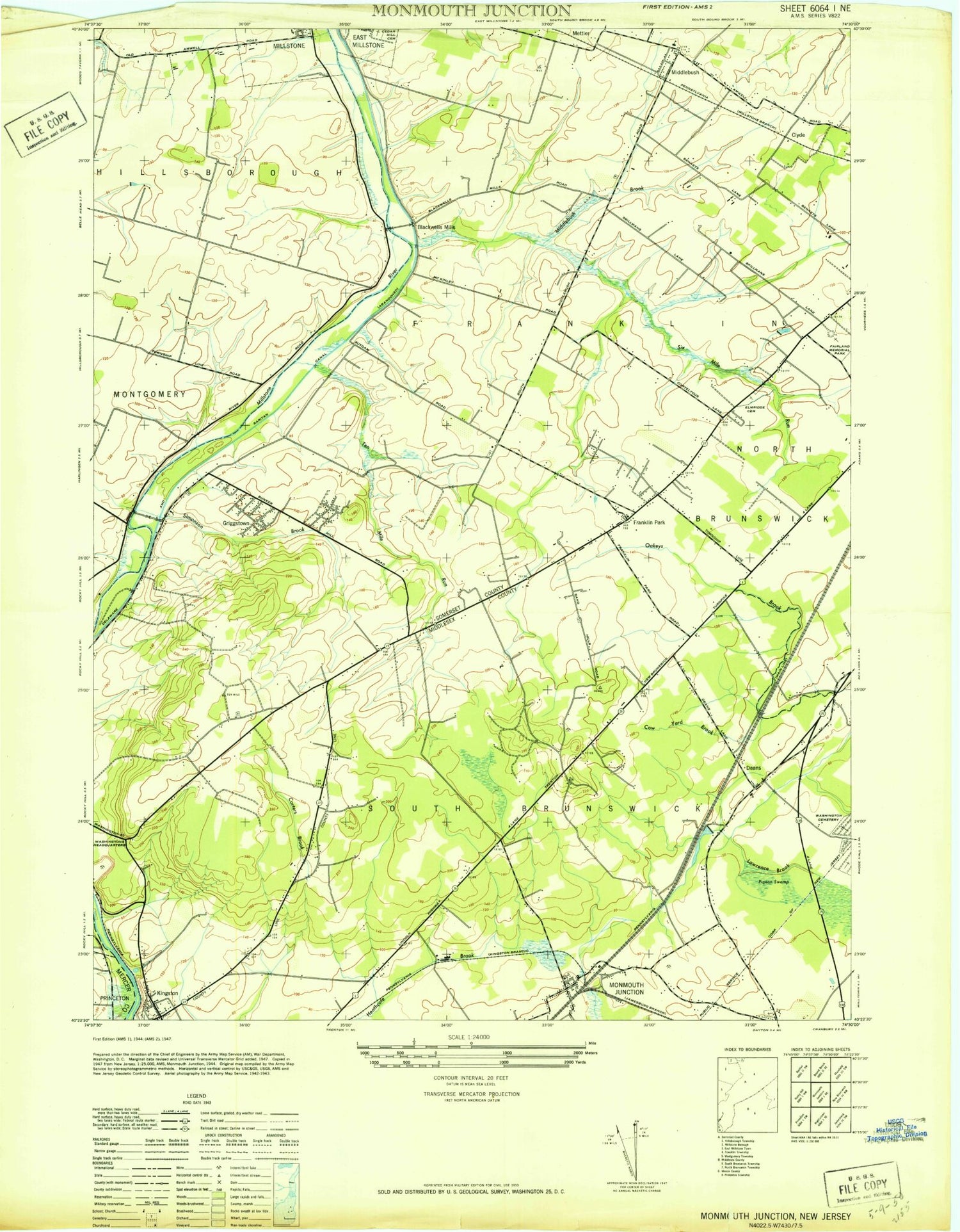
MyTopo
Classic USGS Monmouth Junction New Jersey 7.5'x7.5' Topo Map
Couldn't load pickup availability
Historical USGS topographic quad map of Monmouth Junction in the state of New Jersey. Typical map scale is 1:24,000, but may vary for certain years, if available. Print size: 24" x 27"
This quadrangle is in the following counties: Mercer, Middlesex, Somerset.
The map contains contour lines, roads, rivers, towns, and lakes. Printed on high-quality waterproof paper with UV fade-resistant inks, and shipped rolled.
Contains the following named places: Cedar Hill Cemetery, Clyde, Cow Yard Brook, Davidsons Millpond, Deans, Deans Pond, Elmwood Cemetery, Franklin Church, Franklin Memorial Park, Franklin Park, Garden of Memories, Griggstown, Heathcote Brook Branch, Kendall Park, Kingston, Little Rocky Hill, Mettler, Middlebush, Middlebush Brook, Millstone, Monmouth Junction, Pleasant Plains, Rockingham, Sand Hills, Simonson Brook, Sixmile Run, South Middlebush Cemetery, Sunset Hill Garden, Ten Mile Run Cemetery, Tenmile Run, Terhune Run, Township of South Brunswick, Township of Franklin, Blackwells Mills, Black Horse, Ten Mile Run, South Brunswick Terrace, Sixmile Run, Deans Mills Dam, Society Hill at North Brunswick Heliport, Raritan Center Heliport, Heathcote, Saint Augustine Roman Catholic Church, Brooks Crossing Elementary at Deans School, Brunswick Acres Elementary School, Cambridge Elementary School, Constable Elementary School, Crossroads Middle School North Campus, Crossroads Middle School South Campus, Greenbrook Elementary School, Monmouth Junction Elementary School, Brunswick Acres Park, Hidden Lake Park, Luke Park, Reichler Park, West New Road Park, Kingston Elementary School, Bunker Hill Golf Course, Hillsborough Reformed Church at Millstone, Kingston Presbyterian Church, Middlebush Reformed Church, Reformed Church of Griggstown, Six Mile Run Reformed Church, Franklin Park Elementary School, Sampson G Smith Intermediate School, Woods Road Elementary School, Bunker Hill, Tenmile Run Mountain, Hillsborough Reformed Church Cemetery, Kingston Presbyterian Cemetery, Ninemile Run, Hill Cemetery, Kingston United Methodist Church, Kingston Mall Shopping Center, Robbins Nest Preschool, Brooks Crossing Elementary School, Keyboard Kids Preschool, Sage Day School, ESC Kingston School, Amsterdam Elementary School, Noor-ul-iman School, Oakcrest Academy School, Saint Augustine of Canterbury School, Dayton Census Designated Place, Monmouth Junction Census Designated Place, Heathcote Census Designated Place, Kendall Park Census Designated Place, Kingston Census Designated Place, Blackwells Mills Census Designated Place, Clyde Census Designated Place, East Rocky Hill Census Designated Place, Franklin Park Census Designated Place, Griggstown Census Designated Place, Pleasant Plains Census Designated Place, Six Mile Run Census Designated Place, Ten Mile Run Census Designated Place, Monmouth Junction Volunteer Fire Department Station 20, Middlebush Volunteer Fire Department, Griggstown Volunteer Fire Company, Franklin Park Fire Company, Hillsborough Volunteer Fire Company 3, North Brunswick Volunteer Fire Company 3, Monmouth Junction Volunteer Fire Department Station 21, Kendall Park Volunteer Fire Company Substation, Kendall Park Volunteer Fire Company Station 1, Little Rocky Hill Volunteer Fire Company, Cross Brook, Six Mile Run State Park, Six Mile Run Reservoir Site, Steep Hill Brook, Robert Wood Johnson Medics, Kingston First Aid and Rescue Squad, Monmouth Junction First Aid Squad, Kendall Park First and Aid Rescue Squad, Monmouth Junction First Aid Squad Substation, Kingston Quarry, South Brunswick Police Department, Franklin Township Police Department, Monmouth Junction Post Office, Kingston Post Office, Somerset Post Office, Franklin Park Post Office, Deans Census Designated Place


