MyTopo
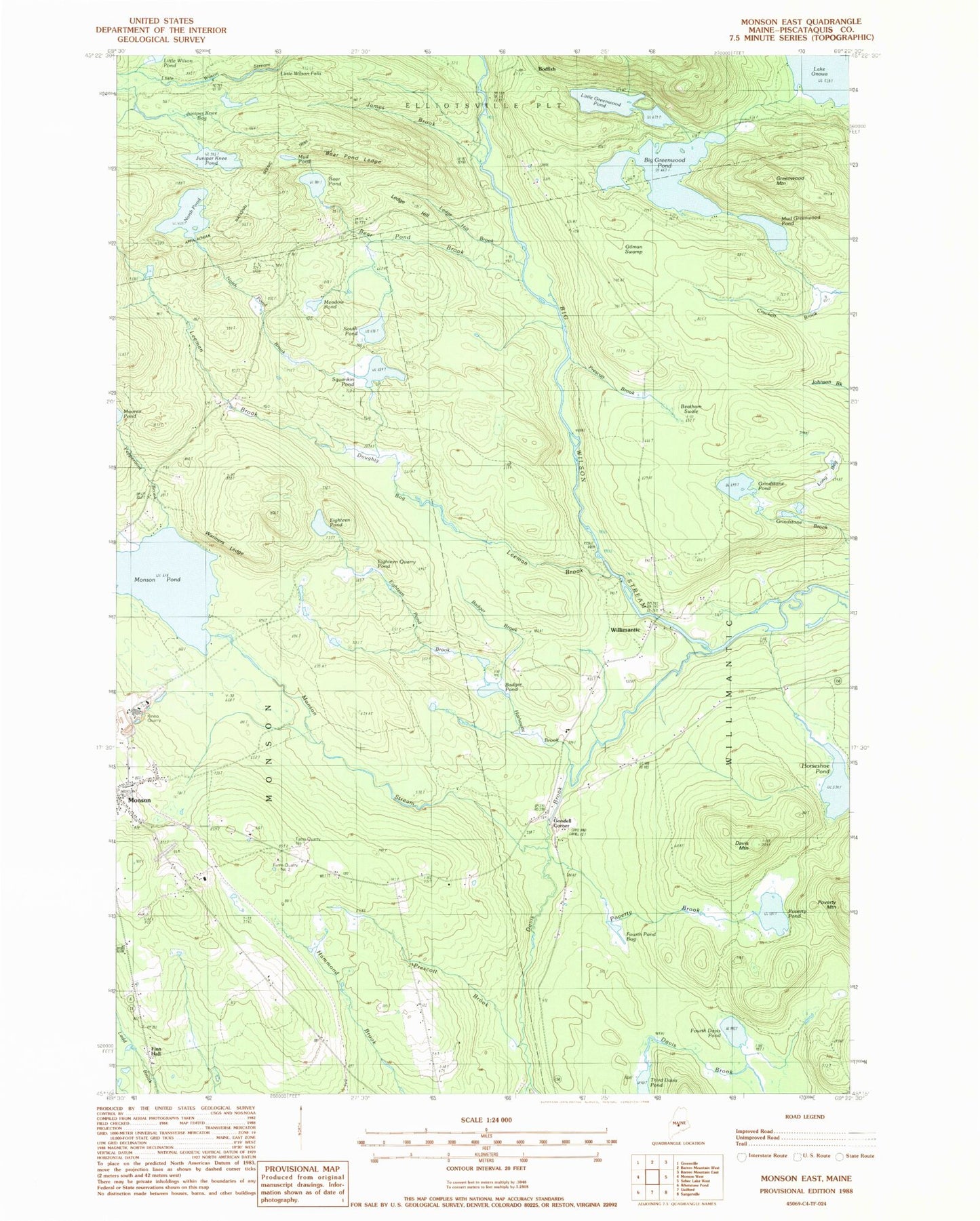
Classic USGS Monson East Maine 7.5'x7.5' Topo Map
Couldn't load pickup availability
Historical USGS topographic quad map of Monson East in the state of Maine. Typical map scale is 1:24,000, but may vary for certain years, if available. Print size: 24" x 27"
This quadrangle is in the following counties: Piscataquis.
The map contains contour lines, roads, rivers, towns, and lakes. Printed on high-quality waterproof paper with UV fade-resistant inks, and shipped rolled.
Contains the following named places: Badger Brook, Badger Pond, Bear Pond, Bear Pond Brook, Bear Pond Ledge, Beetham Swale, Big Greenwood Pond, Davis Brook, Davis Mountain, Doughty Bog, Eighteen Pond, Eighteen Pond Brook, Eighteen Quarry Pond, Farm Quarry Number One, Farm Quarry Number Two, Finn Hall, Fourth Davis Pond, Fourth Pond Bog, Gilman Swamp, Goodell Brook, Greenwood Mountain, Grindstone Pond, Hammond Brook, Hathaway Brook, Hillside Cemetery, Hillside Quarry, Horseshoe Pond, James Brook, Juniper Knee Bog, Juniper Knee Pond, Kineo Quarry, Ledge Hill, Ledge Hill Brook, Leeman Brook, Little Greenwood Pond, Little Wilson Falls, Long Bog, Meadow Pond, Monson Stream, Monson Cemetery, Monson Pond, Mud Greenwood Pond, Mud Pond, North Pond, North Pond Brook, Lake Onawa, Peppermint Brook, Poverty Brook, Poverty Mountain, Poverty Pond, Prescott Brook, Prescott Brook, Riverside Cemetery, South Pond, Sprague School, Squankin Pond, Third Davis Pond, Wariners Ledges, Willimantic, Bodfish, Goodell Corner, Town of Willimantic, Phillips Brooks Dam, Monson Volunteer Fire Department, Elliotsville Cemetery, Monson Public Library