MyTopo
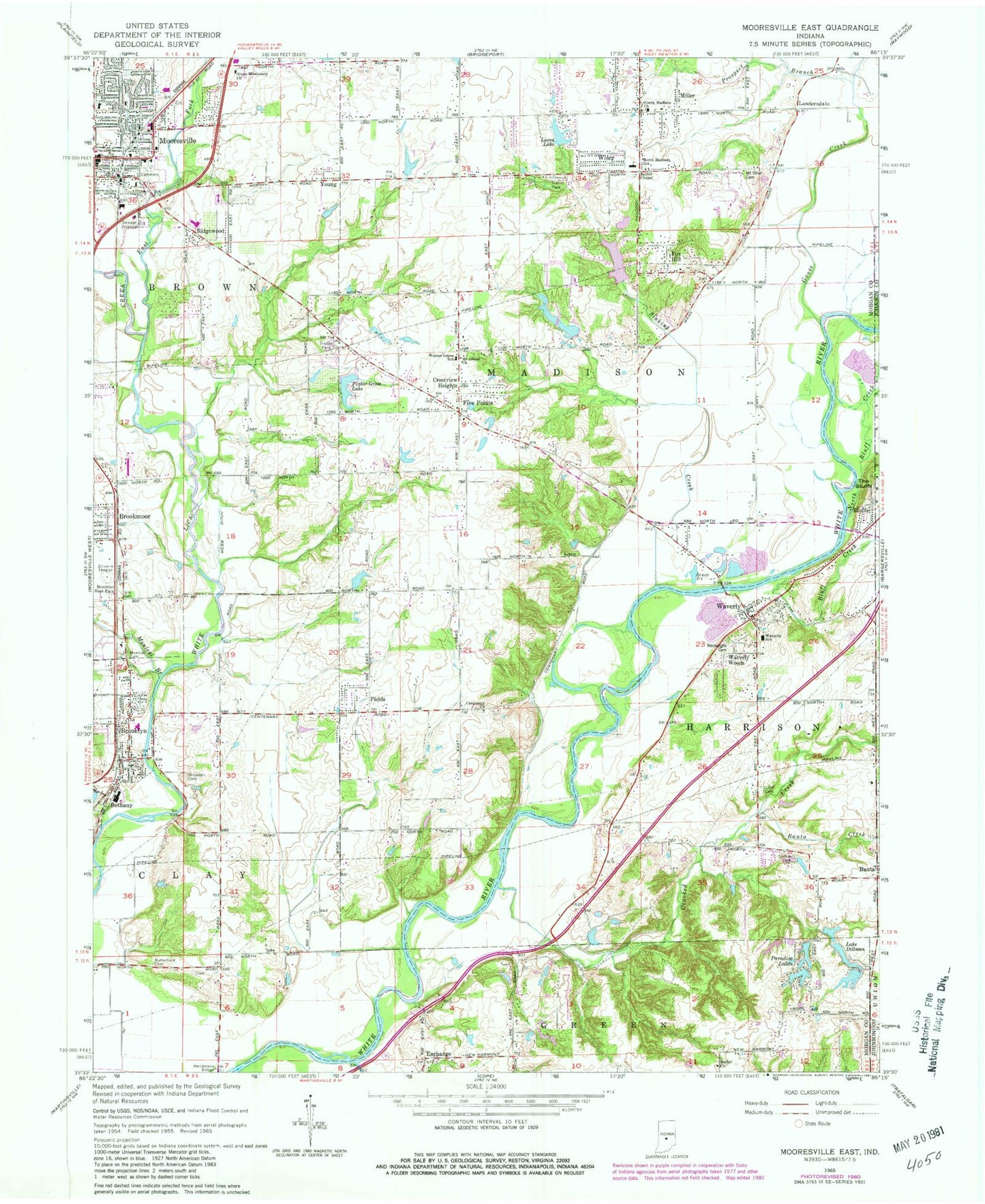
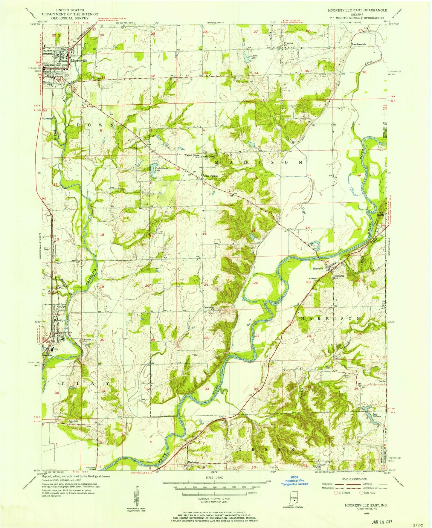
Classic USGS Mooresville East Indiana 7.5'x7.5' Topo Map
Couldn't load pickup availability
Historical USGS topographic quad map of Mooresville East in the state of Indiana. Map scale may vary for some years, but is generally around 1:24,000. Print size is approximately 24" x 27"
This quadrangle is in the following counties: Johnson, Morgan.
The map contains contour lines, roads, rivers, towns, and lakes. Printed on high-quality waterproof paper with UV fade-resistant inks, and shipped rolled.
Contains the following named places: Arens Lake, Arens Lake Dam, Banta, Banta Creek, Bethel Chapel, Bethel Church, Bluff Creek, Bluffs, Brooklyn, Brooklyn Cemetery, Brooklyn Elementary School, Brooklyn Fire Station 41, Brooklyn Police Department, Brooklyn Post Office, Brooklyn Rest Park, Brooklyn Volunteer Fire Department, Brookmoor, Brown Township Fire and Rescue, Brown Township Fire Station, Brown Township Fire Station 22, Centenary Church, Church of Christ of Mooresville, Church of the Ancient Way, Crestview Heights, Crooked Creek, Crossroads Apostolic Church, Crouse Lake, Crouse Lake Dam, East Fork White Lick Creek, Exchange, Fankboner Lake, Fankboner Lake Dam, Fields, First Christian Church, Five Points, Fox Hill, Franciscan Health Mooresville Hospital, Gander Creek, Goose Creek, Grace Missionary Church, Harrison Township Fire Department and Rescue, Independent Order of Odd Fellows Cemetery, Kay Air Airport, Lake Dillman, Landersdale, Leona Lake, Leona Lake Dam, Lower Paradise Lake, Lower Paradise Lake Dam, Lower Spring Lake, Lower Spring Lake Dam, Lower Wildwood Lake Dam, Madison Township Fire Department Station 31, Madison Township Fire Department Station 32, Madison Township Fire Station 31, Mattingly Field, Miller, Monical Branch, Monical Cemetery, Mooresville, Mooresville Cemetery, Mooresville Church of God, Mooresville Fire Department Station 1, Mooresville Police Department, Mount Gilead Church, Mount Olive Cemetery, North Bluff Creek, North Madison Elementary School, North Madison Southern Baptist Church, Old Butterfield Cemetery, Orchard Creek, Owen Field, Paradise Lakes, Poplar Grove Lake, Poplar Grove Lake Dam, Prospect Branch, Ridgewood, Shiloh Cemetery, Sinking Creek, South Lake Dillman, South Lake Dillman Dam, Stotts Creek, Terrace Mobile Home Park, The Bluffs, The Links At Heartland Crossing Golf Course, Town of Brooklyn, Town of Mooresville, Township of Harrison, Township of Madison, Upper Paradise Lake, Upper Paradise Lake Dam, Upper Spring Lake, Upper Spring Lake Dam, Upper Wildwood Lake, Upper Wildwood Lake Dam, Walnut Grove School, Waverly, Waverly Elementary School, Waverly United Methodist Church, Waverly Woods, Web Run, Whetzel Cemetery, Wildwood Lake, Wiser, Young, ZIP Codes: 46111, 46158