MyTopo
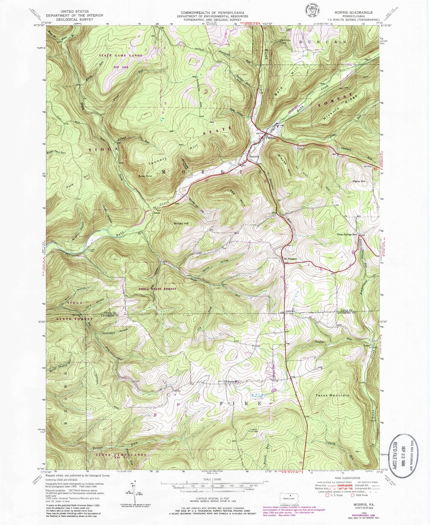
Classic USGS Morris Pennsylvania 7.5'x7.5' Topo Map
Couldn't load pickup availability
Historical USGS topographic quad map of Morris in the state of Pennsylvania. Typical map scale is 1:24,000, but may vary for certain years, if available. Print size: 24" x 27"
This quadrangle is in the following counties: Lycoming, Tioga.
The map contains contour lines, roads, rivers, towns, and lakes. Printed on high-quality waterproof paper with UV fade-resistant inks, and shipped rolled.
Contains the following named places: Opossum Run, Antrim Cemetery, Ayers Hollow, Bald Hill, Basswood Run, Black Run, Blacks Hill, Brill Hollow, Brooks Hill, Brooks Hill Hollow, Brown Point, Campbell Hollow, Custard Run, Dixie Run, East Branch Stony Fork, Fork Hill, Fry Fork, Harrison Run, Hoytville, Hughes Run, Lewis Cemetery, Long Run, Lorenton, McCluskey Hollow, Morris, Mount Pleasant, Number 2 Hollow, Oregon Hill, Paint Run, Plank Hill, Rattler Run, Rock Run, Rock Run, Roland Run, Skunk Hollow, Slide Hollow, Stony Fork, Tannery Hill, Texas Mountain, The Horn, Three Springs Run, Three Springs Run, Tumbling Run, West Branch Stony Fork, Wilcox Run, Williams Trail, Wilson Creek, Windfall Hollow, Zimmerman Creek, Devils Elbow, Oregon Hill Airport (historical), Doane, Texas, Ski Sawmill Ski Area, Tannery Hill Trail, Stony Fork Picnic Area, West Branch Trail, Fork Hill Trail, Stone Quarry Trail, State Game Lands Number 268, Crawford Fire Tower, Township of Morris, Morris Township Fire and Ambulance Company, Morris Post Office, Horn Cemetery, Mount Pleasant Cemetery, Oregon Hill Cemetery, Opossum Run, Antrim Cemetery, Ayers Hollow, Bald Hill, Basswood Run, Black Run, Blacks Hill, Brill Hollow, Brooks Hill, Brooks Hill Hollow, Brown Point, Campbell Hollow, Custard Run, Dixie Run, East Branch Stony Fork, Fork Hill, Fry Fork, Harrison Run, Hoytville, Hughes Run, Lewis Cemetery, Long Run, Lorenton, McCluskey Hollow, Morris, Mount Pleasant, Number 2 Hollow, Oregon Hill, Paint Run, Plank Hill, Rattler Run, Rock Run, Rock Run, Roland Run, Skunk Hollow, Slide Hollow, Stony Fork, Tannery Hill, Texas Mountain, The Horn, Three Springs Run, Three Springs Run, Tumbling Run, West Branch Stony Fork, Wilcox Run, Williams Trail, Wilson Creek, Windfall Hollow, Zimmerman Creek, Devils Elbow, Oregon Hill Airport (historical), Doane, Texas, Ski Sawmill Ski Area, Tannery Hill Trail, Stony Fork Picnic Area, West Branch Trail, Fork Hill Trail, Stone Quarry Trail, State Game Lands Number 268, Crawford Fire Tower, Township of Morris, Morris Township Fire and Ambulance Company, Morris Post Office, Horn Cemetery, Mount Pleasant Cemetery, Oregon Hill Cemetery, Opossum Run, Antrim Cemetery, Ayers Hollow, Bald Hill, Basswood Run, Black Run, Blacks Hill, Brill Hollow, Brooks Hill, Brooks Hill Hollow, Brown Point, Campbell Hollow, Custard Run, Dixie Run, East Branch Stony Fork, Fork Hill, Fry Fork, Harrison Run, Hoytville, Hughes Run, Lewis Cemetery, Long Run, Lorenton, McCluskey Hollow, Morris, Mount Pleasant, Number 2 Hollow, Oregon Hill, Paint Run, Plank Hill, Rattler Run, Rock Run, Rock Run, Roland Run, Skunk Hollow, Slide Hollow, Stony Fork, Tannery Hill, Texas Mountain, The Horn, Three Springs Run, Three Springs Run, Tumbling Run, West Branch Stony Fork, Wilcox Run, Williams Trail, Wilson Creek, Windfall Hollow, Zimmerman Creek, Devils Elbow, Oregon Hill Airport (historical), Doane, Texas, Ski Sawmill Ski Area, Tannery Hill Trail, Stony Fork Picnic Area, West Branch Trail, Fork Hill Trail, Stone Quarry Trail, State Game Lands Number 268, Crawford Fire Tower, Township of Morris, Morris Township Fire and Ambulance Company, Morris Post Office, Horn Cemetery, Mount Pleasant Cemetery, Oregon Hill Cemetery