MyTopo
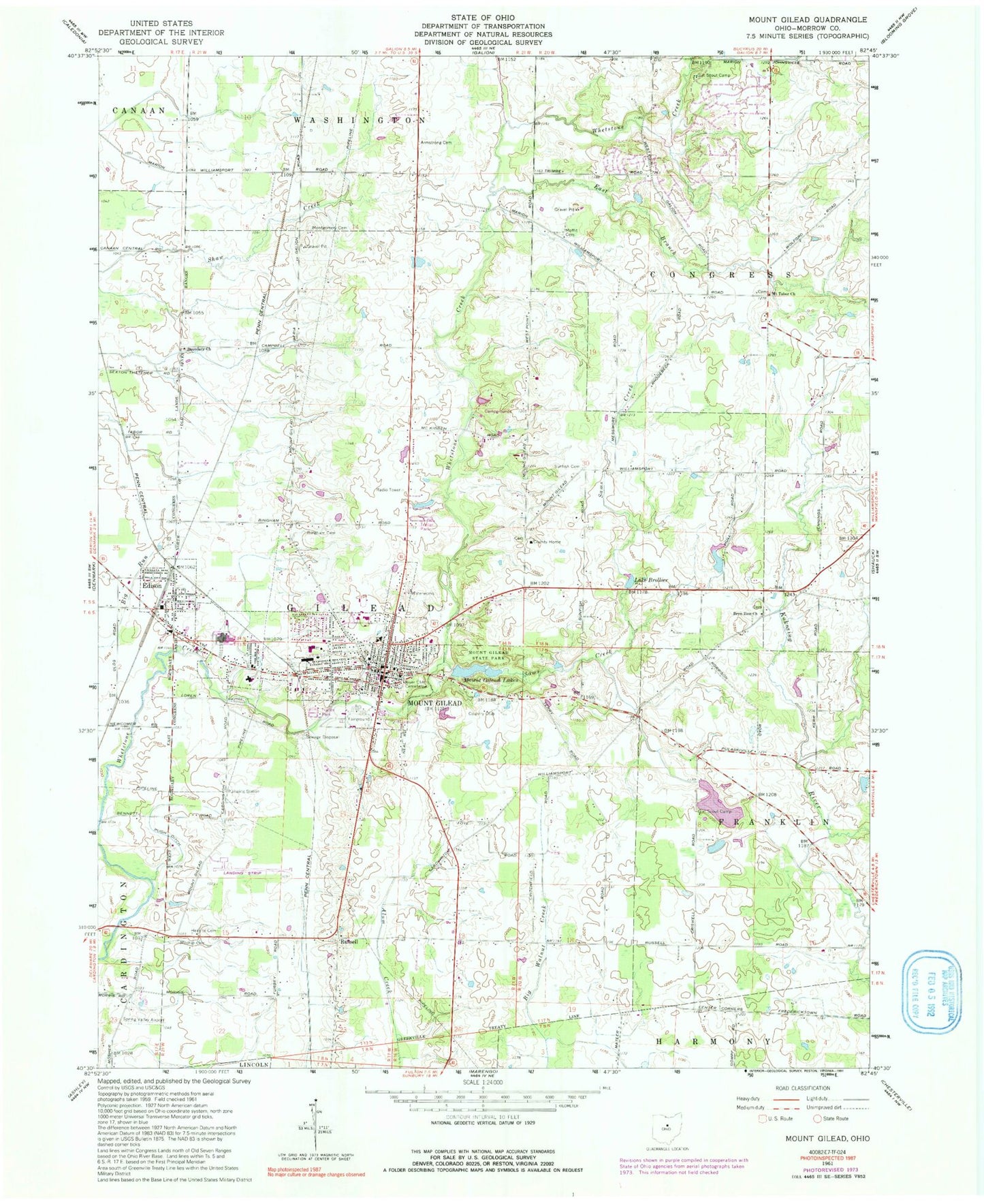
Classic USGS Mount Gilead Ohio 7.5'x7.5' Topo Map
Couldn't load pickup availability
Historical USGS topographic quad map of Mount Gilead in the state of Ohio. Map scale may vary for some years, but is generally around 1:24,000. Print size is approximately 24" x 27"
This quadrangle is in the following counties: Morrow.
The map contains contour lines, roads, rivers, towns, and lakes. Printed on high-quality waterproof paper with UV fade-resistant inks, and shipped rolled.
Contains the following named places: Antiquated Acres, Armstrong Cemetery, Bailey School, Bingham Cemetery, Bluejay School, Boundary Church, Boundary School, Bryn Zion Cemetery, Bryn Zion Church, Candlewood Lake, Candlewood Lake Census Designated Place, Candlewood Lake Dam, County Home Cemetery, Davis School, Dogwood Valley Camp Lake, Dogwood Valley Camp Lake Dam, Dogwood Valley Campground, East Branch Whetstone Creek, Edison, Edison Elementary School, Edison Post Office, Edison United Methodist Church, Fairview School, First Baptist Church, First Presbyterian Church, Friends Cemetery, Frozen Hill School, Gilead Friends Church, Guiding Star School, Harding Area Council BSA Dam, Harding Area Council BSA Reservoir, Hexsite Cemetery, Hidden Lakes, Hidden Lakes Census Designated Place, Johnsville Fire Department Station 2, Lake Brollier, Liberty School, Lone Star School, Maple Grove School, Moffit Cemetery, Mohawk Mobile Estates, Montgomery Cemetery, Morrow County, Morrow County Airport, Morrow County Courthouse, Morrow County Emergency Medical Services, Morrow County Fairgrounds, Morrow County Home, Morrow County Hospital, Morrow County Sheriff's Office, Mosher Cemetery, Mount Gilead, Mount Gilead Church of the Nazarene, Mount Gilead Elementary School, Mount Gilead Fire Department Station 19, Mount Gilead High School, Mount Gilead Junior High School, Mount Gilead Lakes, Mount Gilead Lower Lake, Mount Gilead Lower Lake Dam, Mount Gilead Police Department, Mount Gilead Post Office, Mount Gilead Primary School, Mount Gilead State Park, Mount Gilead Upper Lake, Mount Gilead Upper Lake Dam, Mount Tabor Church, Mount Tabor Methodist Episcopal Cemetery, Northgate Mobile Home Park, Pine Lakes Golf Club, Pugh Ditch, River Cliff Cemetery, Russell, Sams Creek, School Number 5, School Number 6, Shaffer Farm, Spring Valley Airport, Straits Lake, Straits Lake Dam, Sunfish Cemetery, Sunfish School, Surprise, Surprise Post Office, Township of Gilead, Trinity United Methodist Church, Union Cemetery, Village of Edison, Village of Mount Gilead, Westview Mobile Home Park, Whetstone Trailer Park, White Eagle School, ZIP Code: 43338