
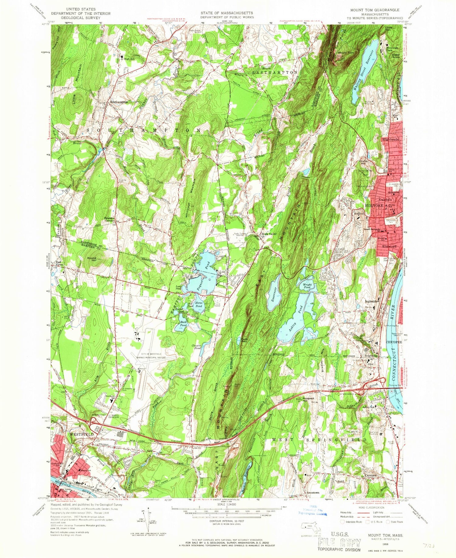
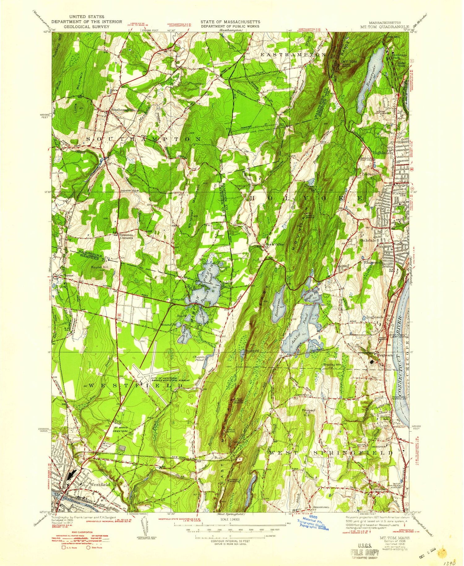
MyTopo
Classic USGS Mount Tom Massachusetts 7.5'x7.5' Topo Map
Couldn't load pickup availability
Historical USGS topographic quad map of Mount Tom in the state of Massachusetts. Map scale may vary for some years, but is generally around 1:24,000. Print size is approximately 24" x 27"
This quadrangle is in the following counties: Hampden, Hampshire.
The map contains contour lines, roads, rivers, towns, and lakes. Printed on high-quality waterproof paper with UV fade-resistant inks, and shipped rolled.
Contains the following named places: Amostown, Apremont Park, Arm Brook, Arm Brook Dam, Arm Brook Reservoir, Ashley Cemetery, Ashley Cutoff, Ashley Elementary School, Ashley Pond, Ashley Pond Dam, Ashleyville, Barry Brook, Bashista Orchards, Bear Hole Heliport, Bearhole Reservoir, Bearhole Reservoir Dam, Bible Baptist Church, Blessed Sacrament Church, Blessed Sacrament School, Bradley Mountain, Brickyard Brook, Brightside, Brush Hill Mobile Home Park, Buck Pond, Bush Brook, Bush Notch, Calvary Cemetery, Cayenne, Cedar Knob, Cedar Pond, Chapin Pond, Chapin Pond Dam, Chapman Playground, Childrens Home, City of Holyoke, City of West Springfield Town, Clear Pond, Clear Pond Dam, Clear Pond West Dike, Conant Memorial Park, Connor Reservoir, Crafts Hill, Crowfoot Brook, Digital Heliport, Doctor William R Peck School, Doe Pond, Dominican Monastery, E N White School, East Farms, East Mountain, East Mountain Country Club, East Mountain Ski Touring Center, Elmwood Park, First Baptist Church, First Lutheran Church, First Lutheran School, Forestdale Cemetery West, Full Gospel Church, Gloutak Park, Goldine Brook, Hackmatack Swamp, Hampden County, Hampden Plaza, Hampton Ponds, Hampton Ponds State Park, High Service Reservoir, Holy Trinity School, Holyoke Community College Library, Holyoke Crossing Shopping Center, Holyoke Fire Department Station 3, Holyoke Fire Department Station 5, Holyoke Fire Department Station 6, Holyoke Mall, Holyoke Mall at Ingleside, Holyoke Mall at Ingleside Shopping Center, Holyoke Mall Shopping Center, Holyoke Medical Center, Holyoke Mini-Mall, Horse Pond, Horse Pond Dam, Ingleside, Ingleside Mall Post Office, John J Lynch Middle School, John R Fausey Elementary School, Kenny Park, Kirtland School, Lieutenant Clare Sullivan School, Lieutenant Elmer J McMahon School, Little Mountain, Long Pond, Lost Pond, Lyman Mill Pond Dam, Lyman Pond, Massachusetts State Police Station B8 Westfield Barracks, Maurice A Donahue School, Mayer Field, McLean Reservoir, McLean Reservoir Dam, Metcalf Elementary School, Moose Brook, Moseley Elementary School, Moseley Elementary School Media Center, Mount Tom, Mount Tom Ski and Recreation Area, Mountain Park, Owen District, Paper Mill Elementary School, Paper Mill Elementary School Media Center, Pequot Pond, Pilsuoski Park, Potash Brook, Powdermill Brook Dam, Powdermill Brook Reservoir, Prospect Hill, Prospect Hill School, Providence Behavioral Health Hospital, Pulaski Park, Ram Ambulance, Red Brook, Riverdale Shopping Center, Rock Valley, Rock Valley Cemetery, Round Hill, Round Pond, Saint Jerome Cemetery, Saint Josephs Cemetery, Saint Marys Cemetery, Saint Peters Lutheran Church, Schoolhouse Brook, Scott Tower, Sholom School, Snake Pond, Soldier's Home in Holyoke, Southampton, Southampton Center Cemetery, Southampton Center Historic District, Southampton Country Club, Southampton Fire Department Station 1 Headquarters, Southampton Fire Department Station 2, Southampton Police Department, Southampton Post Office, Southampton Road Elementary School, Southampton Road School, Southampton Town Hall, Springdale Pond, Springfield Country Club Dam, Swanson Corners, Tannery Brook, Town of Southampton, Trask Brook, Tripple Brook, WCCH-FM (Holyoke), West Springfield Fire Department Station 3, Westfield, Westfield Assembly of God Church, Westfield Fire Department Station 3, Westfield-Barnes Regional Airport, WGBY-TV (Springfield), WGGB-TV (Springfield), Whip City Speedway, Whiteloaf Mountain, Whiting Street Pond Dam, Whiting Street Reservoir, WHYN-AM (Springfield), WHYN-FM (Springfield), William E Norris School, Wright Cutoff, Wright Pond, Wyatt Harper Park, Wyckoff Park Country Clubv, ZIP Codes: 01040, 01073, 01089


