MyTopo
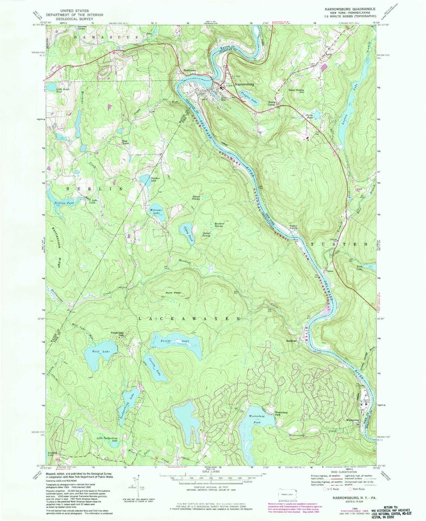
Classic USGS Narrowsburg New York 7.5'x7.5' Topo Map
Couldn't load pickup availability
Historical USGS topographic quad map of Narrowsburg in the states of New York, Pennsylvania. Typical map scale is 1:24,000, but may vary for certain years, if available. Print size: 24" x 27"
This quadrangle is in the following counties: Pike, Sullivan, Wayne.
The map contains contour lines, roads, rivers, towns, and lakes. Printed on high-quality waterproof paper with UV fade-resistant inks, and shipped rolled.
Contains the following named places: Clarks Pond, Deep Hollow Hill, East Branch Tenmile River, Feagles Lake, Glen Cove Cemetery, Grassy Swamp Brook, Lava Cemetery, Luxton Lake, Narrowsburg, Saint Francis Church, Tenmile River, Tusten Cemetery, Tusten Station, Hunts Corner, Lava, Tusten, Saint Francis Xavier Cemetery, Narrowsburg Census Designated Place, Tusten Volunteer Ambulance Service, Narrowsburg Fire Department, Lava Volunteer Fire Department, Narrowsburg Post Office, Rattlesnake Ridge, Westcolang Park, Atco, Beach Lake Creek, Camp Colang, Cattail Swamp, Cobey Pond, Corilla Lake, Darbytown, Forest Lake, Little Beach Pond, Little Teedyuskung Lake, Masthope, Masthope Creek, Panther Lake, Peggy Run, Perkins Pond, Point Peter, Rattlesnake Creek, Rowland Swamp, Spruce Swamp, Teedyuskung Lake, Welcome Lake, Westcolang Creek, Wolf Lake, Wolf Lake Run, Westcolang Lake Dam, Forest Lake Dam, Cobey Dam, Simmons School, Forest Lake Park, Westcolang Pond, Darbytown Falls, East Berlin, Westcolang, Masthope Ski Area, Perkins Pond Dam, Masthope Rapids, Fawn Lake Forest, Branningville, Fawn Lake Forest Census Designated Place, Masthope Census Designated Place, Central Volunteer Fire Department Station 27, Welcome Lake Fire and Rescue Station 26, Lackawaxen Township Volunteer Ambulance Service Bohemia Station, Clarks Pond, Deep Hollow Hill, East Branch Tenmile River, Feagles Lake, Glen Cove Cemetery, Grassy Swamp Brook, Lava Cemetery, Luxton Lake, Narrowsburg, Saint Francis Church, Tenmile River, Tusten Cemetery, Tusten Station, Hunts Corner, Lava, Tusten, Saint Francis Xavier Cemetery, Narrowsburg Census Designated Place, Tusten Volunteer Ambulance Service, Narrowsburg Fire Department, Lava Volunteer Fire Department, Narrowsburg Post Office, Rattlesnake Ridge, Westcolang Park, Atco, Beach Lake Creek, Camp Colang, Cattail Swamp, Cobey Pond, Corilla Lake, Darbytown, Forest Lake, Little Beach Pond, Little Teedyuskung Lake, Masthope, Masthope Creek, Panther Lake, Peggy Run, Perkins Pond, Point Peter, Rattlesnake Creek, Rowland Swamp, Spruce Swamp, Teedyuskung Lake, Welcome Lake, Westcolang Creek, Wolf Lake, Wolf Lake Run, Westcolang Lake Dam, Forest Lake Dam, Cobey Dam, Simmons School, Forest Lake Park, Westcolang Pond, Darbytown Falls, East Berlin, Westcolang, Masthope Ski Area, Perkins Pond Dam, Masthope Rapids, Fawn Lake Forest, Branningville, Fawn Lake Forest Census Designated Place, Masthope Census Designated Place, Central Volunteer Fire Department Station 27, Welcome Lake Fire and Rescue Station 26, Lackawaxen Township Volunteer Ambulance Service Bohemia Station