MyTopo
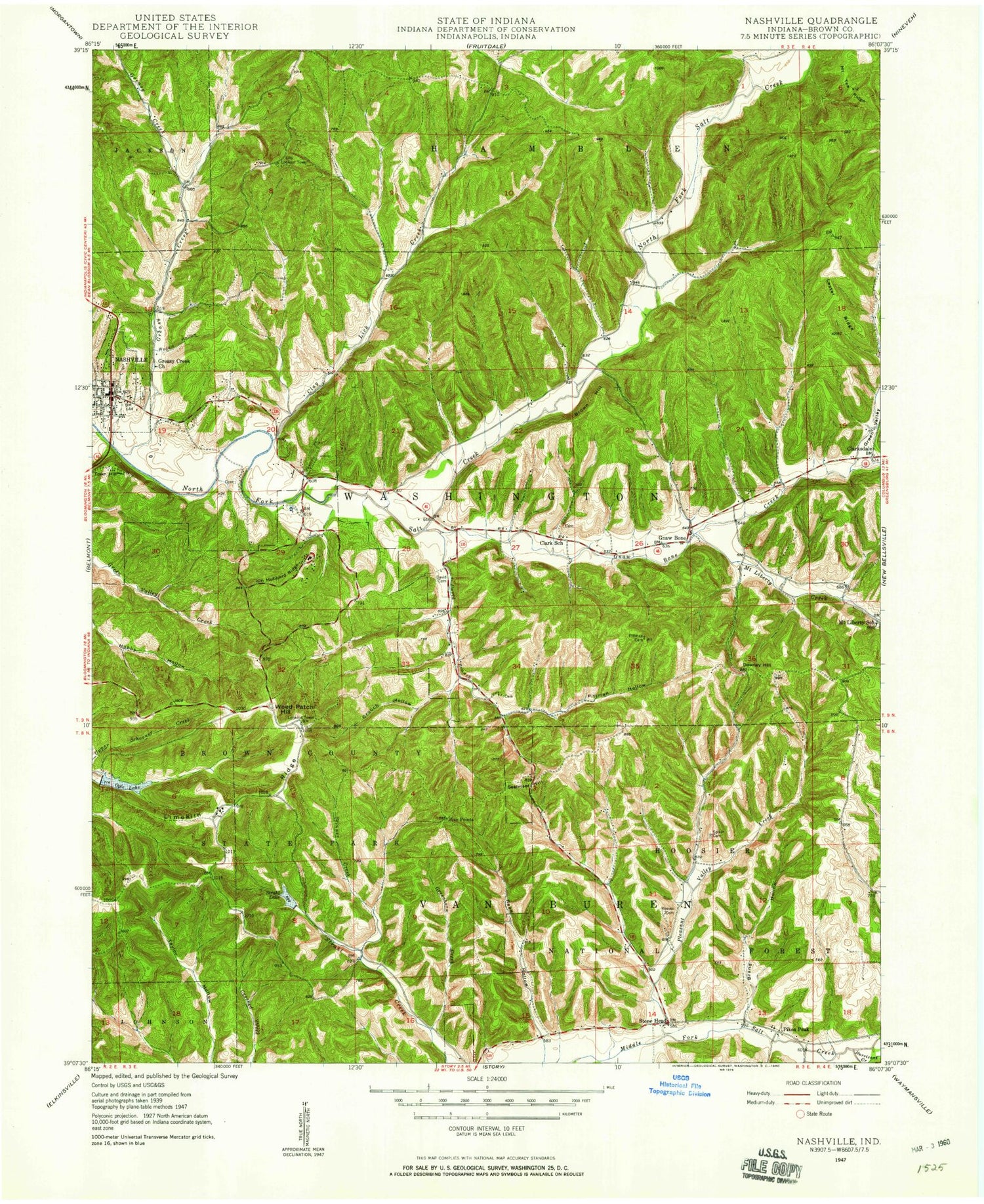
Classic USGS Nashville Indiana 7.5'x7.5' Topo Map
Couldn't load pickup availability
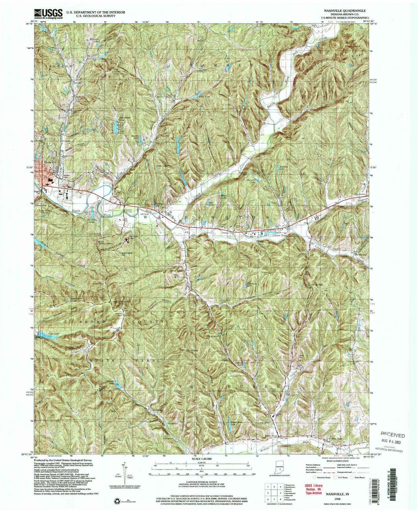
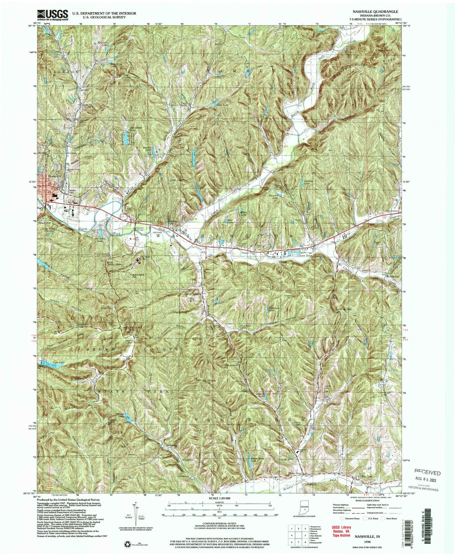
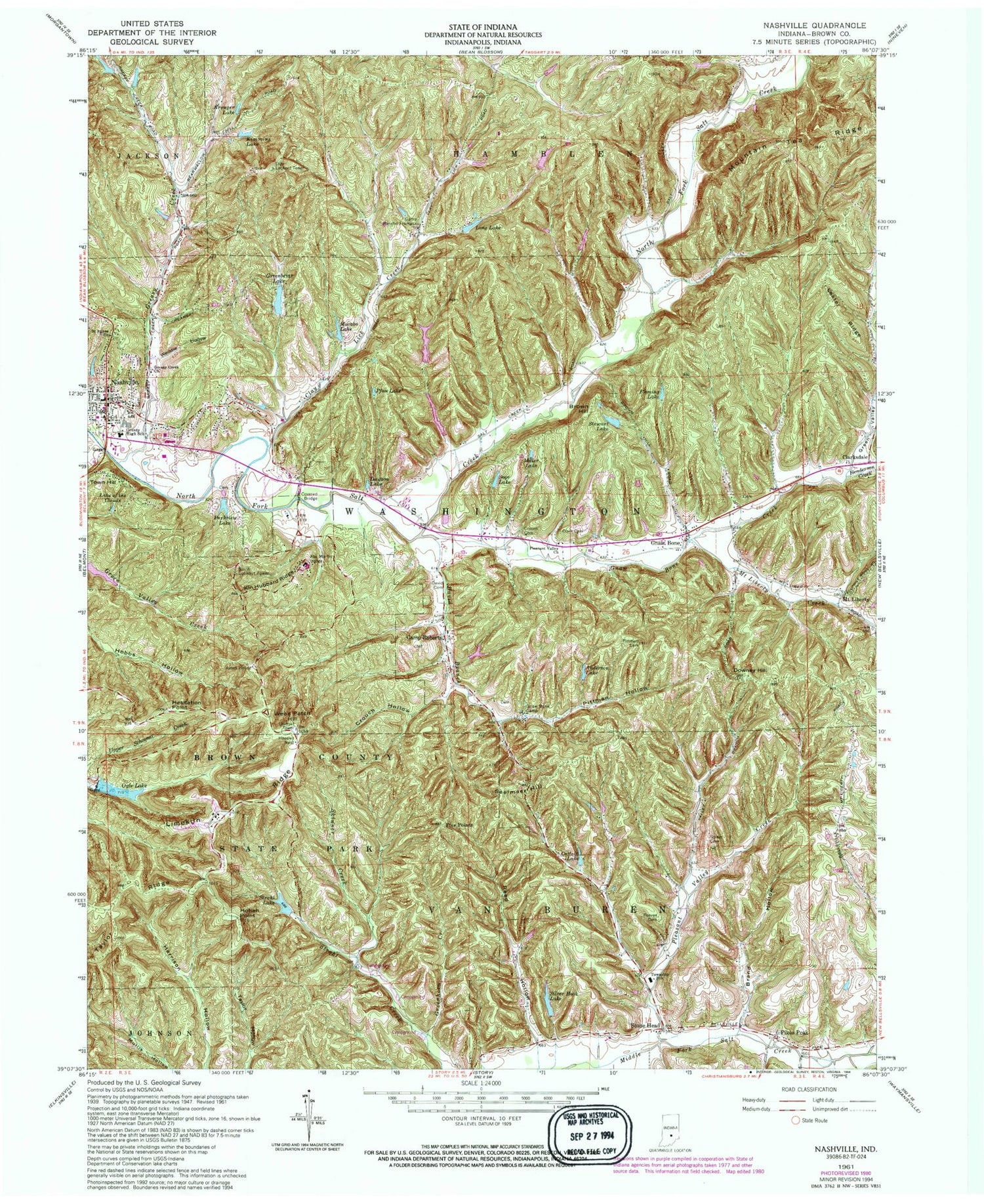
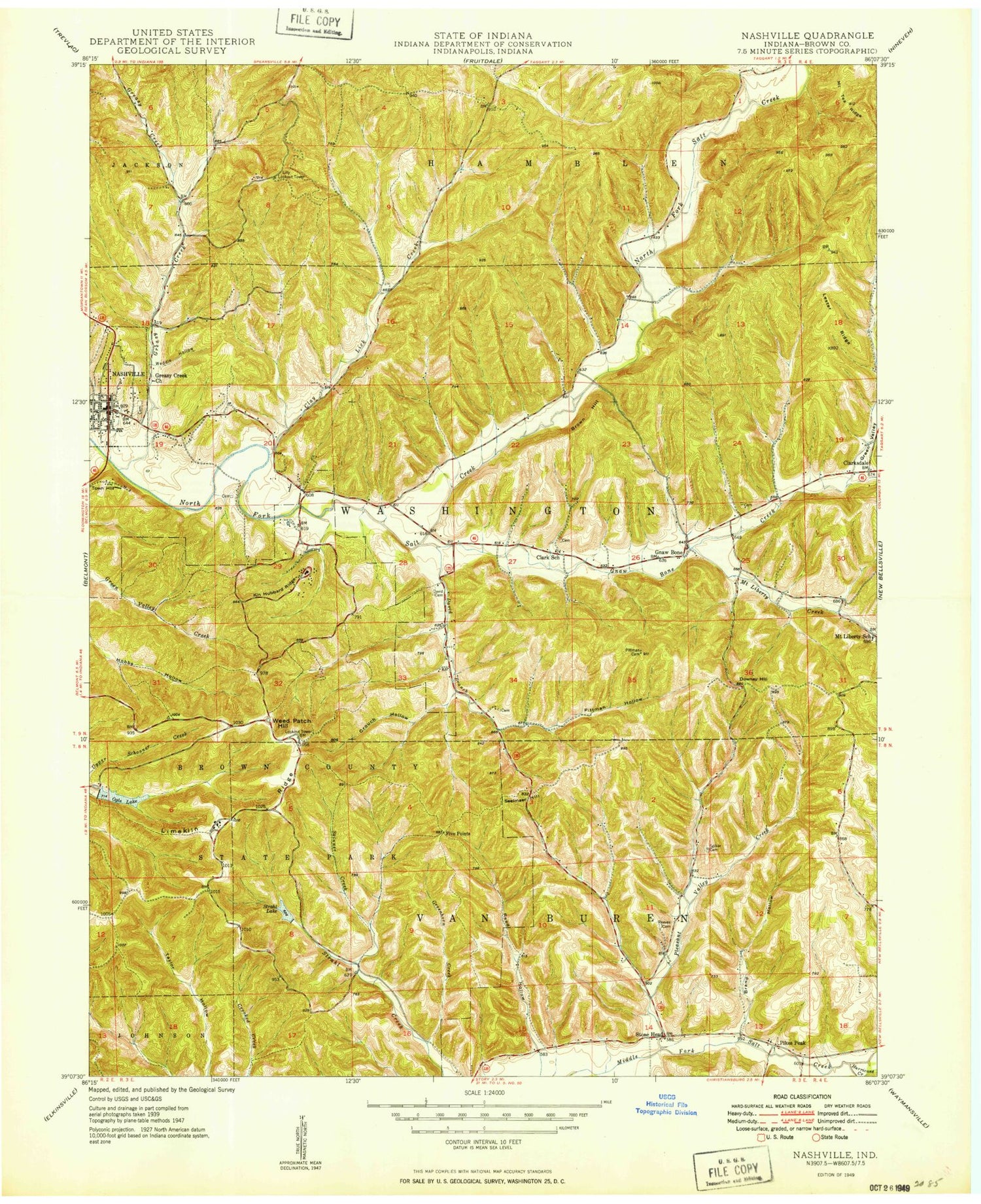
Historical USGS topographic quad map of Nashville in the state of Indiana. Typical map scale is 1:24,000, but may vary for certain years, if available. Print size: 24" x 27"
This quadrangle is in the following counties: Brown.
The map contains contour lines, roads, rivers, towns, and lakes. Printed on high-quality waterproof paper with UV fade-resistant inks, and shipped rolled.
Contains the following named places: Abe Martin Lodge, Anderson Lake, Brand Hollow, Brown Hill, Camp Rancho Framasa, Camp Roberts, Clark Cemetery, Clarksdale, Clay Lick Creek, Crouch Cemetery, Crouch Hollow, David Branch, David Cemetery, Dawson Lake, Downey Hill, Five Points, Fleming Lake, Gnaw Bone Camp, Gnaw Bone Creek, Greasy Creek, Green Valley, Greenbriar Lake, Greenhorn Creek, Henderson Creek, Hesitation Point, Hohen Point, Kimmins Lake, Kin Hubbard Ridge, Kreuger Lake, Lake of the Clouds, Lester Ridge, Lilly Lookout Tower, Limekiln Ridge, Long Lake, Macabo Lake, Miller Lake, Mount Liberty, Mount Liberty Creek, Mountain Tea Ridge, Ogle Lake, Ortleib Lake, Parkview Lake, Pfau Lake, Pittman Cemetery, Pittman Hollow, Pleasant Valley Church, Pleasant Valley Creek, Reed Hollow, Reeves Cemetery, Sage Lake, Saint Agnes Church, Seelmaer Hill, Silver Hook Lake, Skinner Creek, Spiker Cemetery, Stewart Lake, Stone Head, Taylor Ridge, Town Hill, Weddle Hollow, Weed Patch Hill, Brown County High School, Berry Farm Lake, Kahn Lake Dam, Kahn Lake, Nicewander Lake Dam, Nicewander Lake, Silver Hook Lake Dam, Fleming Lake Dam, Stewart Lake Dam, Willcraft Lake Lower Dam, Ode Lake, Millers Lake Dam, Millers Lake, Pfau Lake Dam, Ogle Lake Dam, Greenbriar Lake Estates Dam, Parkview Lake Dam, Strahl Lake, Strahl Lake Dam, Sage Lake Dam, Pikes Peak, Brown County, Gnaw Bone, Greasy Creek Church, Town of Nashville, Brown County Volunteer Fire Department, Rising Hope Baptist Church, Nashville Police Department, Brown County Sheriff's Office, Nashville Post Office, Abe Martin Lodge, Anderson Lake, Brand Hollow, Brown Hill, Camp Rancho Framasa, Camp Roberts, Clark Cemetery, Clarksdale, Clay Lick Creek, Crouch Cemetery, Crouch Hollow, David Branch, David Cemetery, Dawson Lake, Downey Hill, Five Points, Fleming Lake, Gnaw Bone Camp, Gnaw Bone Creek, Greasy Creek, Green Valley, Greenbriar Lake, Greenhorn Creek, Henderson Creek, Hesitation Point, Hohen Point, Kimmins Lake, Kin Hubbard Ridge, Kreuger Lake, Lake of the Clouds, Lester Ridge, Lilly Lookout Tower, Limekiln Ridge, Long Lake, Macabo Lake, Miller Lake, Mount Liberty, Mount Liberty Creek, Mountain Tea Ridge, Ogle Lake, Ortleib Lake, Parkview Lake, Pfau Lake, Pittman Cemetery, Pittman Hollow, Pleasant Valley Church, Pleasant Valley Creek, Reed Hollow, Reeves Cemetery, Sage Lake, Saint Agnes Church, Seelmaer Hill, Silver Hook Lake, Skinner Creek, Spiker Cemetery, Stewart Lake, Stone Head, Taylor Ridge, Town Hill, Weddle Hollow, Weed Patch Hill, Brown County High School, Berry Farm Lake, Kahn Lake Dam, Kahn Lake, Nicewander Lake Dam, Nicewander Lake, Silver Hook Lake Dam, Fleming Lake Dam, Stewart Lake Dam, Willcraft Lake Lower Dam, Ode Lake, Millers Lake Dam, Millers Lake, Pfau Lake Dam, Ogle Lake Dam, Greenbriar Lake Estates Dam, Parkview Lake Dam, Strahl Lake, Strahl Lake Dam, Sage Lake Dam, Pikes Peak, Brown County, Gnaw Bone, Greasy Creek Church, Town of Nashville, Brown County Volunteer Fire Department, Rising Hope Baptist Church, Nashville Police Department, Brown County Sheriff's Office, Nashville Post Office, Abe Martin Lodge, Anderson Lake, Brand Hollow, Brown Hill, Camp Rancho Framasa, Camp Roberts, Clark Cemetery, Clarksdale, Clay Lick Creek, Crouch Cemetery, Crouch Hollow, David Branch, David Cemetery, Dawson Lake, Downey Hill, Five Points, Fleming Lake, Gnaw Bone Camp, Gnaw Bone Creek, Greasy Creek, Green Valley, Greenbriar Lake, Greenhorn Creek, Henderson Creek, Hesitation Point, Hohen Point, Kimmins Lake, Kin Hubbard Ridge, Kreuger Lake, Lake of the Clouds, Lester Ridge, Lilly Lookout Tower, Limekiln Ridge, Long Lake, Macabo Lake, Miller Lake, Mount Liberty, Mount Liberty Creek, Mountain Tea Ridge, Ogle Lake, Ortleib Lake, Parkview Lake, Pfau Lake, Pittman Cemetery, Pittman Hollow, Pleasant Valley Church, Pleasant Valley Creek, Reed Hollow, Reeves Cemetery, Sage Lake, Saint Agnes Church, Seelmaer Hill, Silver Hook Lake, Skinner Creek