MyTopo
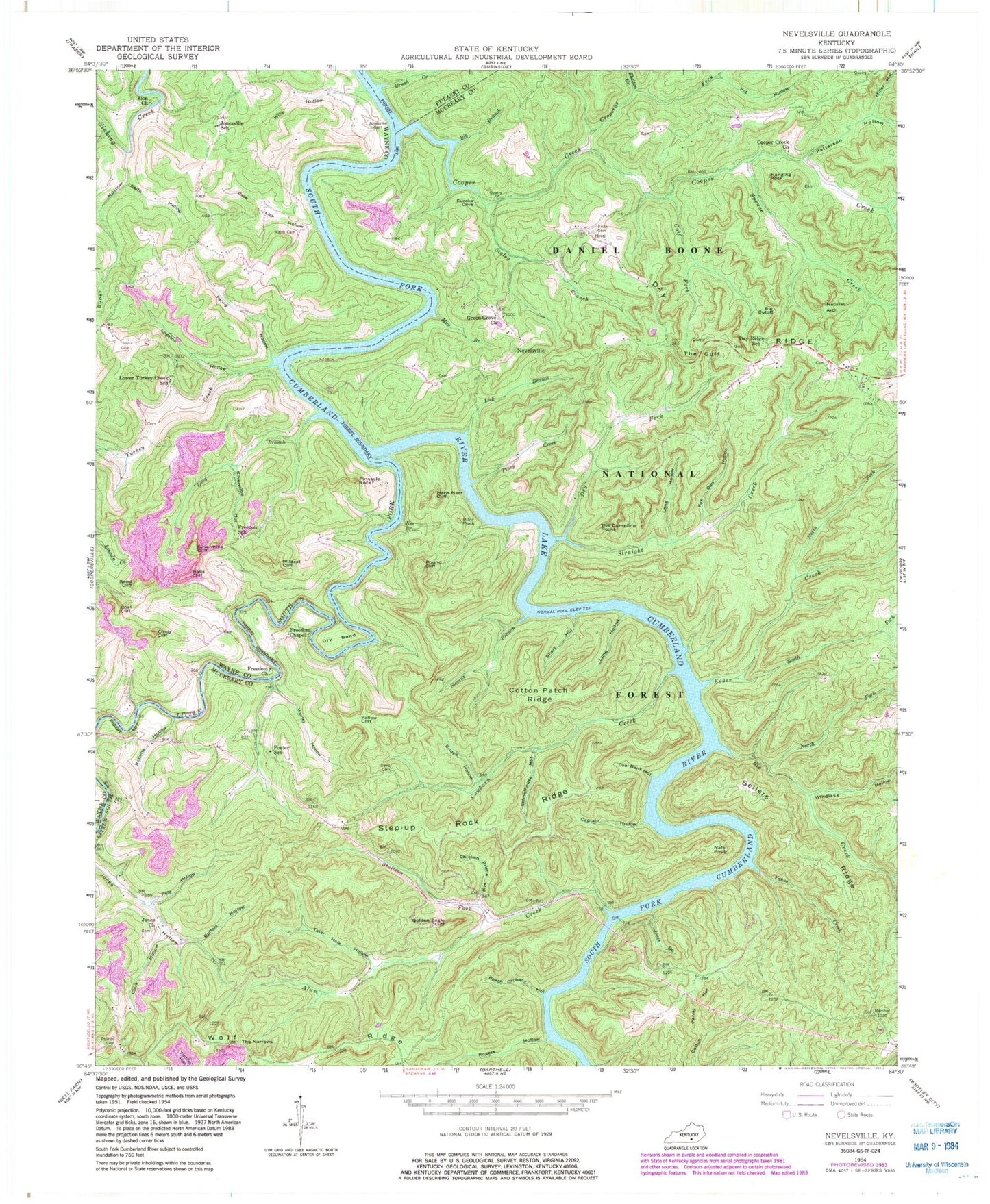
Classic USGS Nevelsville Kentucky 7.5'x7.5' Topo Map
Couldn't load pickup availability
Historical USGS topographic quad map of Nevelsville in the state of Kentucky. Typical map scale is 1:24,000, but may vary for certain years, if available. Print size: 24" x 27"
This quadrangle is in the following counties: McCreary, Pulaski, Wayne.
The map contains contour lines, roads, rivers, towns, and lakes. Printed on high-quality waterproof paper with UV fade-resistant inks, and shipped rolled.
Contains the following named places: Alum Creek, Balls Cliff, Big Branch, Big Creek, Big Cutoff, Bridge Hollow, Brush Creek, Buffalo Hollow, Captain Hollow, Chicken Bristle Hollow, Cindy Cliff, Clark Hollow, Coal Bank Hollow, Coal Cliff, Cooper Creek, Cooper Creek Church, Copperas Fork, Cotton Patch Ridge, Cowhorn Creek, Cutoff Branch, Davis Cemetery, Day Ridge, Day Ridge School, Dry Bend, Dry Fork, Fanny Hollow, Foster School, Fox Den Hollow, Freedom Chapel, Freedom Church, Freedom School, Golden Eagle Cliff, Green Grove Church, Gulf Fork, Hanging Rock, Hens Nest Cliff, Jim Branch, Jones Branch, Jones Church, Jonesville Cemetery, Jonesville School, Keith Cemetery, Keith Cemetery, Keith Hollow, Koger Creek, Lick Branch, Little South Fork, Logston Hollow, Long Branch, Long Hollow, Long Hollow, Lower Turkey Creek School, Mile Branch, Miller Hollow, Morton Station, Nats Knob, Natural Arch, Nevelsville, North Fork Big Creek, North Fork Koger Creek, Patterson Hollow, Peach Orchard Hollow, Pete Hollow, Phillips Cemetery, Pilot Rock, Piney Creek, Pinnacle Rock, Pot Hollow, Pound Cliff, Roberts Hollow, Rogers Hollow, Sand Cliff, Schoolhouse Hollow, Sellers Ridge, Shelton Creek, Short Hollow, Silvermine Cliff, Silvermine Hollow, South Fork Koger Creek, Spruce Creek, Staley Branch, Stallion Fork, Stevens Branch, Straight Creek, Super Hollow, Tater Hole Hollow, The Dumpling Rocks, The Gulf, The Narrows, Turkey Creek, Wildcat Cliff, Willy Hollow, Windlass Hollow, Worley Hollow, Yahoo Creek, Yellow Cliff, Zion Church, Care Lick Hollow, Natural Arch Scenic Area, Day Ridge Church, Yahoo Falls Scenic Area, Morrow Hollow, Step-up Rock Ridge, Alum Recreation Site, Cotton Patch Recreation Site, Straight Creek Recreation Site, Alton Cemetery, Branscum Cemetery, Brocade Post Office (historical), Davy Cad Cemetery, Flosie Post Office (historical), Freedom Cemetery, Gilson-Keith Cemetery, Gran Young Graveyard, Jane Keith Cemetery, Little Wildcat Cliff, Lower Turkey Creek Baptist Church Cemetery, Lower Turkey Creek Church (historical), Maxwell Cemetery, New Cemetery, Silvermine Spring