MyTopo
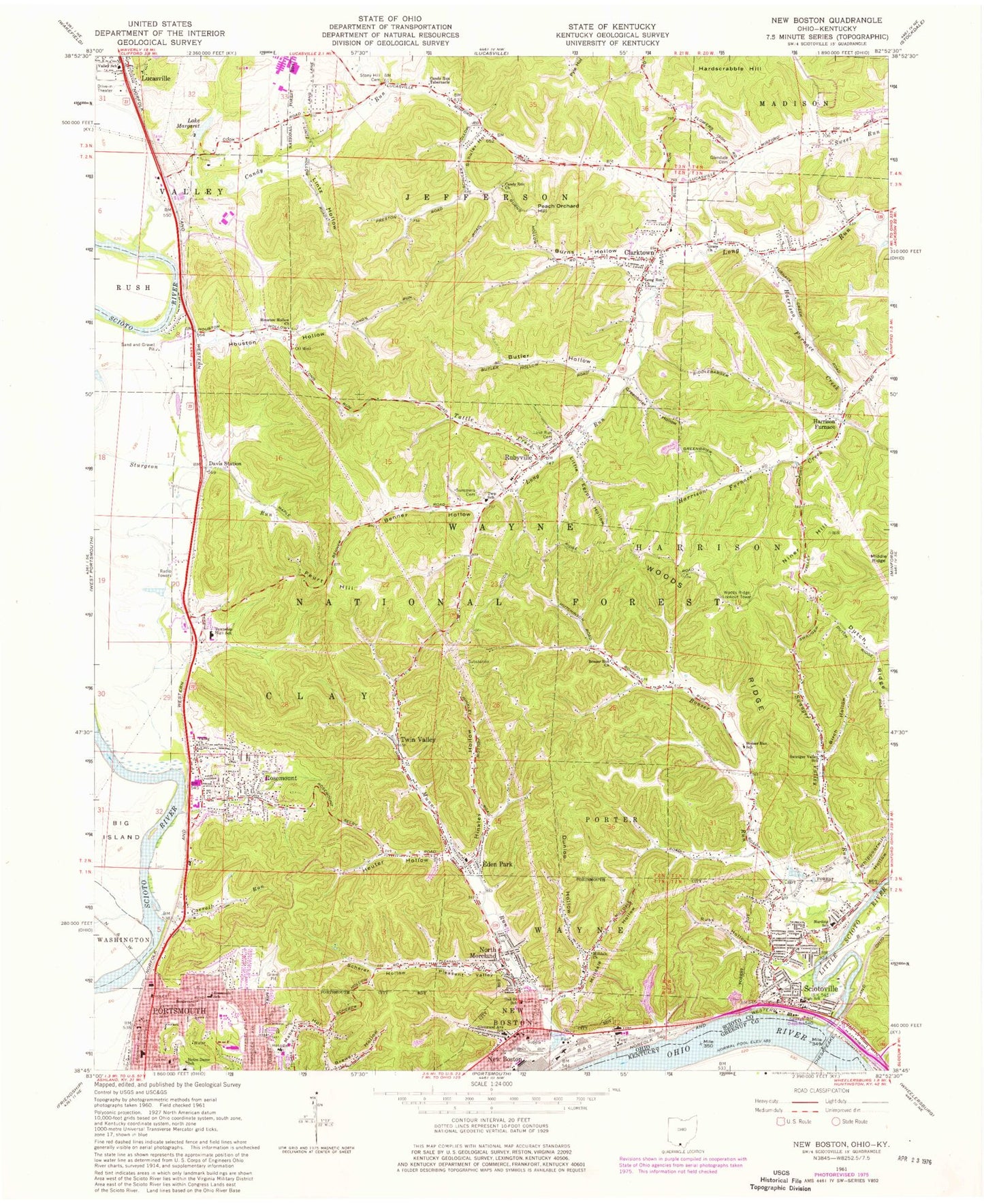
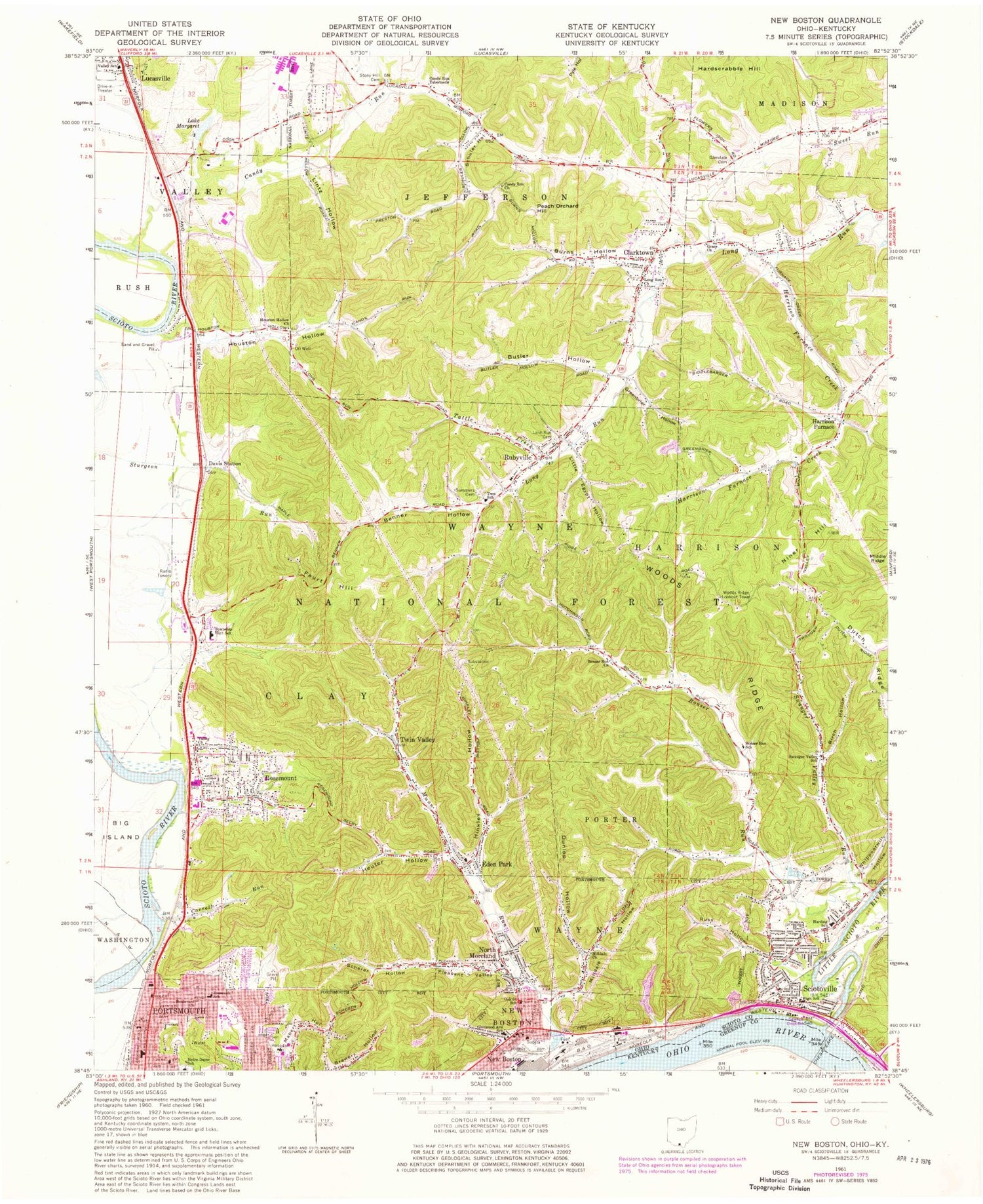
Classic USGS New Boston Ohio 7.5'x7.5' Topo Map
Couldn't load pickup availability
Historical USGS topographic quad map of New Boston in the state of Ohio. Typical map scale is 1:24,000, but may vary for certain years, if available. Print size: 24" x 27"
This quadrangle is in the following counties: Greenup, Scioto.
The map contains contour lines, roads, rivers, towns, and lakes. Printed on high-quality waterproof paper with UV fade-resistant inks, and shipped rolled.
Contains the following named places: Benner Hollow, Birch Hollow, Bonser Run Church, Bonser Run School, Boulevard Church, Burns Hollow, Butler Hollow, Candy Run Church, Candy Run Tabernacle, Carroll Run, Clarktown, Dunlop Hollow, Glendale Cemetery, Greenbrier Hollow, Harrison Furnace Creek, Heuter Hollow, Hinkley Hollow, Houston Hollow, Houston Hollow Church, Lintz Hollow, Long Run Cemetery, Middle Ridge, Milldale Church, Milldale Hollow, North Moreland, Notre Dame School, Pleasant Valley, Rubyville, Russ Hollow, Scherer Hollow, Schuler Hollow, Stony Hill Cemetery, Summers Cemetery, Swauger Valley School, Tattle Creek, Twin Valley, Valley Church, Woods Ridge, Little Scioto Bar, Portsmouth East High School, Portsmouth East Middle School, Harrison Furnace School (historical), Glendale Elementary School, Munn School (historical), Flatwoods School (historical), Rubyville Elementary School, Sheer School (historical), North Moreland School, Turkey Hollow, Sheets Hollow, Coon Hollow, Scioto County Vocational Technical School, Fort Hollow, Johnson Hollow, Water Hollow, Peachorchard Hollow, Pond Hollow, Rosemont Hollow, Clay High School, Noel School (historical), Rosemount Elementary School, Portsmouth Mental Receiving Hospital, Southern Ohio Medical Center, Briggs School (historical), Eden Park, Feurt Hill, Hardscrabble Hill, New Boston, Rosemount, Oak Street School, Valley School, Harrison Furnace, Rubyville Community Church, Twin Valley Baptist Church, Rosemount Nazarene Church, Central Presbyterian Church, Portsmouth Seventh Day Adventist Church, Manly United Methodist Church, Christ Community Church, First Church of God, New Boston First Church of the Nazarene, New Boston United Methodist Church, Immanuel Baptist Church, Saint Monica Catholic Church, Sciotoville Church of the Nazarene, Church of Christ, Berean Baptist Church, Sciotoville Christian Church, Sciotoville United Methodist Church, Grace Church, Long Run Church, Sciotoville, Vera Junction, Swauger Valley Run, Bonser Run, Candy Run, Munn Run, Niner Hill, Pond Creek, East Portsmouth (historical), Horner Hollow, Davis Station, Scioto County, Dutch Ridge, Little Scioto River, Whippoorwill Hollow, New Boston Stadium, New Boston Branch LIbrary, Lake Margaret Dam, Lake Margaret, Woods Ridge Lookout Tower, Glenwood High School, Harding Elementary School, Roosevelt Elementary School, WNXT-AM (Portsmouth), Township of Clay, Village of New Boston, City of Portsmouth, Candy Run Baptist Cemetery, Harrison Furnace Cemetery, New Boston Post Office (historical), Sciotoville Post Office (historical), Middle Ridge, Rosemount Census Designated Place, Rivers of Joy Baptist Church, Southern Ohio Medical Center Inpatient Rehabilitation Center, Southern Ohio Correctional Facility Fire Department, Portsmouth Fire Department Sciotoville Fire Station, Jefferson Township Volunteer Fire Department, Rosemount Volunteer Fire Department, Rubyville Volunteer Fire Department and Clay Squad 11, New Boston Fire Department, Scioto Ambulance District Squad 12, Scioto Ambulance District Squad 11, Colony Mobile Home Park, Modern Mobile Home Park, Portsmouth Mobile Home Park, Clarktown Census Designated Place, New Boston Police Department, Ohio State Highway Patrol - Portsmouth Patrol Post, Sciotoville Post Office, Little Egypt Hollow, Trade Valley Hollow