MyTopo
Classic USGS New Haven Michigan 7.5'x7.5' Topo Map
Couldn't load pickup availability
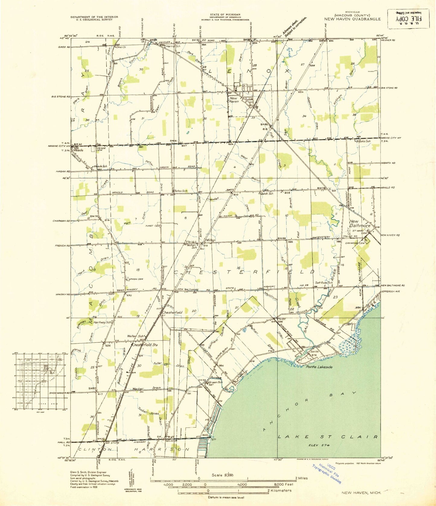
Historical USGS topographic quad map of New Haven in the state of Michigan. Map scale may vary for some years, but is generally around 1:24,000. Print size is approximately 24" x 27"
This quadrangle is in the following counties: Macomb.
The map contains contour lines, roads, rivers, towns, and lakes. Printed on high-quality waterproof paper with UV fade-resistant inks, and shipped rolled.
Contains the following named places: Anchor Bay Adult Education School, Anchor Bay Gardens, Anchor Bay Harbor, Anchor Bay Middle School South, Anchor Bay Shores, Anna Mae Burdi Center for Community Development, Auvase Creek, Bark Drain, Bethlehem Temple Church, Bowman Ditch, Brandenburg Drain, Centennial Cemetery, Chesterfield, Chesterfield Crossing Shopping Center, Chesterfield Post Office, Chesterfield School, Chesterfield Shores, Chesterfield Station, Chesterfield Township Fire Department Station 1, Chesterfield Township Fire Department Station 2, Chesterfield Township Fire Department Station 3, Chesterfield Township Police Department, Chestertown Center Shopping Center, Chouteau Chesterfield Mobile Home Park, Christian Life Church, Church of the Covenant, Compass Point School, Crandall Drain, Dean A Naldrett School, East Branch Fish Creek, Fairchild Chapel, First Congregational Church, Fish Creek, Francis A Higgins Elementary School, Fuller Drain, Gibbons Drain, Goulette Point, Green School, Haire Cemetery, Harbor Oaks Hospital, Harms Drain, Hart Cemetery, Joseph M Carkenord Elementary School, Kirkham Drain, Kolping Chapel Historical Marker, Kolping Park, Lake Tranquillity, L'Anse Creuse High School North, L'Anse Creuse Middle School East, L'Anse Creuse Middle School North, Lemmon School, Lenox Gas Storage Field, Lenox Township Fire Department Station 1 Headquarters, Lenox Township Library, Lottie Schmidt Elementary School, Lottivue, Macomb Church, Macomb Correctional Facility, Macomb Correctional Facility School, Maple Grove Church, Meade, Meade Cemetery, Meade Church, Meade Post Office, Meldrum Drain, Merritt Academy, Milton, Milton Post Office, Naldrett School, New Baltimore Post Office, New Haven, New Haven Elementary School, New Haven Fire Department, New Haven High School, New Haven Medical Center, New Haven Middle School, New Haven Post Office, New Haven Seventh Day Adventist Church, New Haven Station, New Haven Village Fire Department, North Gratiot Crossing Shopping Center, Oak Ridge Golf Course, Oakwood Cemetery, Omo Post Office, Parker Drain, Peltier Drain, Pitts Drain, Plaza at the Pointe Shopping Center, Point Lakeview, Ray-Lenox Drain, Richmond - Lenox Emergency Medical Services Ambulance Station 3, Riverbrook Mobile Home Park, Saint Francis Church, Saint John School, Saint Mary's Cemetery, Saint Peters Church, Salt River, Salt River Golf Course, Sebille Manor, Selfridge Field Historical Marker, Shook Drain, Siefert School, Stark Drain, Sugarbush Elementary School, Sutherland oemig Drain, Township of Chesterfield, Tucker Jones Drain, Union Cemetery, Village of New Haven, Wacker Drain, Warwick Drain, West Branch Fish Creek, ZIP Codes: 48047, 48048, 48051