
MyTopo
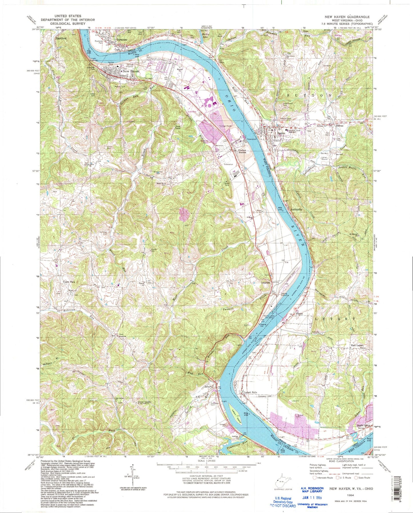
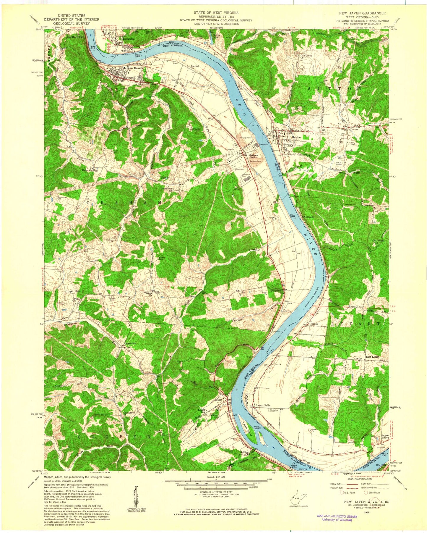
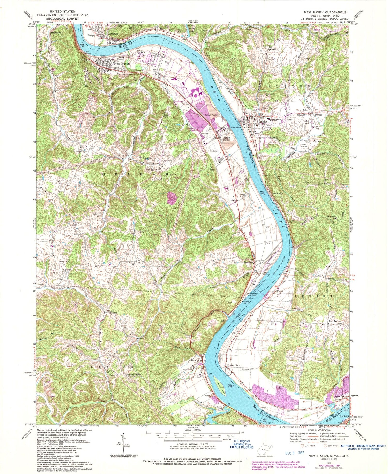
Classic USGS New Haven West Virginia 7.5'x7.5' Topo Map
Couldn't load pickup availability
Historical USGS topographic quad map of New Haven in the states of West Virginia, Ohio. Typical map scale is 1:24,000, but may vary for certain years, if available. Print size: 24" x 27"
This quadrangle is in the following counties: Jackson, Mason, Meigs.
The map contains contour lines, roads, rivers, towns, and lakes. Printed on high-quality waterproof paper with UV fade-resistant inks, and shipped rolled.
Contains the following named places: Board Church, Brinker Run, Broad Run, Broad Run Cemetery, Broad Run School (historical), Claylick Run, Evergreen Cemetery, Graham Church, Graham Station, Guiding Church, Hoffman Cemetery, Letart, Letart Island, Little Broad Run, Mud Run, Oak Grove Church, Quillen Park, Racine Locks and Dam, Seaman Run, Spring Run, Tombleson Run, Twomile Creek, Union Cemetery, Union Church, Vernon Church, West Creek, White Church, Cedar Hill Cemetery, Zion Church, Longdale, General Assembly of the Lord Church, New Haven, Upper Flats, Racine Locks and Dam, Avalanche School (historical), Board, Broad Creek School (historical), Elroy Kaylor Spring, Elroy Kaylor Spring, Letart Post Office, Little Forest School (historical), Lock Number 24 (historical), New Haven Elementary School, New Haven Post Office, Oakgrove School (historical), Okey Roush Spring, Rayford Roush Spring, Longdale Cemetery, Upper Flats - White Church Cemetery, Wolf Bar, Graham District, Town of Hartford City, Town of New Haven, Sycamore Hollow School, New Haven and Community Volunteer Fire Department, Peter Fry Cemetery, Graham Cemetery, Oak Grove Cemetery, New Haven Public Library, New Haven Police Department, Welsh Cemetery, Bailey Lake, Cabin Creek, East Letart, Greenwood Cemetery, Jennie Watts Run, Johns Run, Southern Local High School, Sanfords Landing, Alexanders Landing, Peytons Landing, Mount Moriah School (historical), Peytons Run, Southern Elementary School, Oakgrove (historical), Lock and Dam Number 24 (historical), Jessie Creek, Syracuse, Peyton Landing, Widow Parr Landing, Plants, German Fork, Antiquity, Dorcas, Letart Falls, Bethany Church, Bowman Run, Racine, Wolf Run, Yellowbush Creek, Carleton Creek, Letart Falls Elementary School, Weaver Bar, Forked Run, Racine Elementary School, Syracuse Elementary School, Letart Falls Cemetery, Letart Falls United Brethren in Christ Church, Letart Falls United Methodist Church, Letart Falls Bottoms, Cedar Hill, East Letart School (historical), East Letart United Methodist Church, Plants Cemetery, Plants Methodist Church, Condeville, Condeville Methodist Church, Oak Grove School (historical), Oak Grove Methodist Church, Oak Grove Cemetery, Steve Finlaw Lake Dam, Steve Finlaw Lake, Letart Falls Post Office (historical), Tuppers Run, Township of Letart, Antiquity Post Office (historical), Dorcas Post Office (historical), Plants Post Office (historical), Syracuse Post Office, Racine Post Office, Village of Racine, Village of Syracuse, Racine Volunteer Fire Department, Syracuse Volunteer Fire Department, Racine Emergency Medical Services, Never Dunn Farm and Greenhouses, Rowe Farm, Board Church, Brinker Run, Broad Run, Broad Run Cemetery, Broad Run School (historical), Claylick Run, Evergreen Cemetery, Graham Church, Graham Station, Guiding Church, Hoffman Cemetery, Letart, Letart Island, Little Broad Run, Mud Run, Oak Grove Church, Quillen Park, Racine Locks and Dam, Seaman Run, Spring Run, Tombleson Run, Twomile Creek, Union Cemetery, Union Church, Vernon Church, West Creek, White Church, Cedar Hill Cemetery, Zion Church, Longdale, General Assembly of the Lord Church, New Haven, Upper Flats, Racine Locks and Dam, Avalanche School (historical), Board, Broad Creek School (historical), Elroy Kaylor Spring, Elroy Kaylor Spring, Letart Post Office, Little Forest School (historical), Lock Number 24 (historical), New Haven Elementary School, New Haven Post Office, Oakgrove School (historical), Okey Roush Spring, Rayford Roush Spring, Longdale Cemetery, Upper Flats - White Church Cemetery, Wolf Bar, Graham District, Town of Hartford City, Town of New Haven, Sycamore Hollow School, New Haven and Community Volunteer Fire Department, Peter Fry Cemetery, Graham Cemetery, Oak Grove Cemetery, New Haven Public Library, New Haven Police Department, Welsh Cemetery, Bailey Lake, Cabin Creek, East Letart, Greenwood Cemetery, Jennie Watts Run, Johns Run, Southern Local High School, Sanfords Landing, Alexanders Landing, Peytons Landing, Mount Moriah School (historical), Peytons Run, Southern Elementary School, Oakgrove (historical), Lock and Dam Number 24 (historical), Jessie Creek, Syracuse, Peyton Landing, Widow Parr Landing, Plants, German Fork, Antiquity, Dorcas, Letart Falls, Bethany Church, Bowman Run, Racine, Wolf Run, Yellowbush Creek, Carleton Creek, Letart Falls Elementary School, Weaver Bar, Forked Run, Racine Elementary School, Syracuse Elementary School, Letart Falls Cemetery, Letart Falls United Brethren in Christ Church, Letart Falls United Methodist Church, Letart Falls Bottoms, Cedar Hill, East Letart School (historical), East Letart United Methodist Church, Plants Cemetery, Plants Methodist Church, Condeville, Condeville Methodist Church, Oak Grove School (historical), Oak Grove Methodist Church