
MyTopo
Classic USGS New Matamoras Ohio 7.5'x7.5' Topo Map
Couldn't load pickup availability
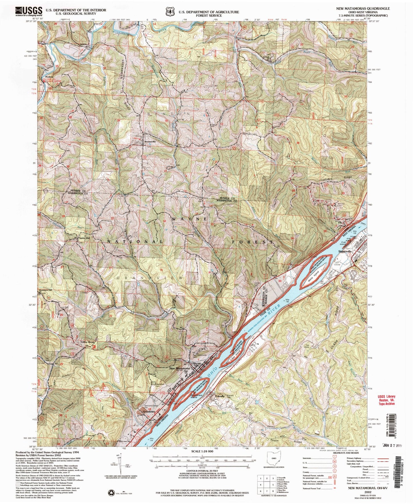
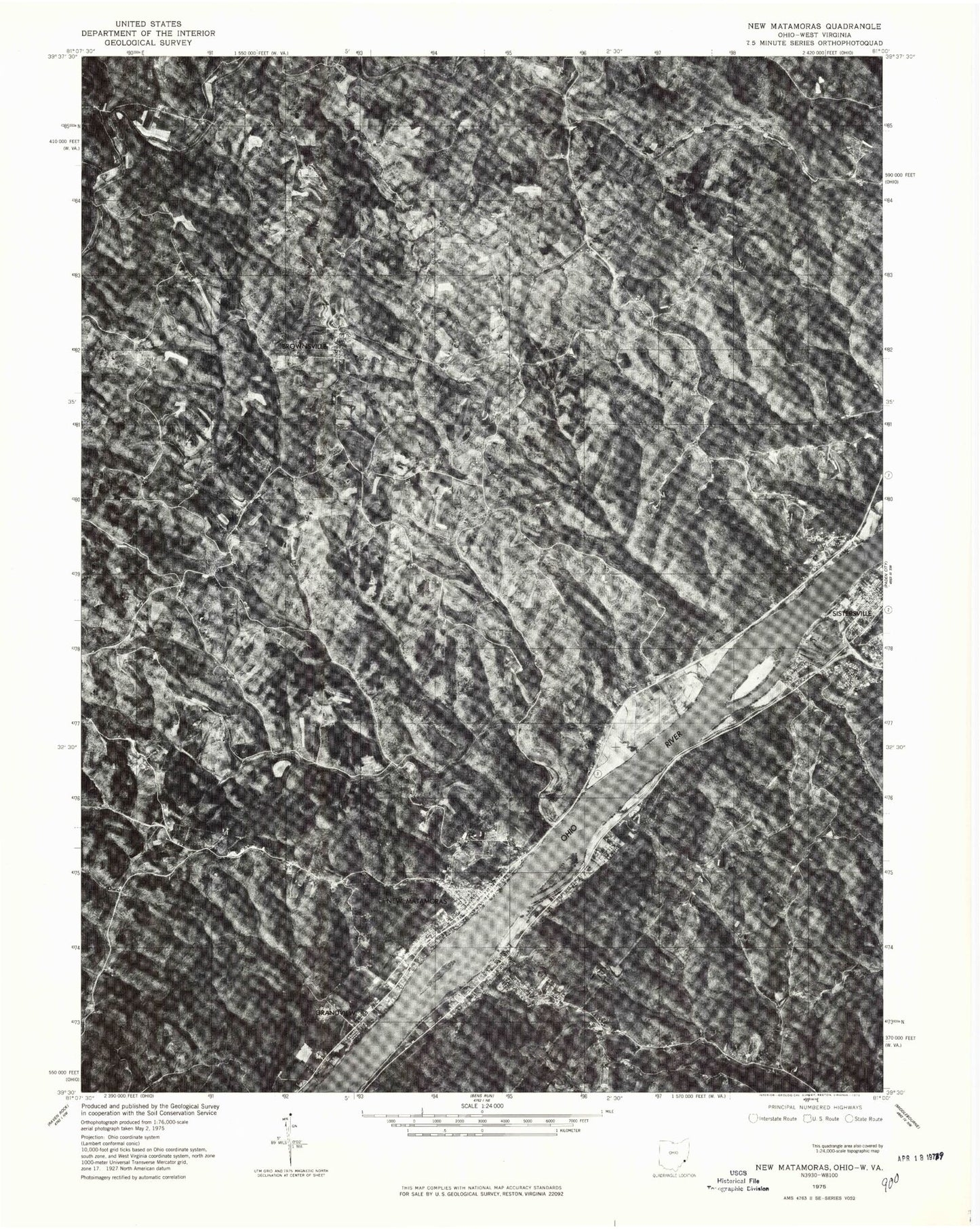
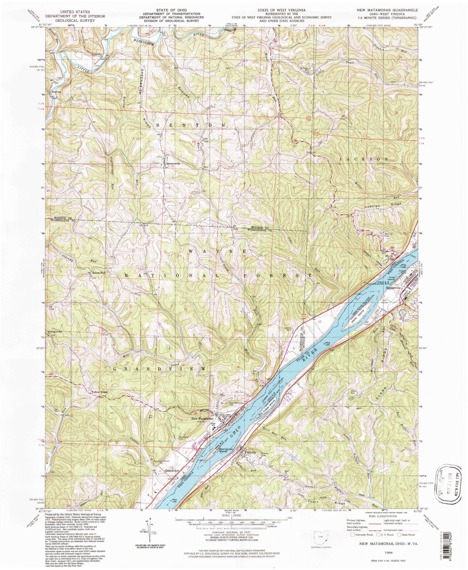
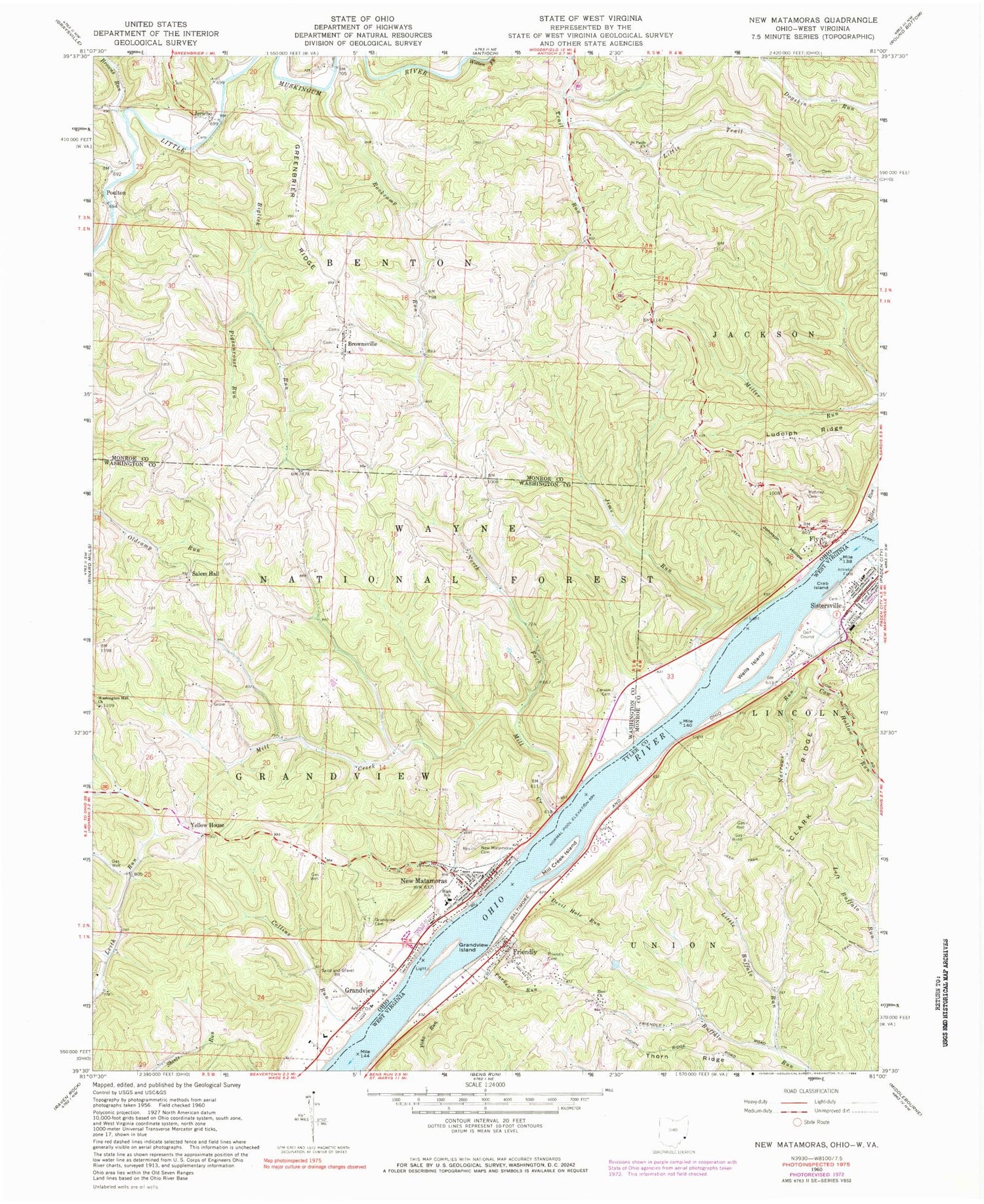
Historical USGS topographic quad map of New Matamoras in the states of Ohio, West Virginia. Typical map scale is 1:24,000, but may vary for certain years, if available. Print size: 24" x 27"
This quadrangle is in the following counties: Monroe, Tyler, Washington.
The map contains contour lines, roads, rivers, towns, and lakes. Printed on high-quality waterproof paper with UV fade-resistant inks, and shipped rolled.
Contains the following named places: Grandview Run, Matamoras Elementary School, Mill Creek Landing, Trail Run (historical), Bradfield Landing, Stringtown (historical), Fly Ferry, Rockcamp Run, Centerview (historical), Wahanaker, Frontier High School, Biglick Run, Browns Run, Brownsville, Collins Run, Fly, Grandview, Grandview Cemetery, Greenbrier Ridge, Jericho, Jims Run, Johnson Hollow, Little Trail Run, Mehrley Cemetery, Mill Creek, Miller Run, North Fork Mill Creek, Pigeonroost Run, Poulton, Saint Pauls United Church of Christ, Salem Hall, Washington Hall Church, Witten Fork, Yellow House, Rockcamp Run, New Matamoras Cemetery, Ludolph Ridge, New Matamoras, City of Matamoras, Township of Benton, Township of Jackson, Township of Grandview, Brownsville Methodist Cemetery, Brownsville Methodist Church, Jericho Methodist Cemetery, Jericho Methodist Church, Rings Mill Cemetery, Saint Pauls Evangelical Cemetery, Carson Cemetery, Salem Hall Cemetery, Springer Grave, Fly Post Office, Poulton Post Office (historical), Brownsville United Presbyterian Cemetery, German Lutheran Cemetery, Hensel Cemetery, Village of Matamoras, Grandview Township Volunteer Fire Department, New Matamoras Emergency Medical Services, New Matamoras Post Office, Clark Ridge, Cow Hollow Run, Crab Island, Devil Hole Run, Friendly Cemetery, Grandview Island, Little Buffalo Run, Mill Creek Island, Narrows Run, Parker Run, Tanyard Run, Thorn Ridge, Wells Island, Yoho Run, Zion Church, Friendly, Excelsior School (historical), First Christian Church, Friendly Post Office, Sistersville General Hospital, Sistersville High School (historical), Sistersville Junior High School (historical), Central District, Town of Friendly, Sistersville Volunteer Fire Department, Sistersville General Hospital Ambulance Service, Sistersville Country Club Golf Course, Grandview Run, Matamoras Elementary School, Mill Creek Landing, Trail Run (historical), Bradfield Landing, Stringtown (historical), Fly Ferry, Rockcamp Run, Centerview (historical), Wahanaker, Frontier High School, Biglick Run, Browns Run, Brownsville, Collins Run, Fly, Grandview, Grandview Cemetery, Greenbrier Ridge, Jericho, Jims Run, Johnson Hollow, Little Trail Run, Mehrley Cemetery, Mill Creek, Miller Run, North Fork Mill Creek, Pigeonroost Run, Poulton, Saint Pauls United Church of Christ, Salem Hall, Washington Hall Church, Witten Fork, Yellow House, Rockcamp Run, New Matamoras Cemetery, Ludolph Ridge, New Matamoras, City of Matamoras, Township of Benton, Township of Jackson, Township of Grandview, Brownsville Methodist Cemetery, Brownsville Methodist Church, Jericho Methodist Cemetery, Jericho Methodist Church, Rings Mill Cemetery, Saint Pauls Evangelical Cemetery, Carson Cemetery, Salem Hall Cemetery, Springer Grave, Fly Post Office, Poulton Post Office (historical), Brownsville United Presbyterian Cemetery, German Lutheran Cemetery, Hensel Cemetery, Village of Matamoras, Grandview Township Volunteer Fire Department, New Matamoras Emergency Medical Services, New Matamoras Post Office, Clark Ridge, Cow Hollow Run, Crab Island, Devil Hole Run, Friendly Cemetery, Grandview Island, Little Buffalo Run, Mill Creek Island, Narrows Run, Parker Run, Tanyard Run, Thorn Ridge, Wells Island, Yoho Run, Zion Church, Friendly, Excelsior School (historical), First Christian Church, Friendly Post Office, Sistersville General Hospital, Sistersville High School (historical), Sistersville Junior High School (historical), Central District, Town of Friendly, Sistersville Volunteer Fire Department, Sistersville General Hospital Ambulance Service, Sistersville Country Club Golf Course, Grandview Run, Matamoras Elementary School, Mill Creek Landing, Trail Run (historical), Bradfield Landing, Stringtown (historical), Fly Ferry, Rockcamp Run, Centerview (historical), Wahanaker, Frontier High School, Biglick Run, Browns Run, Brownsville, Collins Run, Fly, Grandview, Grandview Cemetery, Greenbrier Ridge, Jericho, Jims Run, Johnson Hollow, Little Trail Run, Mehrley Cemetery, Mill Creek, Miller Run, North Fork Mill Creek, Pigeonroost Run, Poulton, Saint Pauls United Church of Christ, Salem Hall, Washington Hall Church, Witten Fork, Yellow House, Rockcamp Run, New Matamoras Cemetery, Ludolph Ridge, New Matamoras, City of Matamoras, Township of Benton, Township of Jackson, Township of Grandview, Brownsville Methodist Cemetery, Brownsville Methodist Church, Jericho Methodist Cemetery, Jericho Methodist Church, Rings Mill Cemetery, Saint Pauls Evangelical Cemetery, Carson Cemetery, Salem Hall Cemetery, Springer Grave, Fly Post Office, Poulton Post Office (historical), Brownsville United Presbyterian Cemetery, German Lutheran Cemetery, Hensel Cemetery, Village of Matamoras, Grandview Township Volunteer Fire Department, New Matamoras Emergency Medical Services, New Matamoras Post Office, Clark Ridge, Cow Hollow Run