MyTopo
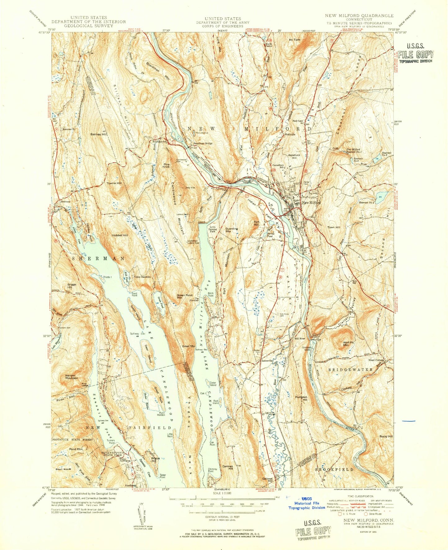
Classic USGS New Milford Connecticut 7.5'x7.5' Topo Map
Couldn't load pickup availability
Historical USGS topographic quad map of New Milford in the state of Connecticut. Typical map scale is 1:24,000, but may vary for certain years, if available. Print size: 24" x 27"
This quadrangle is in the following counties: Fairfield, Litchfield.
The map contains contour lines, roads, rivers, towns, and lakes. Printed on high-quality waterproof paper with UV fade-resistant inks, and shipped rolled.
Contains the following named places: Allens Cove, Aspetuck Hill, Barnes Hill, Birch Groves, Birch Point, Boardman Bridge, Boardman Mountain, Boardman School, Bogus Hill, Briggs Hill, Bullymuck Brook, Camp Allen, Camp Ludington, Camp Mauwehu, Candlewood Mountain, Candlewood Trail, Candlewood Trails, Lake Candlewood, Canterbury School, Carmen Hill, Cedar Island, Chimney Point, Clapboard Oak Brook, Clatter Valley, Coburn Cemetery, Cross Brook, Deer Island, East Aspetuck River, Ferris Pond, Fort Hill, Fort Mountain, Gallows Hill, Glen Brook, Goodyear Island, Great Brook, Great Mountain, Great Neck, Green Island, Green Pond, Green Pond Mountain, Guarding Mountain, Haviland Millpond, Hitchcock Mill Brook, Holiday Point, Holy Cross Cemetery, Housatonic Valley, Hubbell Hill, Indian Field, Kelly Slide, Lanesville, Little Brook, Little Neck, Lookout Point, Lovers Leap, Lynn Deming Park, Lake Mauweehoo, Mead Corners, Merryall Brook, New Milford, New Milford Bay, New Milford High School, Oak Island, Oak Point, Pine Knob, Pine Ledge, Point Hedden, Pond Mountain, Pond Point, Pootatuck State Forest, Pumpkin Hill, Quaker Cemetery, Quipy Swamp, Rock Island, Rocky Hill, Rocky River, Sawmill Brook, Shelter Harbor, Sherman Church, Short Woods, Spear Point, Squantz Cove, Squantz Pond, Squantz Pond State Park, Still River, Still River, Stillson Hill, The Lime Kiln, The Narrows, Thistle Island, Tollgate Brook, Mount Tom, Town Farm Brook, Town Hill, Towner Hill, Turners Point, Vaughns Neck, Wannuppee Islands, Wanzer Mountain, West Aspetuck River, Wolf Pit Mountain, Worden Brook, Candlewood Point, Candlewood Springs, Hurds Corner, Sherman, Wellsville, Candlewood Lookout Tower, New Milford Reservoir Number 1, Reservoir Number 2, Reservoir Number 3, Reservoir Number 4, Docktors Field (historical), Candlelight Farms Airport, Candlelight Heliport, Town of New Milford, Town of Sherman, Lake Candlewood Dam, New Milford Reservoir Number 4 Dam, New Milford Reservoir Number 3 Dam, Bleachery Dam, Housatonic River Reservoir, Lake Mauweehoo Dam, Day Pond Dam, Day Pond, Haviland Millpond Dam, New Milford Reservoir Number 2 Dam, Green Pond Dam, Ladner Pond Dam, Ladner Pond, Lake Candlewood Dike Number 2, Addis Park, Aspetuck Plain (historical), Baldwin Park, Boardmans Bridge, Candlewood Point, Candlewood Valley Country Club, Clatter Valley Park, Finest Super Center Shopping Center, Gallows Hill Burying Ground, Great Mountain Pond, Hill and Plain School, John Pettibone Elementary School, Lores Plaza Shopping Center, Lovers Leap Bridge, Lovers Leap State Park, Maplewood Industrial Park, New Milford Center Historic District, New Milford Historical Society Museum, New Milford Hospital, New Milford Hospital Health Sciences Library, New Milford Post Office, New Milford Public Library, New Milford Shopping Plaza Shopping Center, New Milford Town Hall, Northville Elementary School, Atchison Cove, Colonial Park, Joyceland (historical), Lakeside Woods, Sherman North Cemetery, Sherman Center Cemetery, Sherman Library, Sherman Post Office, Sherman School, Sherman Town Park, Chimney Point, Park Lane, New Milford Census Designated Place, Water Witch Hose Company 1 Lanesville Station, New Milford Volunteer Fire Department, Water Witch Hose Company 2 Grove Station, New Milford Fire Marshal's Office, Sherman Fire Marshal's Office, Squantz Engine Company, Sherman Volunteer Fire Department, New Milford Community Ambulance, New Milford Police Department, Center Cemetery, Saint Francis Xavier Cemetery, Bogus Hill Census Designated Place, Bogus Hill, Inglenook Census Designated Place, Inglenook, Knollcrest Census Designated Place, Lakeside Woods Census Designated Place, Sail Harbor Census Designated Place, Sail Harbor, Sherman Census Designated Place, Chimney Point Census Designated Place, Chimney Point