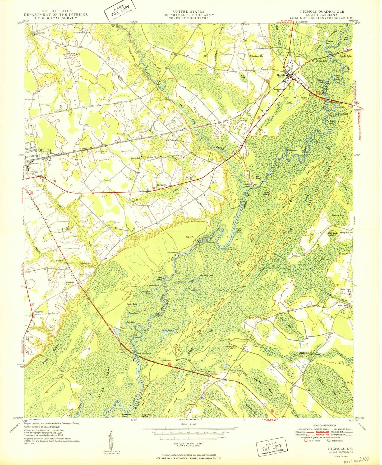
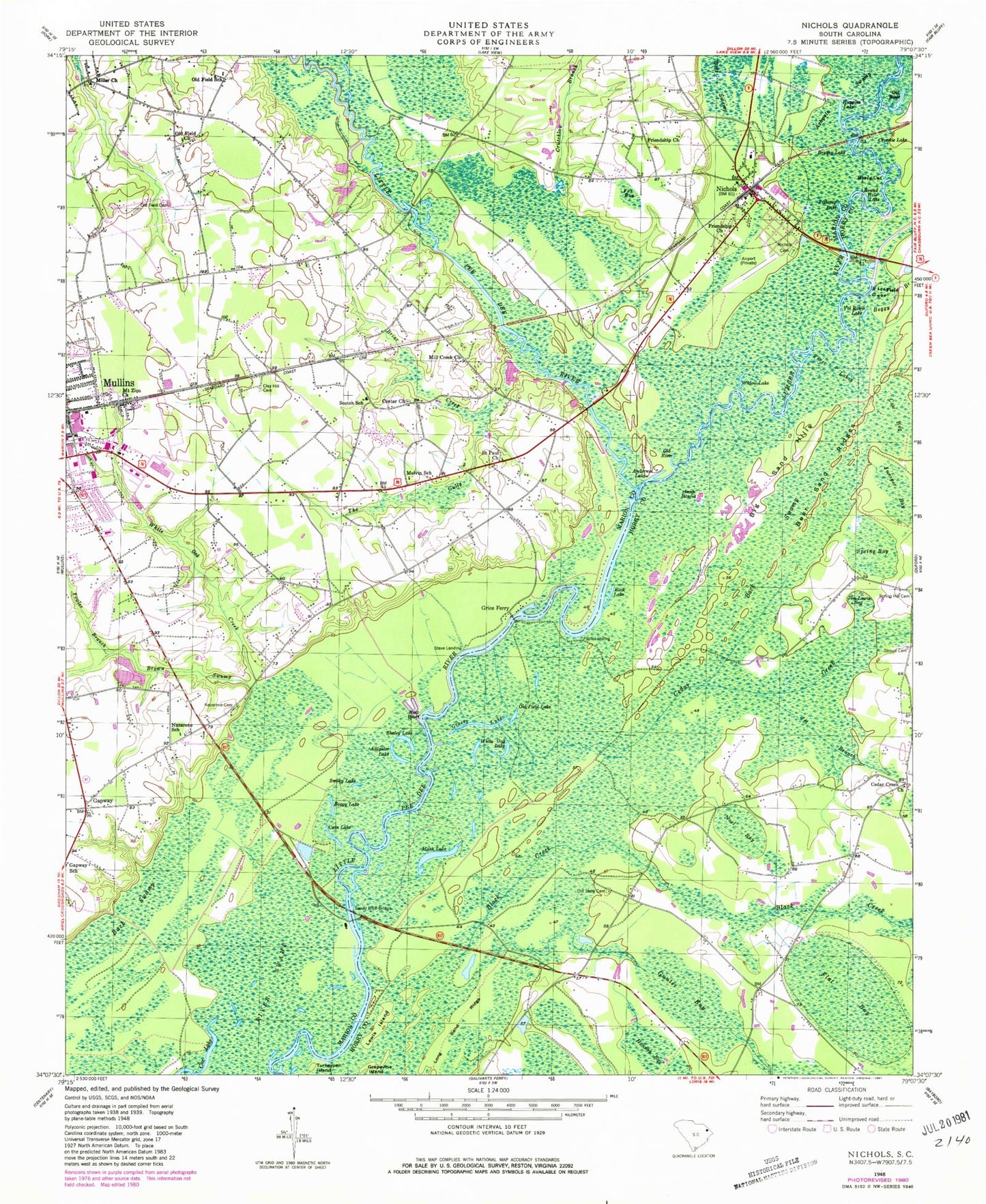
MyTopo
Classic USGS Nichols South Carolina 7.5'x7.5' Topo Map
Couldn't load pickup availability
Historical USGS topographic quad map of Nichols in the state of South Carolina. Map scale may vary for some years, but is generally around 1:24,000. Print size is approximately 24" x 27"
This quadrangle is in the following counties: Horry, Marion.
The map contains contour lines, roads, rivers, towns, and lakes. Printed on high-quality waterproof paper with UV fade-resistant inks, and shipped rolled.
Contains the following named places: Alligator Lake, Anderson Lake, Atkinson Farm, Back Swamp, Bear Sand Ridges, Big Sand Hills, Black Creek, Boggy Branch, Boggy Lake, Briar Creek, Brown Swamp, Brushy Lake, Cain Lake, Cedar Creek, Cedar Creek Church, Cedar Creek School, Center Church, Church of God, Clay Hill Cemetery, Cow Bog, Cox Lake, Crosstie Lake, Crutchlow Branch, First Friendship Baptist Church, Fishtrap Lake, Flat Bay, Floyds Ferry, Fowler Branch, Fox Bay, Friendship Church, Gapway, Gapway Baptist Church, Grapevine Island, Grassy Lake, Grice Ferry, Grices Ferry, Gunter Bay, Hannah Bay, Hawk Island, Huggins Lake, Jesus Christ Church, Jet Branch, Jim Lewis Bay, Juniper Bay, Lewis Island, Long Sand Ridge, Lumber River, Mash Lake, McCormick Elementary School, McMillen Lower Pond Dam D-0515, McMillen Upper Pond Dam D-0514, Melvin School, Mill Creek Church, Miller Church, Mount Zion Church, Mullins Church of God, Mullins Division, Mullins Wastewater Treatment Plant, Nazarene Cemetery, Nazarene Church, Nazarene School, New Born Assembly Church, Newsons Ferry, Nichols, Nichols Bridge, Nichols Cemetery, Nichols Elementary School, Nichols Library, Nichols Police Department, Nichols Post Office, Nichols United Methodist Church, Nichols Volunteer Fire Department, Noel Bay, Old Field Cemetery, Old Field Church, Old Field Lake, Old Field School, Old River, Old State Cemetery, Pineland Country Club, Pitch Lake, Pitch Landing, Rech Lake, Red Bluff, Rice Field Cove, River Swamp, Round Hole Lake, Saint Paul Baptist Church, Saint Paul Church, Sandy Bluff Bridge, Scotch School, Shaley Lake, Smoky Lake, Spring Bay, Stave Landing, Stroud Cemetery, Stroud Pond, Stroud Pond Dam D-3612, The Gully, Three Lakes, Town of Nichols, Turkeypen Island, Vol Rowll Lake, White Oak Creek, White Oak Lake, Widow Lake, Williams Chapel African Methodist Episcopal Church, Woodlawn Park Baptist Church, Worly Cut