MyTopo
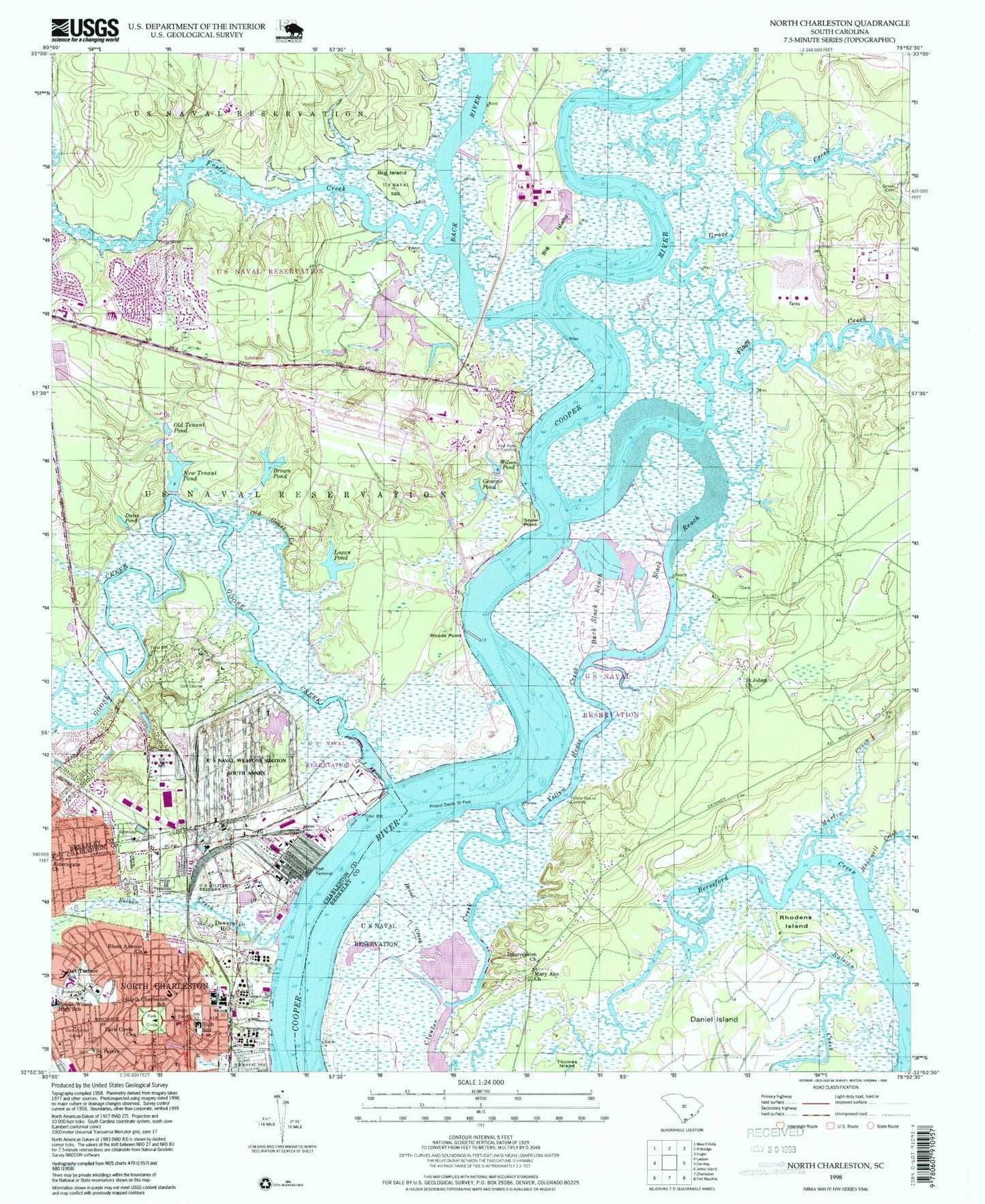
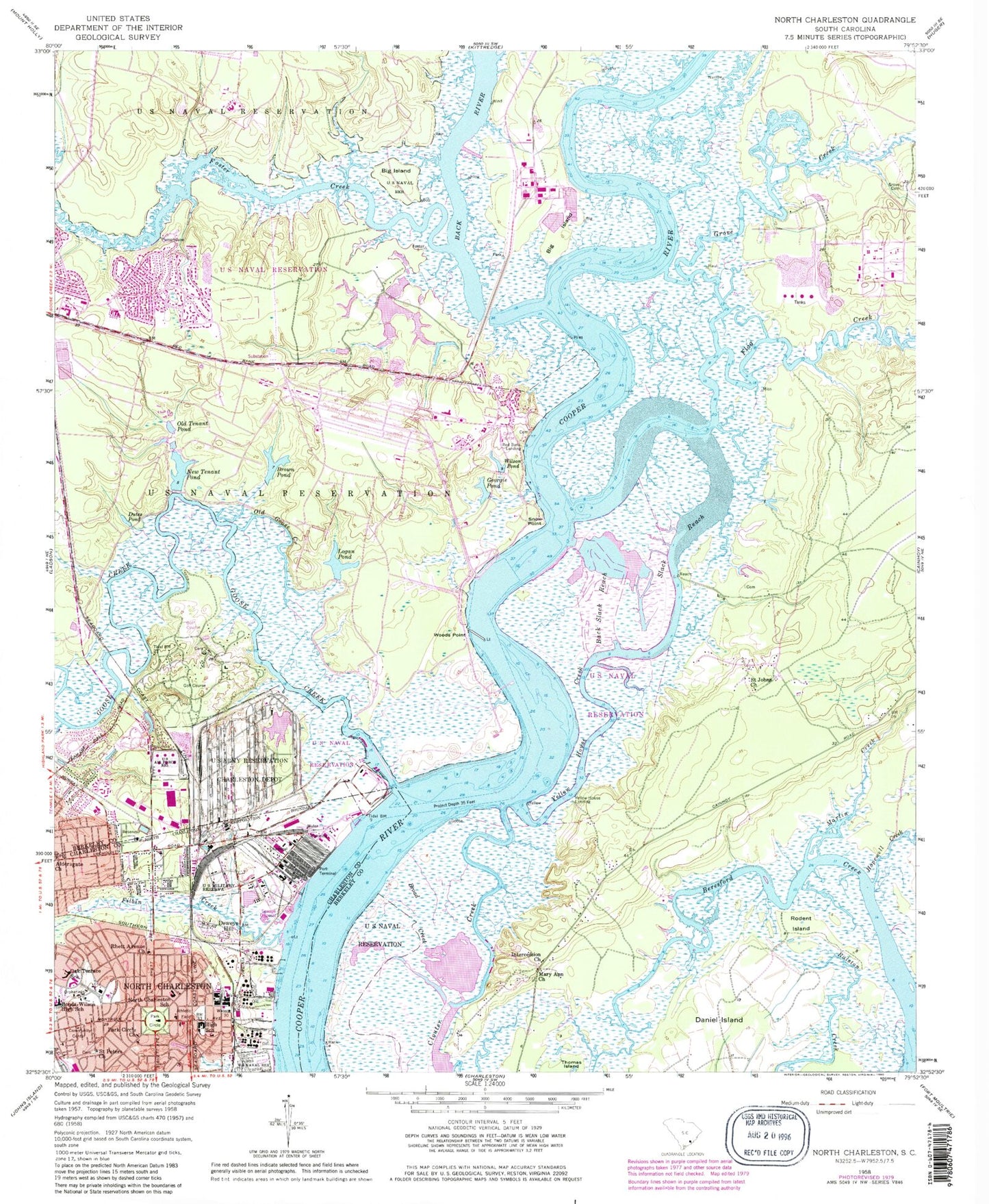
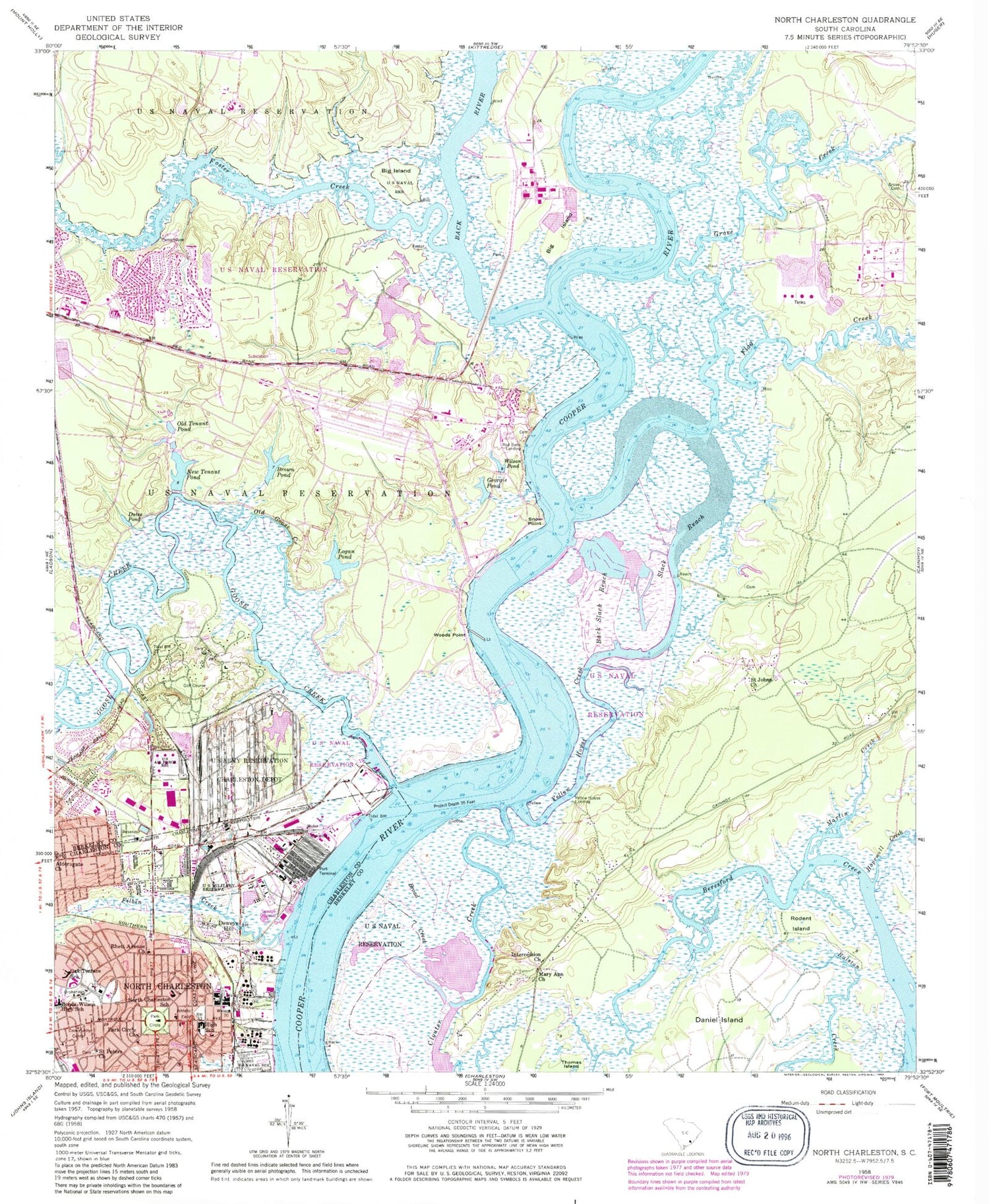
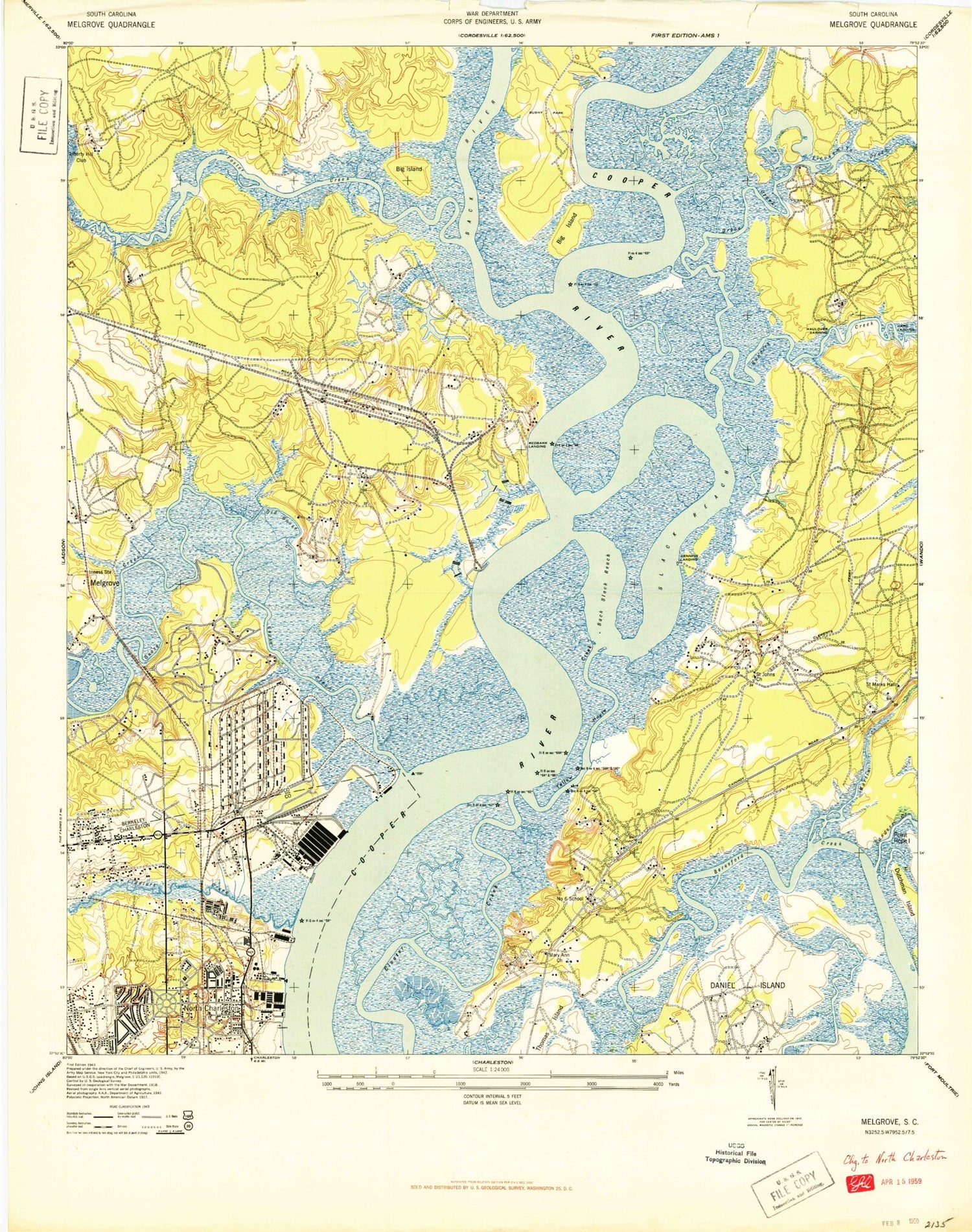
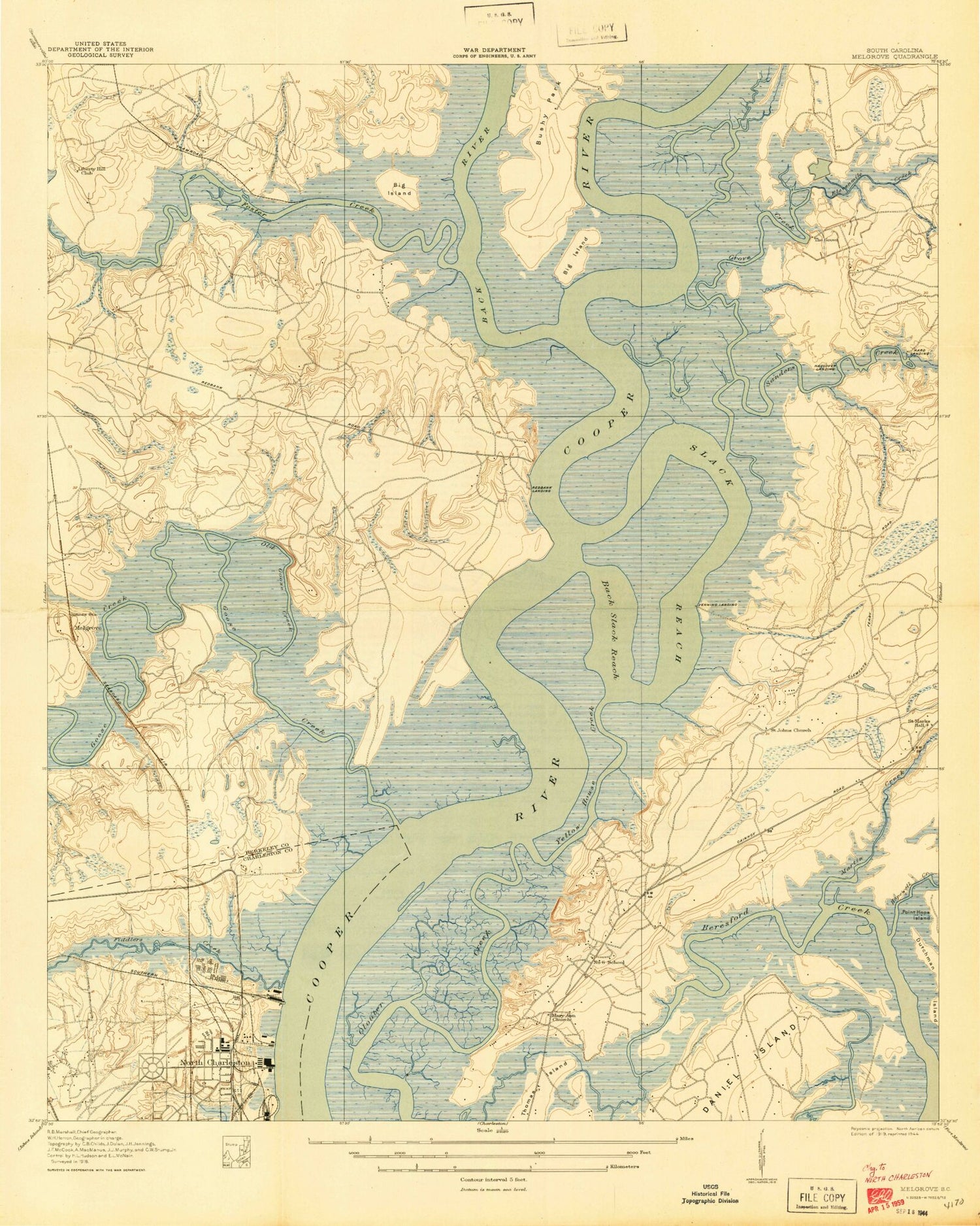
Classic USGS North Charleston South Carolina 7.5'x7.5' Topo Map
Couldn't load pickup availability
Historical USGS topographic quad map of North Charleston in the state of South Carolina. Typical map scale is 1:24,000, but may vary for certain years, if available. Print size: 24" x 27"
This quadrangle is in the following counties: Berkeley, Charleston.
The map contains contour lines, roads, rivers, towns, and lakes. Printed on high-quality waterproof paper with UV fade-resistant inks, and shipped rolled.
Contains the following named places: Aldersgate Church, Back Slack Reach, Big Island, Big Island, Bonds-Wilson High School, Broad Creek, Brown Pond, Dutes Pond, Filbin Creek, Georgie Pond, Grove Cemetery, Intercession Church, Logan Pond, Mary Ann Church, New Tenant Pond, North Charleston Elementary School, Oak Terrace School, Old Goose Creek, Old Tenant Pond, Park Circle, Rhett Avenue Church, Saint Johns Church, Saint Peters Church, Slack Reach, Snow Point, Wilson Pond, Woods Point, Yellow House Creek, Nowell Creek, Flagg Creek, The Grove, Harding Landing, Venning Landing, Bushy Park, Lynan Creek, Rhodens Island, Hopewell Creek, Back River, Cowbell Branch, Deweys Hill, Red Bank Landing, Yellow House Landing, Cainhoy Plantation, Dominion Hills, Flag Plantation, Gehlkin (historical), Gold Cup Springs, Grove Plantation, Hanahan Middle School, Haulover Landing, Inness (historical), Lakeview, Marrington Plantation, Melgrove (historical), Menriv Park, Saint Marks Hall, Silver Cup Spring, Trident Industrial Park, Yeamans Hall Plantation (historical), Yeamans Hall Plantation Cemetery, Yellow House (historical), Army Depot Pond Dam D-3475, Grove Creek, Goose Creek, Martin Creek, Foster Creek, Murray Park, Park Circle Church, Bentley Park, Charleston Farms, Church of God, Cooper River Baptist Church, Danny Jones Park, Durant Avenue Church of Christ, Episcopal Church of the Good Shepherd, Holmes Avenue Baptist Church, John C Calhoun Homes, Liberty Hill Park, North Charleston High School, North Charleston United Methodist Church, Park Circle Community Center, Swamp Park, Wesleyan Methodist Church, Saint Thomas School (historical), Malcolm C Hursey Elementary School, Charlestowne Academy, Charleston County School of the Arts, Amtrak Police Department, North Charleston Fire Department Station 1, Cainhoy Rural Volunteer Fire Department, City of Charleston Fire Department Daniels Island, Marrington Middle School, Marrington Elementary School, J Howard Berry Elementary School, Bayer Industrial Park, Charleston Regional Business Center, East Montague Post Office, US Naval Weapons Station Post Office, Felix C Davis Community Center, Felix Pickney Community Center, Redbank Plantation Golf Course, Lower Berkeley Wastewater Treatment Facility, Naval Weapons Station Charleston, Aldersgate Church, Back Slack Reach, Big Island, Big Island, Bonds-Wilson High School, Broad Creek, Brown Pond, Dutes Pond, Filbin Creek, Georgie Pond, Grove Cemetery, Intercession Church, Logan Pond, Mary Ann Church, New Tenant Pond, North Charleston Elementary School, Oak Terrace School, Old Goose Creek, Old Tenant Pond, Park Circle, Rhett Avenue Church, Saint Johns Church, Saint Peters Church, Slack Reach, Snow Point, Wilson Pond, Woods Point, Yellow House Creek, Nowell Creek, Flagg Creek, The Grove, Harding Landing, Venning Landing, Bushy Park, Lynan Creek, Rhodens Island, Hopewell Creek, Back River, Cowbell Branch, Deweys Hill, Red Bank Landing, Yellow House Landing, Cainhoy Plantation, Dominion Hills, Flag Plantation, Gehlkin (historical), Gold Cup Springs, Grove Plantation, Hanahan Middle School, Haulover Landing, Inness (historical), Lakeview, Marrington Plantation, Melgrove (historical), Menriv Park, Saint Marks Hall, Silver Cup Spring, Trident Industrial Park, Yeamans Hall Plantation (historical), Yeamans Hall Plantation Cemetery, Yellow House (historical), Army Depot Pond Dam D-3475, Grove Creek, Goose Creek, Martin Creek, Foster Creek, Murray Park, Park Circle Church, Bentley Park, Charleston Farms, Church of God, Cooper River Baptist Church, Danny Jones Park, Durant Avenue Church of Christ, Episcopal Church of the Good Shepherd, Holmes Avenue Baptist Church, John C Calhoun Homes, Liberty Hill Park, North Charleston High School, North Charleston United Methodist Church, Park Circle Community Center, Swamp Park, Wesleyan Methodist Church, Saint Thomas School (historical), Malcolm C Hursey Elementary School, Charlestowne Academy, Charleston County School of the Arts, Amtrak Police Department, North Charleston Fire Department Station 1, Cainhoy Rural Volunteer Fire Department, City of Charleston Fire Department Daniels Island, Marrington Middle School, Marrington Elementary School, J Howard Berry Elementary School, Bayer Industrial Park, Charleston Regional Business Center, East Montague Post Office, US Naval Weapons Station Post Office, Felix C Davis Community Center, Felix Pickney Community Center, Redbank Plantation Golf Course, Lower Berkeley Wastewater Treatment Facility, Naval Weapons Station Charleston, Aldersgate Church, Back Slack Reach, Big Island, Big Island, Bonds-Wilson High School, Broad Creek, Brown Pond, Dutes Pond, Filbin Creek, Georgie Pond, Grove Cemetery, Intercession Church, Logan Pond, Mary Ann Church, New Tenant Pond, North Charleston Elementary School, Oak Terrace School, Old Goose Creek, Old Tenant Pond, Park Circle, Rhett Avenue Church, Saint Johns Church, Saint Peters Church, Slack Reach, Snow Point, Wilson Pond, Woods Point, Yellow House Creek, Nowell Creek, Flagg Creek