MyTopo
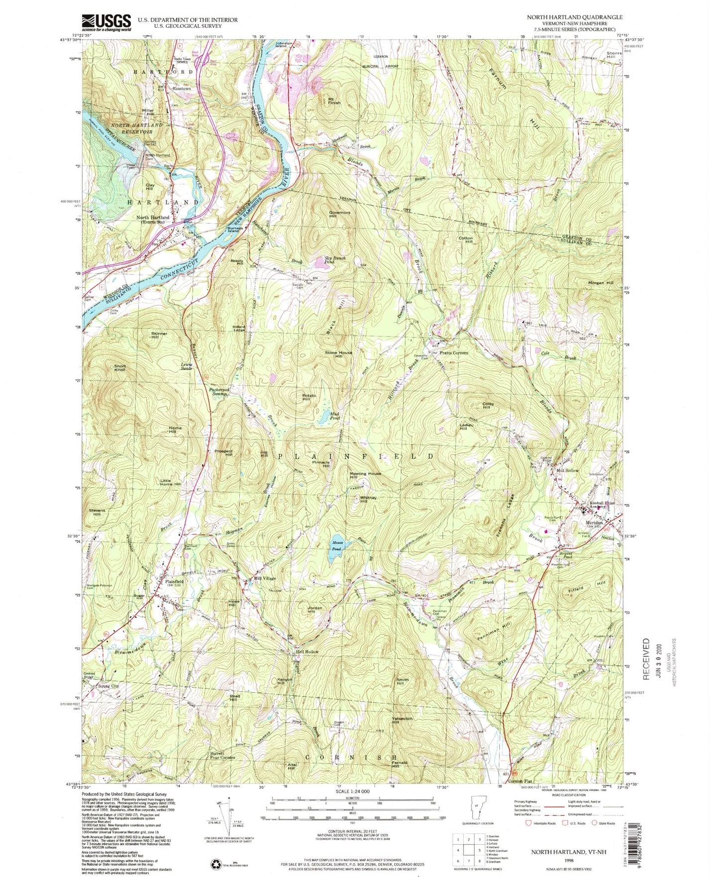
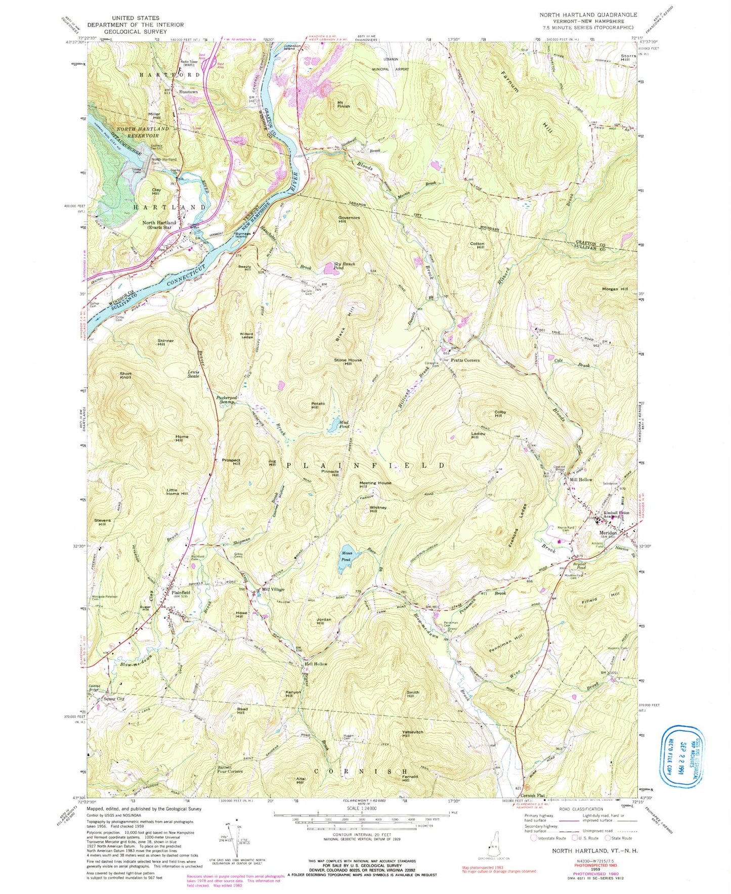
Classic USGS North Hartland Vermont 7.5'x7.5' Topo Map
Couldn't load pickup availability
Historical USGS topographic quad map of North Hartland in the states of Vermont, New Hampshire. Typical map scale is 1:24,000, but may vary for certain years, if available. Print size: 24" x 27"
This quadrangle is in the following counties: Grafton, Sullivan, Windsor.
The map contains contour lines, roads, rivers, towns, and lakes. Printed on high-quality waterproof paper with UV fade-resistant inks, and shipped rolled.
Contains the following named places: Clay Hill, Gallup Cemetery, Miller Hill, North Hartland, North Hartland Dam, Russtown, Ottauquechee River, WNHV-AM (White River Junction), North Hartland Community Church, North Hartland Dam Recreation Area, North Hartland Post Office, Ottauquechee River Bridge, Russtown Cemetery, Willard Covered Bridge, Hartland Volunteer Fire Department Station 2, North Hartland Census Designated Place, Altai Hill, Barrett Four Corners, Beauty Hill, Beaver Brook, Black Hill, Bloods Brook, Bryant Brook, Bryant Pond, Burnaps Island, Burr Brook, Clay Brook, Colby Cemetery, Colby Hill, Cole Brook, Cooney Hollow, Coreyville Cemetery, Cotton Hill, Cranberry Pond, Daniels Brook, Daniels Cemetery, Farnum Hill, Fernald Hill, Fifield Hill, Mount Finish, Frenchs Ledge, Frog Hollow, Gilkey Cemeteries, Governors Hill, Hanchetts Brook, Hibbard Brook, Hilliard Brook, Home Hill, Hopkins Cemetery, Howe Hill, Huggin Cemetery, Johnston Island, Jordan Hill, Jug Hill, Kenyon Hill, Kimball Union Academy, Ladieu Hill, Lewis Swale, Little Home Hill, Martin Brook, Meriden, Mill Cemetery, Moses Pond, Moulton-Yard Cemetery, Mud Pond, Newton Brook, Penniman Brook, Penniman Cemetery, Penniman Hill, Pinnacle Hill, Plainfield, Plainfield Cemetery, Potato Hill, Pratts Corners, Prospect Hill, Puckerpod Swamp, Raynis-Ford Cemetery, Read Hill, Shipman Brook, Short Knoll, Skinner Hill, Sky Ranch Pond, Smith Hill, Stevens Hill, Stockwell Brook, Stone House Hill, Storrs Hill, Sugar Hill, Westgate-Peterson Cemetery, Whitney Hill, Willard Ledge, Wine Brook, Yatsevitch Hill, Hell Hollow, Mill Hollow, Mill Village, Squag City, Meeting House Hill, Air-Wood Heliport, Town of Plainfield, Storrs Pond Dam, Storrs Pond, Meriden Bridge, Barnes Library, Plainfield Elementary School, Plainfield Community Baptist Church, Blow-Me-Down Bridge, Plainfield Post Office, Meridan Post Office, Plainfield Fire Department, Meriden Fire Department, Poverty Lane Orchard, Riverview Farm, Plainfield Census Designated Place, Plainfield Police Department