MyTopo
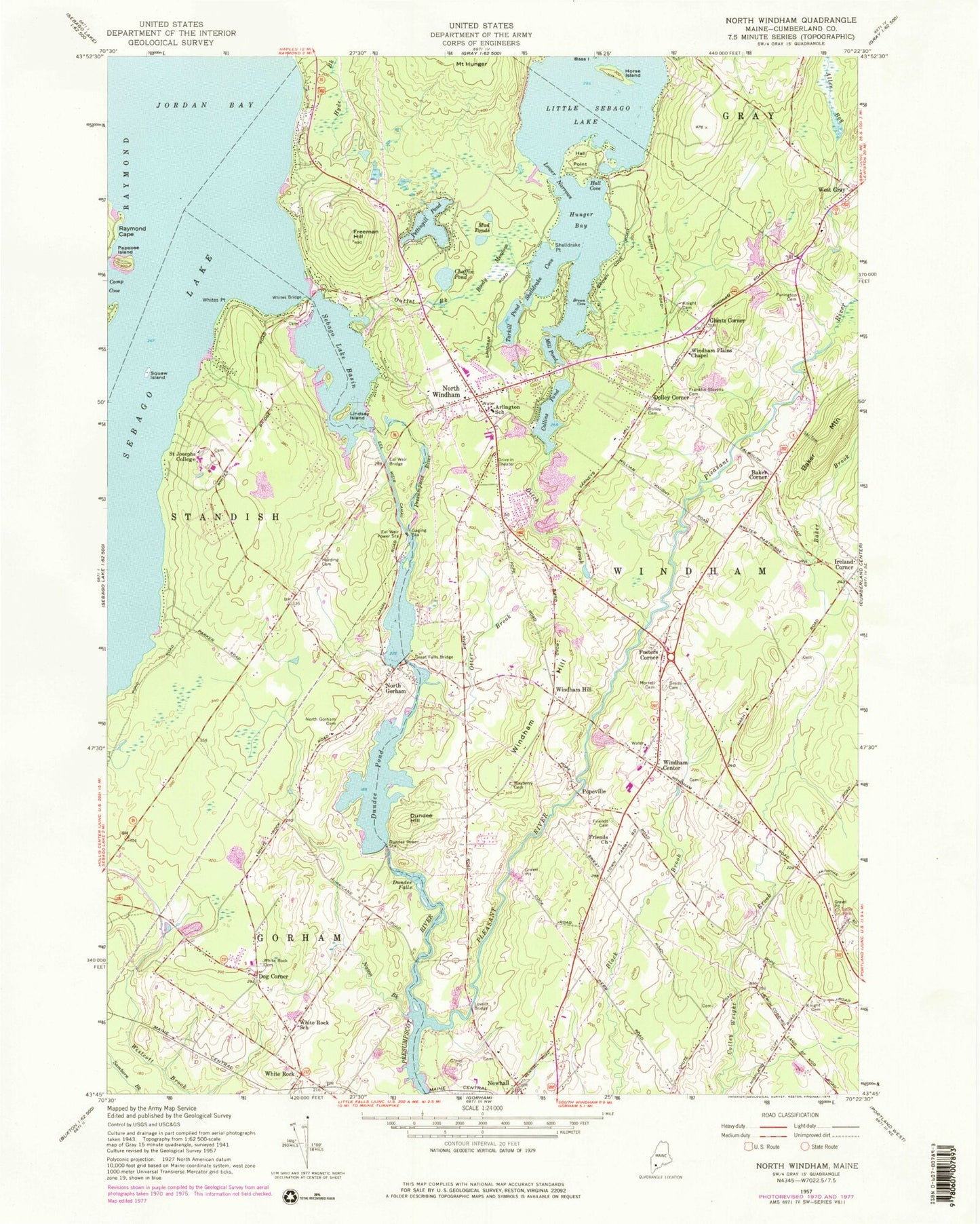
Classic USGS North Windham Maine 7.5'x7.5' Topo Map
Couldn't load pickup availability
Historical USGS topographic quad map of North Windham in the state of Maine. Typical map scale is 1:24,000, but may vary for certain years, if available. Print size: 24" x 27"
This quadrangle is in the following counties: Cumberland.
The map contains contour lines, roads, rivers, towns, and lakes. Printed on high-quality waterproof paper with UV fade-resistant inks, and shipped rolled.
Contains the following named places: Allen Bog, Arlington School, Baker Brook, Baker Corner, Baker Mountain, Boody Meadow, Brown Cove, Camp Cove, Chaffin Pond, Collins Pond, Ditch Brook, Dog Corner, Dolley Cemetery, Dolley Corner, Dundee Falls, Dundee Hill, Dundee Pond, Eel Weir Bridge, Eel Weir Canal, Fosters Corner, Franklin Stevens Cemetery, Freeman Hill, Friends Cemetery, Friends Church, Glantz Corner, Great Falls Bridge, Hall Cove, Hall Point, Harding Cemetery, Horse Island, Hunger Bay, Ireland Corner, Knight Cemetery, Knight Cemetery 2, Lindsay Island, Loveitt Bridge, Lower Narrows, Mayberry Cemetery, Mill Pond, Morrell Cemetery, Mud Ponds, Nason Brook, Newhall, North Gorham, North Gorham Cemetery, North Windham, Otter Brook, Outlet Brook, Papoose Island, Pettingill Pond, Pleasant River, Popeville, Purinton Cemetery, Raymond Cape, Saint Joseph's College of Maine, Sebago Lake Basin, Shelldrake Cove, Shelldrake Point, Smith Cemetery, Merrill Isle, Tarkill Pond, West Gray, White Rock, White Rock Cemetery, White Rock School (historical), Whites Bridge, Whites Point, Windham Center, Windham Hill, Windham Hill, Windham Plains Chapel, Dundee Power Station, Eel Weir Power Station, WSJB-FM (Standish), Sand Bar Seaplane Base, Town of Windham, Dundee Pond Dam, North Gorham Dam, Eel Weir Dam, Eel Weir Canal, Sebago Lake Dam, Mill Pond Dam, Little Sebago Lake Dam, Allie Hawks Hill, Arlington Cemetery, Babbs Bridge, Boody Hill, Chute Cemetery, Clubhouse Cove, Crendell Hill, Dutton Hills Brook, Elmer Brook, Friends School (historical), Gates Hill (historical), Gillman Island, Glantz Brook, Godd Cemetery, Great Falls (historical), Hall Cove, Harding School (historical), Haskell Brook, Hill School (historical), Kathleen and Daniel Wellehan Library, Kimball Hill, Knight Hill, Lebi Hall School (historical), Legrand Brook, Loveitt Cemetery, Lowells Corner (historical), Manchester School, Mugford Family Cemetery, Nash Hill, North Windham Shopping Center, Ollie Brook, Reed Hill, Rollins Hill, Saint Anns Episcopal Church, Shelldrake Point, Stanley Hall Brook, White Rock Baptist Church, Whites Hill, Windham Baptist Church, Windham Post Office, Windham Christian Life Center, Windham High School, Windham Hill Cemetery, Windham Hill United Church of Christ, Windham Mall Shopping Center, Windham Middle School, Windham Primary School, Windham Public Library, Windham Town Hall, Woodbury Hill, Timmons Hill, United Church of Christ at North Gorham, Knight School (historical), North Windham Census Designated Place, Slip Knot Landing, Windham Fire Rescue Department Central Station, Windham Fire Rescue Department North Station, Gorham Fire Department White Rock Station, Gorham Fire Department North Gorham Station, Windham Police Department, Austin Cemetery, Goudreau Family Burying Ground Cemetery, Hanson Burial Ground, Jedediah Lumbard Cemetery, Wescoat Eliakim Cemetery, White Family Cemetery, Little Log Cabin Montessori School, Windham Christian Academy, Saint Joseph's College Wellehan Library, North Gorham Public Library, Friends Cemetery