MyTopo
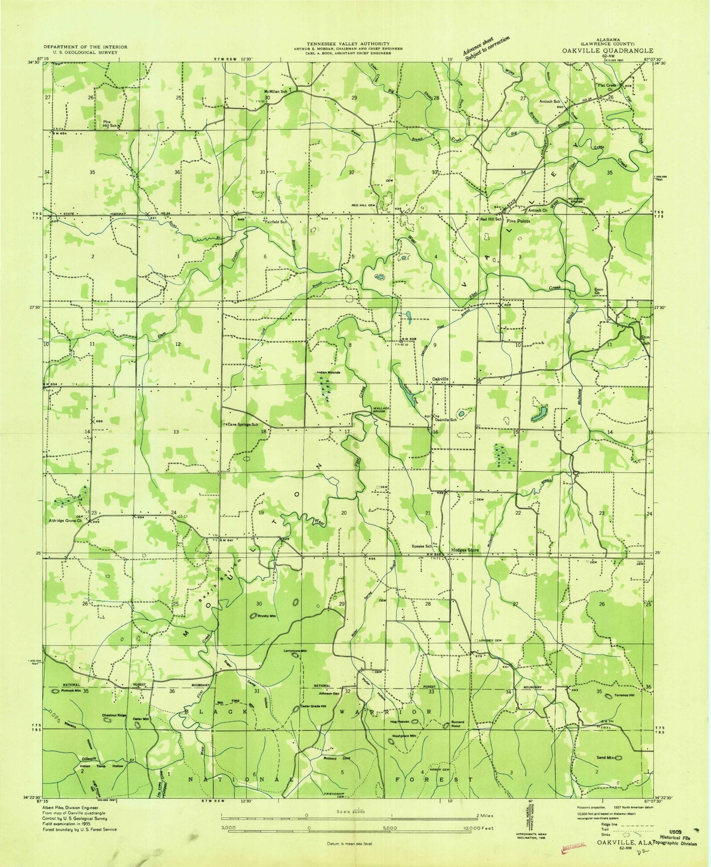
Classic USGS Oakville Alabama 7.5'x7.5' Topo Map
Couldn't load pickup availability
Historical USGS topographic quad map of Oakville in the state of Alabama. Map scale may vary for some years, but is generally around 1:24,000. Print size is approximately 24" x 27"
This quadrangle is in the following counties: Lawrence.
The map contains contour lines, roads, rivers, towns, and lakes. Printed on high-quality waterproof paper with UV fade-resistant inks, and shipped rolled.
Contains the following named places: Aldridge Cemetery, Aldridge Grove, Aldridge Grove Church of Christ, Alexander - Welborn Cemetery, Alexander Cemetery, Antioch Church, Antioch School, Arbor Cemetery, Bald Knob Church, Barnes Cemetery, Beaver Pond Branch, Beech Bottom, Berea Church, Big Shoal Creek, Brushy Mountain, Buck Branch, Buzzard Cove, Buzzard Roost, Camp Ground Church, Cave Springs School, Cedar Branch, Cedar Creek, Cedar Grade Hill, Cedar Mountain, Chestnut Ridge, Cold Branch, Cooper Cemetery, Dement Cemetery, Echota Cherokee State Designated Tribal Statistical Area, Elam Creek, Enon Baptist Church, Enon School, Fairfield, Fairfield Church, Fairfield Church of Christ, Fairfield School, Five Points, Flat Creek, Gibson Cemetery, Gillespie Creek, Hampton Cemetery, Happy Hollow, Hendon School, Highway 36 Church, Hill Cemetery, Hodges Cemetery, Hog Heaven, Indian Tomb Hollow, Jesseton, Johnson Cemetery, Kitchens Cemetery, Kitchens Mill, Lebanon Cemetery, Lebanon Church of God, Lee Creek, Lindsey Branch, Lindsey Cemetery, Little Shoal Creek, McDaniel Bridge, McDaniel Creek, McMillan School, Miller Cemetery, Miller Spring, Millfield Mountain, Moody Cemetery, Moulton Speedway, Mull Mountain, Oakville, Oakville Church, Oakville Pond, Oakville Pond Branch, Oakville School, Oakville Spring, Old Friendship Cemetery, Paff Cemetery, Pine Hill School, Pinhook Mountain, Porter Hollow, Preuit Cemetery, Red Hill Cemetery, Red Hill School, Rocky Branch, Rocky Gap, Sand Mountain, Sheats Branch, Speake, Speake Cemetery, Speake High School, Speake Volunteer Fire and Rescue Station 1, Speake-Oakville Division, Stephenson Cemetery, Stevens Hollow, Stover Branch, Stover Cemetery, Sugar Camp Hollow, Tacky Branch, Thompson Creek, Torrence Hill, Union Grove Church, Valley Grove Church, Wallace Bridge, Warren Cemetery, Washspring Mountain, Watkins Cemetery, Watson Branch, Watson Cemetery, Wilborn Cemetery, Woodard Cemetery, ZIP Code: 35619