
MyTopo
Classic USGS Ocean City New Jersey 7.5'x7.5' Topo Map
Couldn't load pickup availability
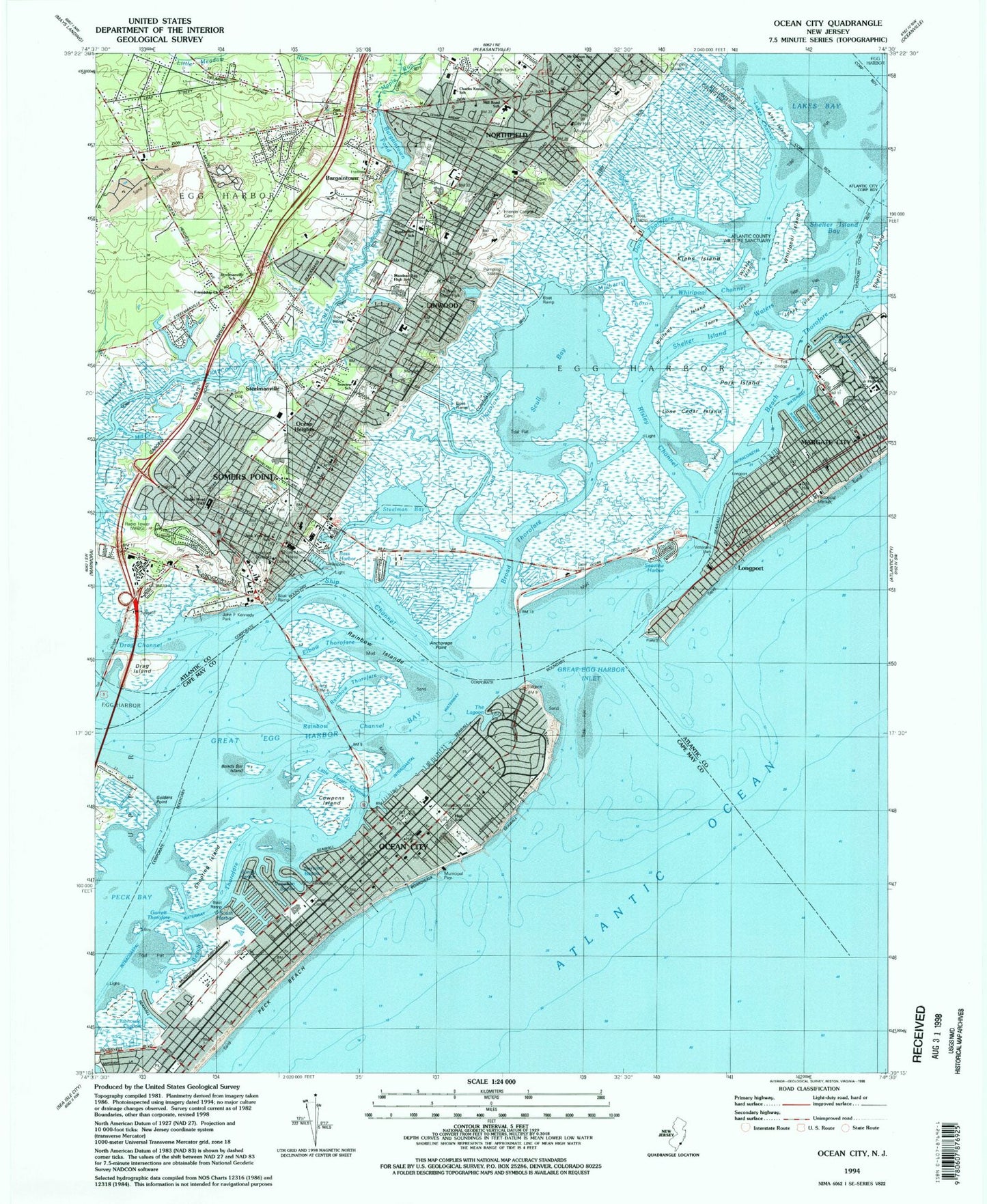
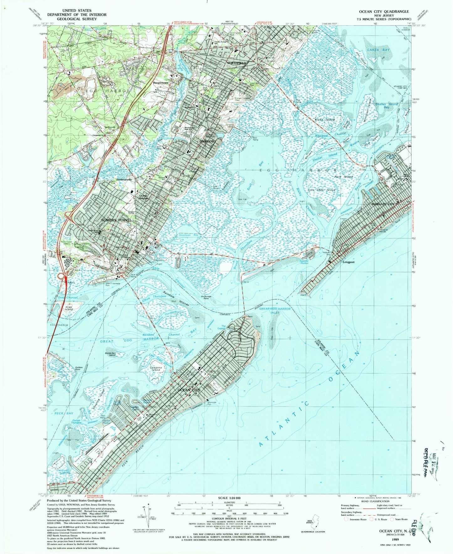
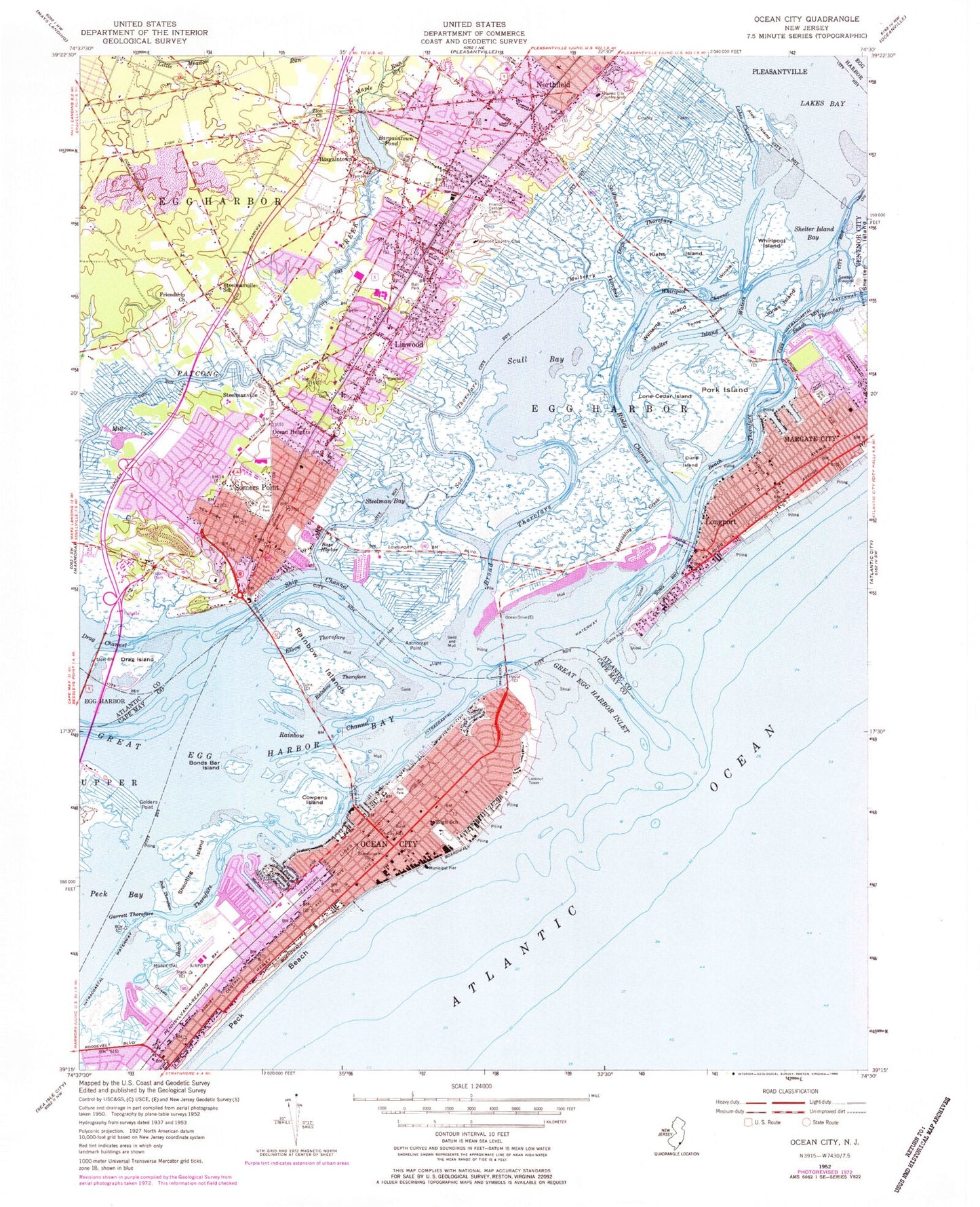
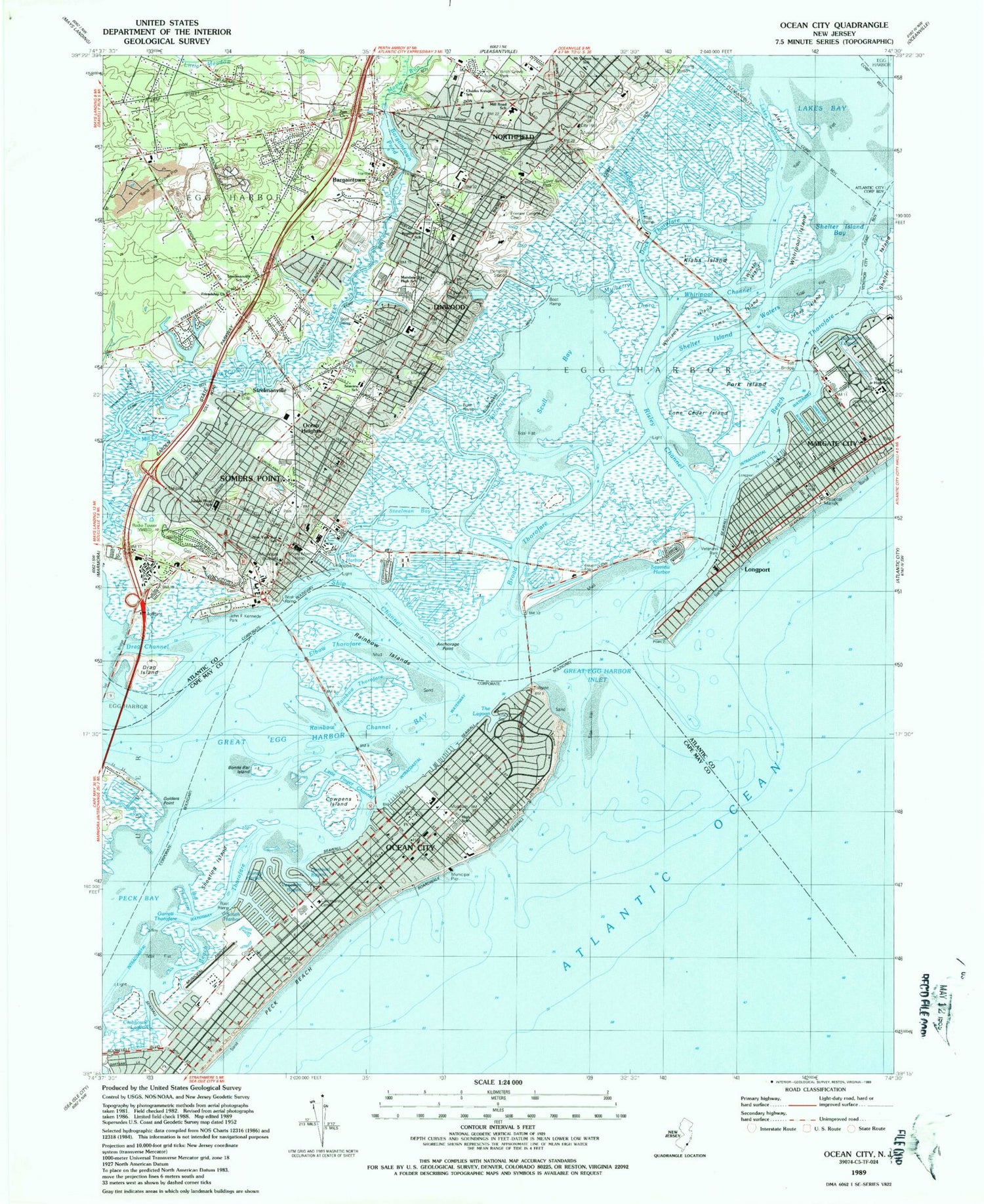
Historical USGS topographic quad map of Ocean City in the state of New Jersey. Typical map scale is 1:24,000, but may vary for certain years, if available. Print size: 24" x 27"
This quadrangle is in the following counties: Atlantic, Cape May.
The map contains contour lines, roads, rivers, towns, and lakes. Printed on high-quality waterproof paper with UV fade-resistant inks, and shipped rolled.
Contains the following named places: Clubhouse Lagoon, South Harbor, Little Finger Channel, The Lagoon, Mount Vernon Avenue School, Birch Grove Park, Charles Kresge School, Seaview School, Mill Road School, Cove Avenue Park, Poplar Avenue School, Mainland Regional High School, All Wars Memorial Park, Jordan Road School, New York Avenue School, John F Kennedy Park, Isaacs Creek, Lone Cedar Island, Tighe Junior High School, Jerome Avenue Park, Seaview Harbor, Jordan Road School, WIBG Radio Tower (Conway), Lone Cedar Island, Jerome Avenue Park, All Ways Memorial Park, Mainlaid High School, Shore Medical Center, New York Avenue School, Seaview School, Mill Road School, Birch Grove Park, Charles Kresqe School, Poplar Avenue School, Cove Avenue Park, Mount Vernon Avenue School, South Harbor, Little Finger Channel, John F Kennedy Park, Seaview Harbor, Alex Island, Anchorage Point, Bargaintown, Bargaintown Pond, Bass Harbor, Bonds Bar Island, Broad Thorofare, Bull Thorofare, Carnival Bayou, Cowpens Island, Dock Thorofare, Drag Channel, Drag Island, Dune Island, Elbow Thorofare, Friends Central Cemetery, Friendship Church, Garrett Thorofare, Golders Point, Great Egg Harbor Bay, Great Egg Harbor Inlet, Hospitality Creek, Jonas Island, Kiahs Island, Lakes Bay, Lakes Channel, Linwood, Longport, Maple Run, Margate City, Mill Branch, Mill Creek, Mulberry Thorofare, Northfield, Ocean City, Ocean Heights, Peck Bay, Pork Island, Rainbow Channel, Rainbow Islands, Rainbow Thorofare, Risley Channel, Scull Bay, Shelter Island Bay, Shelter Island Waters, Ship Channel, Shooting Island, Sod Thorofare, Somers Point, Steelman Bay, Steelmanville, Steelmanville School, Stillman Creek, Toms Island, Venetian Bayou, Whirlpool Channel, Whirlpool Island, Williams Island, Winkle Island, Zion Church, Ocean Heights Station, Linwood Station, Bakersville Station, Bayshore Lagoon, Orient Canal, Sunset Canal, Atlantic City Country Club, Linwood Country Club, Sunny Harbor, Sans Souci Estate Helistop, Dix Field, Ocean City Municipal Airport, Shore Memorial Hospital Heliport, WIBG-AM (Ocean City-Somers Point), City of Linwood, Borough of Longport, City of Margate City, City of Northfield, City of Ocean City, City of Somers Point, Charter Tech High School for Performing Arts, Eagle Academy Alternative School, Dawes Avenue Elementary School, Blessed Sacrament Regional Elementary School, Saint Joseph Regional School, William H Ross III Intermediate School, Intermediate Elementary School, Saint Augustine Regional Elementary School, Jewish Community Day School, Primary Elementary School, Northfield Community Elementary School, Northfield Community Middle School, Belhaven Avenue Middle School, Creative Learning Preschool, Union Avenue Elementary School, Ocean City High School, Ocean City Fire and Rescue Services Department Headquarters, Somers Point City Fire Department - Chief, Northfield Fire Department, Longport Volunteer Fire Department, Linwood Volunteer Fire Company 1, Linwood Rescue Squad, Somers Point City Fire Company 1 Station 2, Bargaintown Volunteer Fire Company 2 Station 2, Margate City Fire Department Station 1, Somers Point Fire Department Fire Company 1, Ocean City Fire and Rescue Services Department Station 2, Lucy The Margate Elephant, Mutual Aid Emergency Services, Ocean City Police Department, Somers Point Police Department, Egg Harbor Township Police Department, Linwood Police Department, Longport Beach Patrol, Northfield Police Department, Margate City Police Department, Longport Police Department, Margate Towers, Island House, Ocean City Post Office, Longport Post Office, Linwood Post Office, Somers Point Post Office, Bargaintown Census Designated Place, Clubhouse Lagoon, South Harbor, Little Finger Channel, The Lagoon, Mount Vernon Avenue School, Birch Grove Park, Charles Kresge School, Seaview School, Mill Road School, Cove Avenue Park, Poplar Avenue School, Mainland Regional High School, All Wars Memorial Park, Jordan Road School, New York Avenue School, John F Kennedy Park, Isaacs Creek, Lone Cedar Island, Tighe Junior High School, Jerome Avenue Park, Seaview Harbor, Jordan Road School, WIBG Radio Tower (Conway), Lone Cedar Island, Jerome Avenue Park, All Ways Memorial Park, Mainlaid High School, Shore Medical Center, New York Avenue School, Seaview School, Mill Road School, Birch Grove Park, Charles Kresqe School, Poplar Avenue School, Cove Avenue Park, Mount Vernon Avenue School, South Harbor, Little Finger Channel, John F Kennedy Park, Seaview Harbor, Alex Island, Anchorage Point, Bargaintown, Bargaintown Pond, Bass Harbor, Bonds Bar Island, Broad Thorofare, Bull Thorofare, Carnival Bayou, Cowpens Island, Dock Thorofare, Drag Channel, Drag Island, Dune Island, Elbow Thorofare, Friends Central Cemetery, Friendship Church, Garrett Thorofare, Golders Point, Great Egg Harbor Bay, Great Egg Harbor Inlet, Hospitality Creek, Jonas Island, Kiahs Island, Lakes Bay, Lakes Channel, Linwood, Longport, Maple Run, Margate City, Mill Branch, Mill Creek