MyTopo
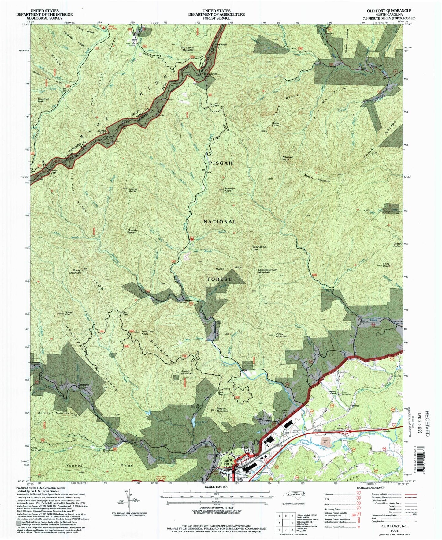
Classic USGS Old Fort North Carolina 7.5'x7.5' Topo Map
Couldn't load pickup availability
Historical USGS topographic quad map of Old Fort in the state of North Carolina. Typical map scale is 1:24,000, but may vary for certain years, if available. Print size: 24" x 27"
This quadrangle is in the following counties: McDowell, Yancey.
The map contains contour lines, roads, rivers, towns, and lakes. Printed on high-quality waterproof paper with UV fade-resistant inks, and shipped rolled.
Contains the following named places: Neals Creek Heliport, Setrock Creek, Bergen Mountain, Big Fork Ridge, Brevard Creek, Brookside Church, Brushy Branch, Burgins Fork, Camp Creek, Camp Grier, Camp Grier Lake, Camp Rock Branch, Chestnutwood Mountain, Curtis Creek, Deep Gap, Ebenezer Church, Flinty Gap, Grassy Ridge, Heartbreak Ridge, Hickory Branch, Horse Trail Gap, Jarrett Creek, Lead Mine Gap, Left Prong Newberry Creek, Licklog Branch, Licklog Creek, Long Branch, Long Branch, Mackey Mountain, Moses Ridge, Neals Creek, Newberry Creek, Old Fort, Parris Creek, Pine Mountain, Point Lookout, Poplar Ridge, Pritchard Creek, Right Prong South Toe River, Salt Gap, Sams Creek, Sams Ridge, Siloam Cemeteries, Singecat Branch, Slick Falls Branch, Star Gap, Straight Branch, Sugar Cave Creek, Tantrough Branch, Upper Creek, Walnut Cove Creek, Camp Grier Dam, Old Fort Elementary School, Bear Cave Branch, Old Fort Picnic Area, Piney Grove Church, Andrews Geyser, Curtis Creek Recreation Site, Green Knob Lookout, Green Knob, Briar Bottom Recreation Area, Buckeye Knob, Dendron, Iron Mountain, Jerdon Mountain, Laurel Knob, Licklog Knob, Long Ridge, Lost Cove Knob, Narrows Knob, Piney Mountain, Rocky Mountain, Sams Knob, Snooks Nose, Big Laurel Gap, Big Lost Cove Creek, Bear Drive Branch, Big Laurel Mountain, Cave Creek, Chestnut Knob, Chute Branch, Deep Branch, Flynn Ridge, Horse Branch, Laurel Fork Creek, Locust Creek, Lost Cove Ridge, Lower Creek, Paddys Branch, Laurel Log Branch, Sunnyvale, Swannanoa Creek, Whiteside Ridge, Township of Old Fort, Town of Old Fort, Old Fort Volunteer Fire Department, McDowell County Emergency Medical Services Station 2, Old Fort Post Office