MyTopo
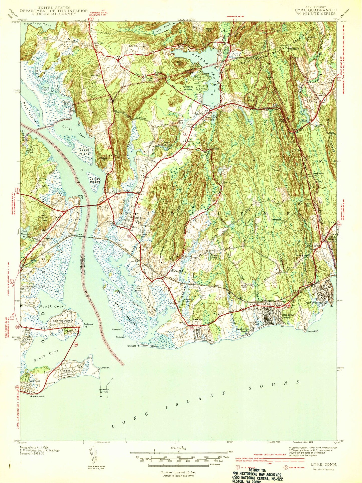
Classic USGS Old Lyme Connecticut 7.5'x7.5' Topo Map
Couldn't load pickup availability
Historical USGS topographic quad map of Old Lyme in the state of Connecticut. Typical map scale is 1:24,000, but may vary for certain years, if available. Print size: 24" x 27"
This quadrangle is in the following counties: Middlesex, New London.
The map contains contour lines, roads, rivers, towns, and lakes. Printed on high-quality waterproof paper with UV fade-resistant inks, and shipped rolled.
Contains the following named places: Amon Hill, Armstrong Brook, Artillery Hill, Back River, Beamon Creek, Becket Hill, Big Pond, Bills Hill, Black Hall, Black Hall Pond, Breakwater Lighthouse, Broad Swamp Brook, Champion Cemetery, Champion Cemetery, Connecticut River, Coults Hole, Cranberry Bottoms, Cranberry Ledge, Cypress Cemetery, Deep Creek, Deitch Pond, Duck River, Duck River Cemetery, Ely Cemetery, Fenwick, Fenwood, Ferry Hill, Ferry Point, Game Ledge, Gilbralter Rocks, Goose Island, Grassy Hill Brook, Great Island, Griswold Cemetery, Griswold Point, Guardhouse Point, Hamburg Cove, Hart Hill, Hatchett Point, Hawks Nest Beach, Johnnycake Hill, Laysville, Lieutenant River, Little Pond, Lord Cove, Lord Creek, Lord Hill, Lower Millpond, Lyme Station, Lynde Point, Mack Creek, Mile Creek, Mill Brook, Mink Island, Myer Hill, North Cove, Nott Island, Obed Heights Reservoir, Old Lyme, Old Lyme Shores, Olivers Hole, Otter Cove Estates, Plants Dam, Point O'Woods, Poverty Island, Poverty Point, Pumphouse Hill, Quarry Hill, Ragged Rock Creek, Rat Island, Raymond E Baldwin Bridge, Riverside Cemetery, Rogers Lake, Saint Anns Church, Saltworks Point, Sawmill Brook, Saybrook Beacon, Saybrook Jetties, Saybrook Lighthouse, Saybrook Point, Saybrook Point, Smith Ledges, Smiths Neck, Sodom Rocks, Sound View, South Cove, South Lyme, Springdale Pond, Swan Brook, Threemile River, Tinker Pond, Uncas Pond, Union Chapel, Upper Millpond, Waite Cemetery, Watrous Point, White Sands Beach, Jericho, Town Landing, Saybrook Breakwater, Griswolds Piers, Saybrook Outer Bar Channel, Saybrook Outer Bar, Calves Island Bar Channel, Saybrook Shoal Channel, Saybrook Shoal, Dickersons Pier, Calves Island Bar, Calves Island, Hatchett Reef, Old Lyme Country Club, Lord Creek Seaplane Base, Old Saybrook Heliport, Town of Old Lyme, Obed Heights Reservoir Dam, Rogers Lake Dam, Ayers Point, Boston Post Road Industrial Park, Collegiate College (historical), East Jetty, Fort Fenwick (historical), Fort Saybrook (historical), Fort Saybrook Monument Park, Gardner Statue, Gladeview Convalescent Home, Government Dock, Great Pier, Ingraham Rocks, Lady Fenwicks Grave, Miracle Temple Full Gospel Church, Old Saybrook Middle School, Old Saybrook Town Boat Landing, Old Saybrook Town Dock, River Street Industrial Park, Saybrook Village, West Jetty, Yacht Club Point, Yale Boulder, Floral Park, Bacon Landing, Beckett Hill State Park Reserve, Bills Hill School (historical), Black Hall Golf Club, Calves Island Bar, Calves Island Light, Center Elementary School, Christ the King Church, Cross Lane Recreation Area, Ely Hill, Ely Meadow, First Congregational Church, Florence Griswold Museum, Gibralter Rocks, Goodwins Pond, Great Bridge, Great Island Nature Area, Griswold Cove, Gunning Swamp, Hains Park, Lyme Academy of Fine Arts, Lyme Art Association Gallery, Lyme Historical Society Library, Marvin Island, Matson Hill (historical), Meeting House Hill, Miami Shores, Mile Creek School, Nut Museum, Old Lyme Green, Old Lyme High School, Old Lyme Historic District, Old Lyme Middle School, Old Lyme Post Office, Old Lyme Shopping Center, Our Lady of Good Counsel Chapel, Peck Tavern (historical), Phoebe Griffin Noyes Library, Poverty Island Beach, Pug Harbor, Soundview Beach, South Lyme Post Office, Swan Pond, The Shopping Center - Old Lyme Shopping Center, Trowbridge Corner (historical), Old Saybrook Center Census Designated Place, Borough of Fenwick, Old Lyme Fire Department Station 38, Old Lyme Fire Department Cross Lane Station, Old Lyme Fire Department Station 30, Old Lyme Fire Department North Station, Mile Creek Airport, Stone Ranch Military Reservation, Old Saybrook Ambulance Association, Lyndes Neck, Old Lyme Police Department, Shippee Pond, Amon Hill, Armstrong Brook, Artillery Hill, Back River, Beamon Creek, Becket Hill, Big Pond, Bills Hill, Black Hall, Black Hall Pond, Breakwater Lighthouse, Broad Swamp Brook, Champion Cemetery, Champion Cemetery, Connecticut River, Coults Hole, Cranberry Bottoms, Cranberry Ledge, Cypress Cemetery, Deep Creek, Deitch Pond, Duck River, Duck River Cemetery, Ely Cemetery, Fenwick, Fenwood, Ferry Hill, Ferry Point, Game Ledge, Gilbralter Rocks, Goose Island, Grassy Hill Brook, Great Island, Griswold Cemetery, Griswold Point, Guardhouse Point, Hamburg Cove, Hart Hill, Hatchett Point, Hawks Nest Beach