MyTopo
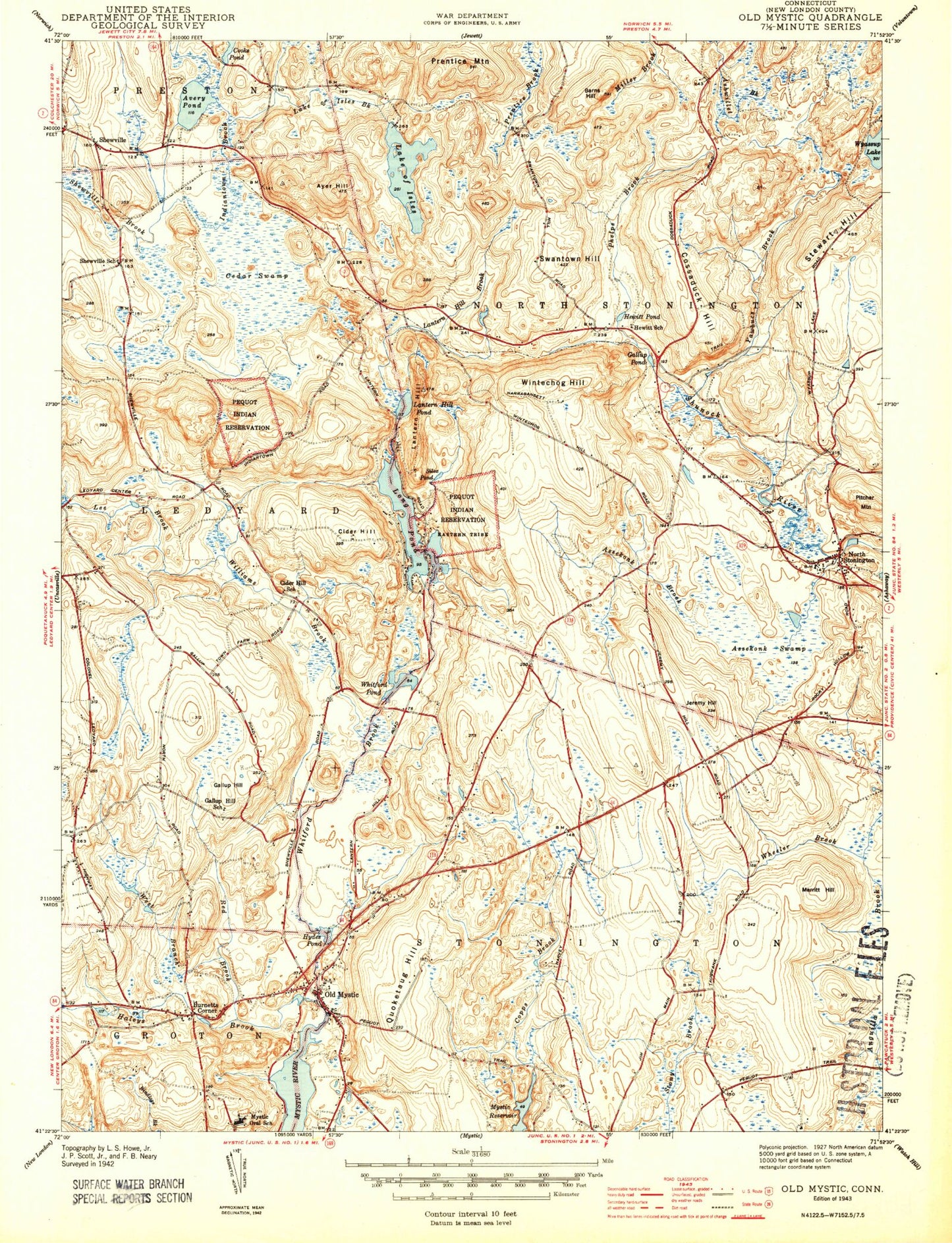
Classic USGS Old Mystic Connecticut 7.5'x7.5' Topo Map
Couldn't load pickup availability
Historical USGS topographic quad map of Old Mystic in the state of Connecticut. Typical map scale is 1:24,000, but may vary for certain years, if available. Print size: 24" x 27"
This quadrangle is in the following counties: New London.
The map contains contour lines, roads, rivers, towns, and lakes. Printed on high-quality waterproof paper with UV fade-resistant inks, and shipped rolled.
Contains the following named places: Assekonk Brook, Assekonk Swamp, Avery Cemetery, Avery Pond, Ayer Hill, Barns Hill, Cedar Swamp, Cider Hill, Cooks Pond, Cossaduck Hill, Fanning Cemetery, Gallup Cemetery, Gallup Hill, Gallup Pond, Haleys Brook, Hewitt Pond, Hewitt School, Lantern Hill Brook, Hyde Pond, Indiantown Brook, Jeremy Hill, Lake of Isles Brook, Lantern Hill, Lantern Hill Pond, Lee Brook, Long Pond, Main Brook, Merritt Hill, Mystic Education Center, Narragansett Trail, North Stonington, Lake Of Isles, Old Mystic, Paucatuck Eastern Pequot Reservation, Phelps Brook, Pitcher Mountain, Prentice Mountain, Quoketaug Hill, Red Brook, Shewville, Silex Pond, Stewart Hill, Swantown Hill, West Branch Red Brook, Wheeler Brook, Wheeler High School, Whitford Brook, Williams Brook, Wintechog Hill, Yawbucs Brook, Burnetts Corner, Mashantucket Pequot Reservation, Wychwood Field, Town of North Stonington, Long Pond Dam, Lake of Isles Dam, Lake of Isles, Deans Reservoir, Whitford Pond Dam, Tribrook Pond Dam, Tribrook Pond, Anchor Baptist Church, Avon Park, Board of Education Administration Office, Brown - Randall Cemetery, Browning Cemetery, Butler Library, Cider Hill School (historical), Clydes Cider Mill, Corey Sub Park, Creston Plains Elementary School, Denison Cemetery, Fieldcrest Park, Foxwoods Casino, Freeman Hathaway Recreation Center, Freeman Hathaway School, Gallup Hill Baptist Church, Gallup Hill Elementary School, Gallup Hill School (historical), Gore Cemetery, Hewitt School (historical), Highland Lake Park, Indian and Colonial Research Center, Ledyard Assembly of God Church, Lords Pond, Lozier Sub Park, Mystic Carousel and Fun Center, North Stonington Church, North Stonington Elementary School, North Stonington Post Office, North Stonington Town Hall, North Stonington Town Recreation Area, North Stonington Village Historic District, Old Mystic Baptist Church, Old Mystic Grammar School, Old Mystic Post Office (historical), Old Mystic United Methodist Church, Pequot Golf Course, Pumpkin Hill, River Road Park, Saint Thomas Moore Church, Seaport Campground, Shady Oaks Park, Shewville School (historical), Stewart Hill Cemetery, Stonington Vineyards, Swan Cemetery, Third Baptist Church, Wheeler High School, Wheeler Library, Wheeler Middle School, Whitehall Landing, Whitehall Mansion, Woodward Cemetery, Assekonk Swamp State Wildlife Management Area, Old Mystic Census Designated Place, Mystic Volunteer Fire Department Headquarters, Old Mystic Fire Department Station 1, North Stonington Volunteer Fire Company, Mashantucket Pequot Fire Department, Mashantucket Census Designated Place, North Stonington Ambulance Association, Preston Resident State Patrol Office, Old Mystic Post Office, Assekonk Brook, Assekonk Swamp, Avery Cemetery, Avery Pond, Ayer Hill, Barns Hill, Cedar Swamp, Cider Hill, Cooks Pond, Cossaduck Hill, Fanning Cemetery, Gallup Cemetery, Gallup Hill, Gallup Pond, Haleys Brook, Hewitt Pond, Hewitt School, Lantern Hill Brook, Hyde Pond, Indiantown Brook, Jeremy Hill, Lake of Isles Brook, Lantern Hill, Lantern Hill Pond, Lee Brook, Long Pond, Main Brook, Merritt Hill, Mystic Education Center, Narragansett Trail, North Stonington, Lake Of Isles, Old Mystic, Paucatuck Eastern Pequot Reservation, Phelps Brook, Pitcher Mountain, Prentice Mountain, Quoketaug Hill, Red Brook, Shewville, Silex Pond, Stewart Hill, Swantown Hill, West Branch Red Brook, Wheeler Brook, Wheeler High School, Whitford Brook, Williams Brook, Wintechog Hill, Yawbucs Brook, Burnetts Corner, Mashantucket Pequot Reservation, Wychwood Field, Town of North Stonington, Long Pond Dam, Lake of Isles Dam, Lake of Isles, Deans Reservoir, Whitford Pond Dam, Tribrook Pond Dam, Tribrook Pond, Anchor Baptist Church, Avon Park, Board of Education Administration Office, Brown - Randall Cemetery, Browning Cemetery, Butler Library, Cider Hill School (historical), Clydes Cider Mill, Corey Sub Park, Creston Plains Elementary School, Denison Cemetery, Fieldcrest Park, Foxwoods Casino, Freeman Hathaway Recreation Center, Freeman Hathaway School, Gallup Hill Baptist Church, Gallup Hill Elementary School, Gallup Hill School (historical), Gore Cemetery, Hewitt School (historical), Highland Lake Park, Indian and Colonial Research Center, Ledyard Assembly of God Church, Lords Pond, Lozier Sub Park, Mystic Carousel and Fun Center, North Stonington Church, North Stonington Elementary School, North Stonington Post Office, North Stonington Town Hall, North Stonington Town Recreation Area, North Stonington Village Historic District, Old Mystic Baptist Church, Old Mystic Grammar School, Old Mystic Post Office (historical), Old Mystic United Methodist Church, Pequot Golf Course, Pumpkin Hill, River Road Park, Saint Thomas Moore Church, Seaport Campground, Shady Oaks Park, Shewville School (historical), Stewart Hill Cemetery, Stonington Vineyards, Swan Cemetery, Third Baptist Church, Wheeler High School, Wheeler Library, Wheeler Middle School, Whitehall Landing